

GORGE WIND FORECAST
If you’re still seeing yesterday’s and it’s after 9am, try opening this in an incognito window
SHORT-TERM gorge wind forecast
Hi friends! Another windy day is on tap today thanks to a trough pushing some low clouds into the west side of the region this morning. Reinforcing cool air = good! Lesser westerlies, but still enough for many of you, are forecast Sunday. We then move into windsport rest day territory Monday and Tuesday before westerlies return with cooler weather on Wednesday and probably linger for the rest of next week. Need an alternative sport for Monday and Tuesday? Thanks to copious rain in the storms night before last, the dirt is perfect for mountain biking – consider this alternative!
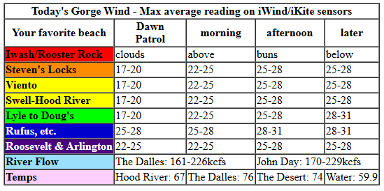
On to today’s forecast… For whatever reason, The Dalles airport pressure report is offline this morning. We’re left with this: 30.25 (pdx), 30.18 (Hood River), and 30.09 (Pasco). That’s 0.16 across the Gorge, and a good sign for today. A trough (cool air) reinforces the marine clouds into mid-morning, which allows the desert to get a jump on heating. Early wind was 17-20mph between Viento and Doug’s, 25-30mph in the Rufus zone, 17-20mph at Arlington, and 10-13mph at Stevenson, where clouds are going to increase. By mid-morning, we’ll have 22-25mph from Viento to Rufus with 17-20mph at Arlington and gusty 15-20mph at cloudy Stevenson.
Afternoon wind builds to 25-28mph from Stevenson to Mosier with 28-31mph from Lyle to Rufus and 25-28mph at Arlington. River flow over the last 24 hours was 161-229kcfs (170-229kcfs at Rufus), river temp is 59.9F, and high temp forecast is SIX-SEVEN in Hood River and 75F in the desert.
RIVER FLOW FOR SITES BETWEEN AVERY (EAST OF THE DALLES) AND RUFUS: CLICK HERE FOR JOHN DAY DAM FLOW.
RIVER FLOW FOR SITES BETWEEN STEVENSON AND DOUG’S BEACH (WEST OF THE DALLES): CLICK HERE FOR THE DALLES DAM FLOW

LONGER-TERM gorge wind forecast
Sunday kicks off partly cloudy to the west and sunny to the east with 18-21mph between Viento and the Hatch. Stevenson: cloudy and 10-13mph. East of the Hatch: 10-13mph all the way to Arlington. Afternoon wind rises to 20-23mph from Stevenson to Mosier with 17-20mph near Rowena. The Lyle-Doug’s stretch eventually fills in at 20-23mph, and Avery picks up to 17-20mph. Areas to the east stay below 15mph all day with less than 10mph east of Rufus. High temp: 73F in Hood River and 77F in the desert.
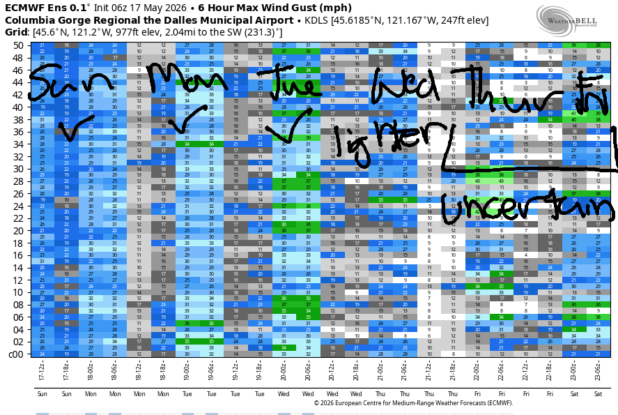
High pressure builds inland on Monday. This gives us calm wind to start. Easterlies rise to 15mph near Stevenson midday before fading in the afternoon. High temp: 81F. Tuesday starts calm. As the heat low shifts inland in the afternoon, westerlies return. If we’re lucky, they’ll rise to 17-20mph late in the day between Stevenson and Hood River, but the wind usually under-performs in this setup, so we’re unlikely to hit that target. High temp: 85F. For stronger results on Tuesday, try Jones Beach, where the forecast is 25-28mph.
A trough of cooler air helps us out on Wednesday; much stronger westerlies are forecast. As of this morning, we’re looking at 27-30mph or so. Uncertainty increases as we move deeper into next week; the weather looks rather active, which isn’t ideal for our wind. That said, westerlies (on the gustier side of steady) are likely to persist as a thermal gradient keeps the westerlies going. See you on the Nch’i Wana soon!

Was that helpful? I knew it was! Guess what? All of this crucial work – from your personal wind and snow reports to the invaluable TATAS updates – is made possible by my relentless efforts. Maintaining this labor of love isn’t easy. Each daily forecast takes hours. Website hosting, weather model access, and back-end admin work takes time and money. That’s where you come in.
YOUR CONTRIBUTION MAKES A DIFFERENCE
- SUPPORT ACCURATE, HYPER-LOCAL WEATHER FORECASTING
- ENABLE ACCESS FOR ALL, EVEN THOSE WITH LESS MEANS
- SUPPORT A COOL HUMAN WHO WORKS HARD SO YOU CAN PLAY
Take a moment to click one of the buttons below. Donate $19.99 or more (how much does this forecast enhance your life?) and get the email in your inbox. Whether it’s a renewing subscription (auto-renew) or a one-time donation, every contribution makes a real difference. Help me keep this labor of love alive, so we can all continue playing, commuting, and living in the Gorge with peace of mind and the best weather forecasts possible. Thank you!


Hood River, Oregon 97031


JONES BEACH, SAUVIE ISLAND, & COAST FORECAST
Wind northerly unless otherwise indicated. For coast, it’s North/Central/South with the “central” at approximately Florence. Swell forecast from NWS for central coast. Jones: westerly unless otherwise stated. Sauvie Island: northerly unless otherwise stated.
Coast Saturday: 15/20/30-35, NW swell 6′ at 12 seconds. Sunday: 20-25/25-30/35-40, W 5′ @ 11. Monday: 20/20/25-30, NW 5′ @ 9. Jones Saturday: 17-20. Sunday: 17-20. Monday: 10-13. Sauvie Island Saturday: 10-13. Sunday: 14-17. Monday: 11-14.
BARE BONES HOOD RIVER WEATHER FORECAST
Clear early with low clouds increasing then decreasing. Temps start in the upper 40s and rise to the mid-upper 60s. Moderately strong to strong westerlies. No rainbows. Sunday will be partly cloudy then mostly clear. Temps start in the low 40s and rise to the low 70s. Moderately strong westerlies. No rainbows. Monday will be sunny then partly cloudy. Temps start in the mid 40s and rise to the low 80s. Calm wind becoming light easterly then calm. No rainbows.
TEMIRA’S AWESOME TRAVEL ADVISORY SERVICE
HYPERLOCAL WEATHER FORECAST FOR THE COLUMBIA GORGE
THE DALLES, HOOD RIVER, WHITE SALMON, TROUT LAKE, STEVENSON, CASCADE LOCKS, PARKDALE, ODELL, HUSUM, BZ, MILL A, WILLARD, GOLDENDALE, RUFUS, ARLINGTON, boardman

Good morning, neighbors! Other than wind, quiet weather is in the cards for the next several days. Next chance of any rain looks to be next weekend. If it rains, it would come from the west, which makes it less like to progress as far east as any cherries. High temps will be under 80 the next couple of days and will rise above 80 for all of us Monday and Tuesday. Best chance of zero wind: Monday all day and Tuesday in the morning. Spray, baby, spray!
Glenwood and other friends this morning
Saturday starts partly cloudy to the west and sunny to the east with less wind than yesterday but still a stiff breeze. Actually, it’s not all that stiff – this morning’s wind is like a half-mast wiener, but it will full engorge this afternoon. As expected this morning, we have some chilly spots: Dufur is 33F, Glenwood is 32F, and the Upper Valley is 36-38F. Our friends in Tehran are expecting 90 degrees with 9% humidity, and our friends in Havana are expecting 88 degrees, 73% humidity, and a 35% chance of rain. Muscat, Oman, is expecting 105F and 23% humidity, which is going to feel quite hot – the weather will cool down below 100F there by next weekend.
Today’s Gorge weather forecast
A cool, pleasant day is on tap here. TATAS’ favorite weather is 65-75F and breezy, and we’ve got it today! Clouds increase west of Hood River this morning in response to a trough (not the kind that horses eat from), and then clouds decrease this afternoon leaving all of us sunny. Lowland high temps range from 65F in Stevenson, 70F in The Dalles, and 74F way out in Pasco (watch for the bighorn sheep while you’re driving there). West wind builds to 25-30mph from Stevenson to Rufus by early afternoon with 25mph near Arlington.
Sunday’s Gorge weather forecast
Overnight, we’ll see a few clouds west of Hood River and clear sky elsewhere. Once again, Dufur and Glenwood drop to 32-36F. Elsewhere: 40-50F. Westerlies will be 15-20mph right off the bat west of Mosier and 10-15mph east of Mosier to Arlington. Afternoon wind builds to 20-25mph between Stevenson and Murdoch with 15-20mph in The Dalles and 10mph or less to the east. High temps range from 71F in Stevenson, 73F in Hood River, and 76-77F from The Dalles east to the watermelons in Hermiston. Speaking of watermelons, I planted by 262.7 Crawford yesterday. His name will be Wandy-melon. Last year we grew a 168lb watermelon – so far, we’re not seeing the heat necessary to repeat that feat, but we’ll try. Also in the ground: two eggplants, one named Mr. Iverson, and one named Dick.
Extended Gorge weather forecast
Monday kicks off clear and calm with everyone scrambling to spray. Afternoon adds just a few mid and high clouds. Thanks to high pressure and warming aloft, temps rise to the low-mid 80s all across the lowlands, warmest in The Dalles, Peak wind Monday will be out of the east at 15mph near Stevenson midday. Another warm, sunny day is forecast Tuesday with this from 85-88F. After a dead calm start, westerlies build to 10-15mph west of Mosier in the afternoon. Elsewhere: calmish.
Thankfully, that’ll be the end of our “hot” spell – cooler weather is forecast on Wednesday. As per usual, the cooling will be accompanied by stronger westerlies. For the rest of next week, we’ll have TATAS’ fav weather: breezy and under 75 degrees. Yay! It ain’t great for growing watermelons and other giant fruits and vegetables, but it sure is good for just existing as a human being. Take good care today, folks. Be kind. Safe travels. -TATAS
HEY! DON’T STOP READING! Is this community-focused forecast helpful to you? It sure is! It takes me a couple hours a day to write. Please join your friends and neighbors in contributing to keep it going. Venmo: @thegorgeismygym PayPal: twomirrors@gmail.com USPS: Temira / PO Box 841 / Hood River, Oregon 97031 You can test out the forecast subscription for a few days for free by signing up below. Easy! Do it!
MT HOOD SNOW FORECAST

QR codes and links for end-of-season tips – thank you!!!
Cash/check: Temira – PO BOX 841 – Hood River, Oregon 97031


Leave a Reply