

GORGE WIND FORECAST
If you’re still seeing yesterday’s and it’s after 9am, try opening this in an incognito window AND/OR FLUSHING YOUR CACHE or do a do a hard refresh (Ctrl+Shift+R / Cmd+Shift+R)
SHORT-TERM gorge wind forecast
HI friends! West wind persists in the Gorge wind forecast at least through the weekend and probably into next week despite building heat. At some point next week, perhaps Wednesday, perhaps Thursday, and perhaps Friday, we’re probably going to see The Cooldown You Were Looking For! In the meantime…
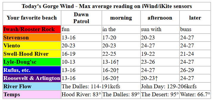
Friday kicked off with clear sky from the metro area to the desert (same as yesterday, when the Gorge inexplicably WAY over-performed!). Pressures at 7am were 29.97/29.88/29.85 for gradients of 0.09/0.03. Westerlies were generally in the 13-16mph range to start the day all the way from Stevenson to Arlington with Viento over-performing at 20-23mph. Models nudge the wind up to 22-25mph from Stevenson to Hood River, perhaps to Mosier by mid-morning.
In the afternoon, reinforcing “cool” air worms into the metro area, and temps soar in the desert. Westerlies build to 23-26mph, perhaps a bit more, from Stevenson to Rufus by mid-afternoon. In this time period, the Hatch is likely to dip to 19-22mph, but models bring it back in the evening when the entire zone from Stevenson to Arlington is forecast to build to 24-27mph. Between Rowena and Rufus, there’s a shot at 26-29mph this evening. Remember that this forecast predicts the iWind/iKite sensor readings, and they are not consistent – Swell reads low, so 20-23mph at Swell is equal to 26-29mph at Rufus and Arlington, and 30mph at Swell is equivalent to 35-38mph at Rufus and Arlington. Hope that helps! River flow over the last 24 hours was 11-1206kcfs, river temp is 66.7F, and high temp forecast is 83F and sunny.
RIVER FLOW FOR SITES BETWEEN AVERY (EAST OF THE DALLES) AND RUFUS: CLICK HERE FOR JOHN DAY DAM FLOW.
RIVER FLOW FOR SITES BETWEEN STEVENSON AND DOUG’S BEACH (WEST OF THE DALLES): CLICK HERE FOR THE DALLES DAM FLOW

LONGER-TERM gorge wind forecast
Saturday starts with low clouds to the west and sun to the east. Dawn Patrol forecast is 23-26mph from Viento to Mosier with 13-16mph at Stevenson and east of Mosier to Arlington. Thanks to a bunch of moving pieces in the atmosphere, an early morning lull is likely. By late morning, we’re back to 18-22mph from Stevenson to /Arlington. Afternoon wind builds to 20-23mph from Stevenson to Hood River with 22-25mph from Mosier to Rufus and 14-17mph at Arlington. High temp: 80F in Hood River and 90F in the desert.
Moving pieces are again in the cards for Sunday. Generally speaking, we should see 19-22mph from Stevenson to Hood River in the morning and 19-22mph from Stevenson to Doug’s in the afternoon. East of Doug’s, the wind will be under 10mph all day. High temp: 84F in Hood River.
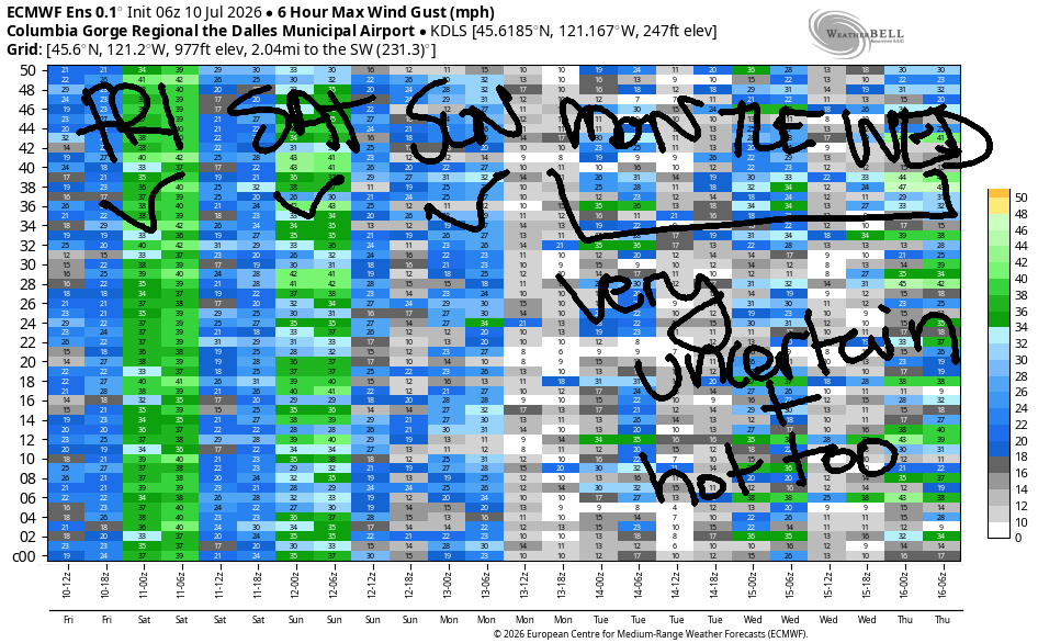
Model agreement lessens for Monday and Tuesday, but it does appear the westerlies will continue thanks to an onshore temp gradient. Looking at Wednesday and beyond, uncertainty rises. That said, ensembles are hinting that strong offshore high pressure will combine with a heat low in the desert for “classic Gorge setup” conditions – strong, relatively steady, all-day wind. Fingers crossed this plays out as currently forecast! See you on the Nch’i Wana soon!

Was that helpful? I knew it was! Guess what? All of this crucial work – from your personal wind and snow reports to the invaluable TATAS updates – is made possible by my relentless efforts. Maintaining this labor of love isn’t easy. Each daily forecast takes hours. Website hosting, weather model access, and back-end admin work takes time and money. That’s where you come in.
YOUR CONTRIBUTION MAKES A DIFFERENCE
- SUPPORT ACCURATE, HYPER-LOCAL WEATHER FORECASTING
- ENABLE ACCESS FOR ALL, EVEN THOSE WITH LESS MEANS
- SUPPORT A COOL HUMAN WHO WORKS HARD SO YOU CAN PLAY
Take a moment to click one of the buttons below. Donate $19.99 or more (how much does this forecast enhance your life?) and get the email in your inbox. Whether it’s a renewing subscription (auto-renew) or a one-time donation, every contribution makes a real difference. Help me keep this labor of love alive, so we can all continue playing, commuting, and living in the Gorge with peace of mind and the best weather forecasts possible. Thank you!


Hood River, Oregon 97031


JONES BEACH, SAUVIE ISLAND, & COAST FORECAST
Wind northerly unless otherwise indicated. For coast, it’s North/Central/South with the “central” at approximately Florence. Swell forecast from NWS for central coast. Jones: westerly unless otherwise stated. Sauvie Island: northerly unless otherwise stated.
Coast Friday: LTNW/LTNW/20-25, NW swell 4′ at 9 seconds. And SW 2′ @ 15. Saturday: LTW/LTW/15-20, NW 4′ @ 10 and SW 2′ @ 18. Sunday: 20/20/25-30, NW 5′ @ 9 and SW 2′ @ 14. Jones Friday: 17-20. Saturday: 12-15. Sunday: 19-22. Sauvie Island Friday: 14-17. Saturday: 12-15. Sunday: 12-15.
BARE BONES HOOD RIVER WEATHER FORECAST
Sunny all day. Temps start in the low 60s and rise to the low 80s. Moderately strong westerlies. No rainbows. Saturday will be partly cloudy then sunny. Temps start in the mid 50s and rise to 80. Moderately strong westerlies. No rainbows. Sunday will be partly cloudy then clear. Temps start in the mid 50s and rise to the mid 80s. Moderate westerlies. No rainbows.
TEMIRA’S AWESOME TRAVEL ADVISORY SERVICE
HYPERLOCAL WEATHER FORECAST FOR THE COLUMBIA GORGE
THE DALLES, HOOD RIVER, WHITE SALMON, TROUT LAKE, STEVENSON, CASCADE LOCKS, PARKDALE, ODELL, HUSUM, BZ, MILL A, WILLARD, GOLDENDALE, RUFUS, ARLINGTON, boardman
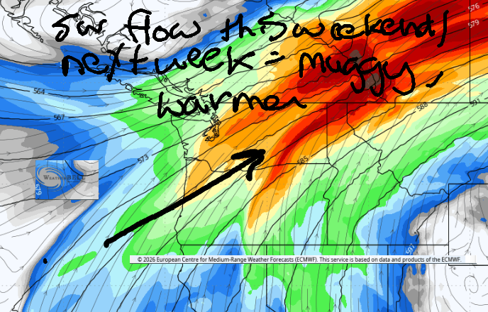
Good morning, neighbors! Perfectly “normal” weather continues for a few days, and then we enter a warming spell Monday. Hottest weather is likely to be on Tuesday (when it’ll be muggy, too!), but heat could persists into Wednesday and Thursday – model spread for the high temp on Thursday ranges from the mid 70s to near 100 for The Dalles! No rain is in sight for the next couple of weeks.
Glenwood and our friends around the world this morning
In Glenwood this morning, it was 46 degrees and sunny and folks were sitting around discussing what happened on their 20 minute calls with Mitch McConnell. When I talked to him yesterday, we discussed giant pumpkin growing and SUP foiling. He also stated he supports abolishing both !CE and billionaires; providing universal healthcare; 4 weeks of paid vacation; and teaching parenting skills to all high school youth. What did you discuss with him on your 20 minute call?
People in these places didn’t get to talk to Mitch as they’re too busy worrying about threats by other USA political figures. Even so, they continue to connect with friends and family and cultivate kindness and love. Hatred is never appeased by hatred in this world. By kindness alone is hatred appeased. This is a law eternal.” (Dhammapada 5)
Bandar-e Mahshahr, Iran: 113, sunny, 13% humidity
Havana, Cuba: 84, partly cloudy, 77% humidity
Muscat, Oman: 98, partly cloudy, 53% humidity
Caracas, Venezuela: 73, cloudy, 80% humidity
Nuuk, Greenland: 49, cloudy with showers, 84% humidity
Gaza City: 85, sunny, 60% humidity
Ottawa, Canada: 72, partly cloudy, 78% humidity
Today’s Gorge weather forecast
Here in the Gorge, it’ll be sunny today. Again! After a 55-65 degree start most places, we’ll reach 80+. Stevenson/Hood River/The Dalles/Pasco: 80/83/89/95. Nice onshore temp gradient there, eh? That gives us westerlies at 20-25mph west of Mosier this morning and 20-25mph as far east as Rufus this afternoon.
Saturday’s Gorge weather forecast
Low clouds push into the western Gorge on Saturday morning like a finger entering a consenting (oopsie, I’ll stop there)… Temps early in the morning will be 50-60 degrees. Afternoon brings 77/80/86/92, down a few degrees over Friday. The lowering of the temps is because Ma Nature too is less stressed on the weekend! West wind will be 15-20mph all the way from Stevenson to the Arlington Triangle in the morning. Afternoon: 20-25mph from Stevenson to Rufus and 20mph east of Rufus to the Triangle.
Sunday’s Gorge weather forecast
Sunday: 50-60 degrees to start (happy tomatoes). 81/84/89/90 to finish. Upper flow turns SW, and this initiates some clouds aloft – we’ll see a mix of mid and high clouds most of the day with plenty of sunshine too. West wind will be 15-20mph between Viento and Mosier in the morning and 15-20mph between Stevenson and The Dalles in the afternoon. To the east: light and variable.
Extended Gorge weather forecast
On Monday and Tuesday, we’ll see temps warm a bit more each day. West wind persists in the 15-25mph range. As the momentum of the southwest flow aloft builds, humidity will increase. Muggy weather is in the cards. Stake out a spot at a swimming hole for best results. Beyond Tuesday, model agreement falls apart. It’s unclear how long this hot spell will persist; that said, we should be back to seasonable, “normal”: weather by the end of next week. Safe travels. -TATAS
HEY! DON’T STOP READING! Is this community-focused forecast helpful to you? It sure is! It takes me a couple hours a day to write. Please join your friends and neighbors in contributing to keep it going. Venmo: @thegorgeismygym PayPal: twomirrors@gmail.com USPS: Temira / PO Box 841 / Hood River, Oregon 97031 You can test out the forecast subscription for a few days for free by signing up below. Easy! Do it!
MT HOOD SNOW FORECAST

QR codes and links for end-of-season tips – thank you!!!
Cash/check: Temira – PO BOX 841 – Hood River, Oregon 97031


Leave a Reply