

MT HOOD SNOW FORECAST

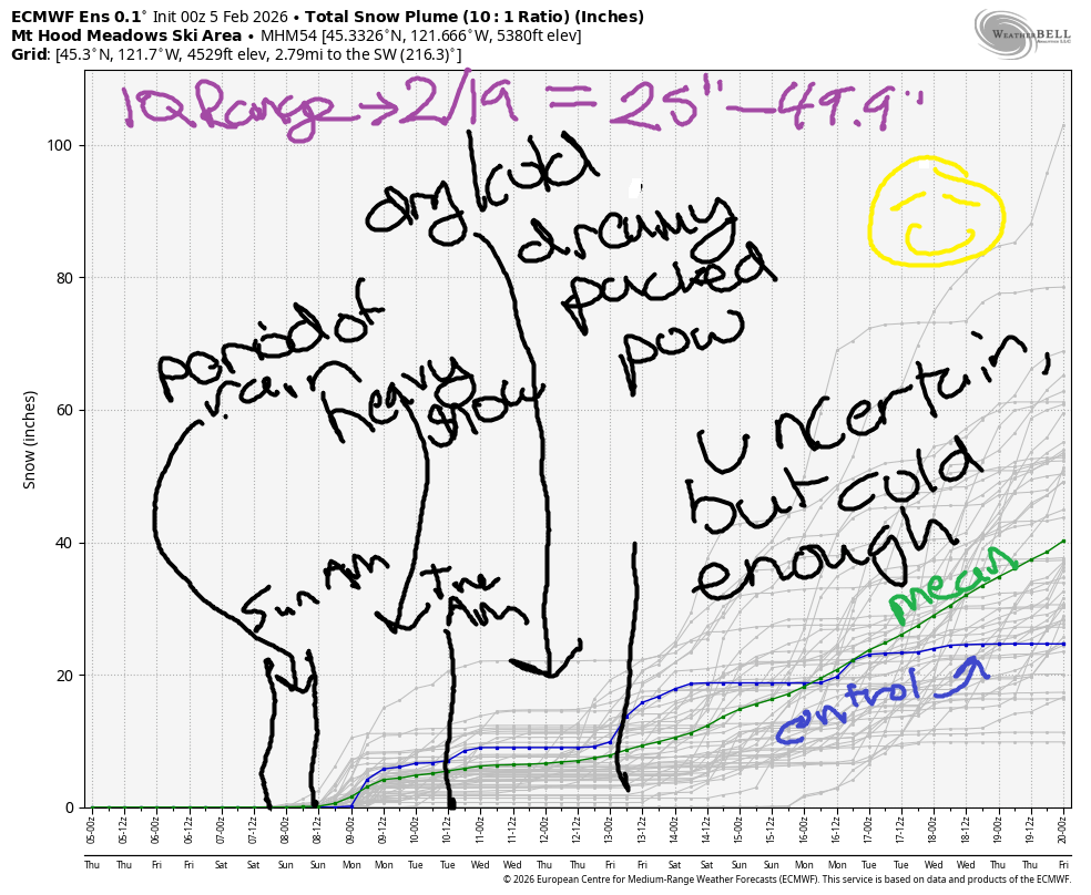
Hey skiers and snowboarders! Good news in the forecast! After a few more days of dry, warm weather, we fall into a colder, wetter pattern that extends all the way through the end of the two-week forecast period. While this pattern change will start with rain on Sunday morning, it’ll quickly switch to snow and stay snow. Generally speaking, we’ll have snow through Tuesday morning, a break for the mid to latter half of next week, and then a return back to cool, snowy weather through at least the 19th. The intraquartile range for snowfall through 2/19 is currently 25-49.9”.
Short term Mt Hood snow forecast
Looking at Thursday, we only have sunbeams falling from the sky. The free air freezing level will be well over 10,000′ all day. Temps at 5000′ max out in the low 50s. Wind will be SE 20-25 this morning, S 10-20 this afternoon, and W 5-10 overnight. Snow surface will be frozen granular early thanks to radiational cooling and spring conditions later. Wax: red or yellow depending on your timing.
Friday will be sunny to start with building high clouds in the afternoon. The free air freezing level starts around 11,000′ and falls to 9500′ in the afternoon before dropping to 8500′ after midnight. Temps max out in the upper 40s. Wind: W 5-10 in the morning, W 15 in the afternoon, and SW 15-25 overnight.
Extended Mt Hood Snow Forecast
Saturday will be sunny in the morning with filtered sun in the afternoon. Rain starts after midnight. The free air freezing level will be 9000′ all day, and the snow level will be around 8000′ when the precip arrives. Wind: SW 15-25 in the morning, SW 20-35 in the afternoon, and W 30 after midnight.
Rain early Sunday quickly gives way to snow mid-morning. The snow level will be 8000′ early, 4500′ mid-morning, and will slowly fall to 2000′ after midnight. Models are all over the place on rain and snow totals, but the mean snowfall in the ensembles is about 10” through Monday. That said, the GFS deterministic is much more optimistic: it likely the idea of 1.5-3.0 feet of snow. It’s probably an outlier. Looking farther out: we have continued snowfall through Tuesday morning, a dry period for the middle part of next week, and then a return to snow by late next week. We’ll parse out the details as we get closer. In the meantime, get up there and get some sun, because this may be the last of it for a while!
Was that helpful? I knew it was! Guess what? All of this crucial work – from your personal wind and snow reports to the invaluable TATAS updates – is made possible by my relentless efforts. Maintaining this labor of love isn’t easy. Each daily forecast takes hours. Website hosting, weather model access, and back-end admin work takes time and money. That’s where you come in.
YOUR CONTRIBUTION MAKES A DIFFERENCE
- SUPPORT ACCURATE, HYPER-LOCAL WEATHER FORECASTING
- ENABLE ACCESS FOR ALL, EVEN THOSE WITH LESS MEANS
- SUPPORT A COOL HUMAN WHO WORKS HARD SO YOU CAN PLAY
Take a moment to click one of the buttons below. Donate $19.99 or more (how much does this forecast enhance your life?) and get the email in your inbox. Whether it’s a renewing subscription (auto-renew) or a one-time donation, every contribution makes a real difference. Help me keep this labor of love alive, so we can all continue playing, commuting, and living in the Gorge with peace of mind and the best weather forecasts possible. Thank you!


Hood River, Oregon 97031


GORGE WIND FORECAST
If you’re still seeing yesterday’s and it’s after 9am, try opening this in an incognito window
SHORT-TERM gorge wind forecast
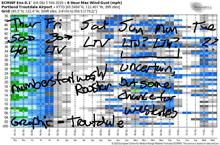
Hi friends! Nuking easterlies are in the works this morning, but they’ll start to fade this afternoon. Lesser east wind Friday morning turns calm in the afternoon. Not much happens on Saturday. There’s a slight chance of enough west wind late Sunday to get folks on the water at the Hatch, but models aren’t all that optimistic, and it’ll be raining. Light westerlies continue into Monday.
Thursday started with pressures of 30.15/30.39/30.40. Easterlies prior to dawn were reading 52mph at Iwash/Rooster, 35mph at Stevenson, and 23mph at Viento. Stevenson climbs to 35-40mph for a few hours mid-morning before slowly fading to 25-30mph by sunset. Iwash drops to 35-40mph this afternoon. River flow over the last 24 hours was 134-172kcfs, river temp is 40.6F, and high temp forecast is 50F with sun in the windy zones and Nothing elsewhere.
RIVER FLOW FOR SITES BETWEEN AVERY (EAST OF THE DALLES) AND RUFUS: CLICK HERE FOR JOHN DAY DAM FLOW.
RIVER FLOW FOR SITES BETWEEN STEVENSON AND DOUG’S BEACH (WEST OF THE DALLES): CLICK HERE FOR THE DALLES DAM FLOW

LONGER-TERM gorge wind forecast
Friday starts with 30-35mph at Iwash and 25mph at Stevenson. By afternoon, Stevenson will fall below 10mph and Iwash will turn light westerly. High temp: 53F with sunshine in the windy zones early and partly high overcast sky later.
A pattern change starts on Saturday. This leaves us with light and variable wind that turns westerly at 5-10mph near Stevenson in the afternoon. East of Hood River: dead calm. High temp: low 50s with Nothing early and clouds later. Sunday sees a cold front swing through with honest-to-goodness rain. At the tail end of this, west wind should return to the Gorge, but timing is unclear. If we get lucky, there will be a period of westerlies between Stevenson and the Hatch. Monday sees light west wind west of The Dalles with westerlies in the teens or low 20s out in the desert. That’s it for now. If you’re planning to go out, dress warmly, have an emergency plan, and keep an eye on your buddies!
BARE BONES HOOD RIVER WEATHER FORECAST
Nothing today. Temps start in the low 40s and rise to 50. Light to moderate easterlies. No rainbows. Friday will be Nothing then partly Nothing. Temps start in the mid 30s and rise to the low 50s. Light easterlies then dead calm. No rainbows. Saturday will be partly Nothing then cloudy. Temps start near 40 and rise to the mid 50s. Calm wind. No rainbows.
TEMIRA’S AWESOME TRAVEL ADVISORY SERVICE
HYPERLOCAL WEATHER FORECAST FOR THE COLUMBIA GORGE
THE DALLES, HOOD RIVER, WHITE SALMON, TROUT LAKE, STEVENSON, CASCADE LOCKS, PARKDALE, ODELL, HUSUM, BZ, MILL A, WILLARD, GOLDENDALE, RUFUS, ARLINGTON, boardman
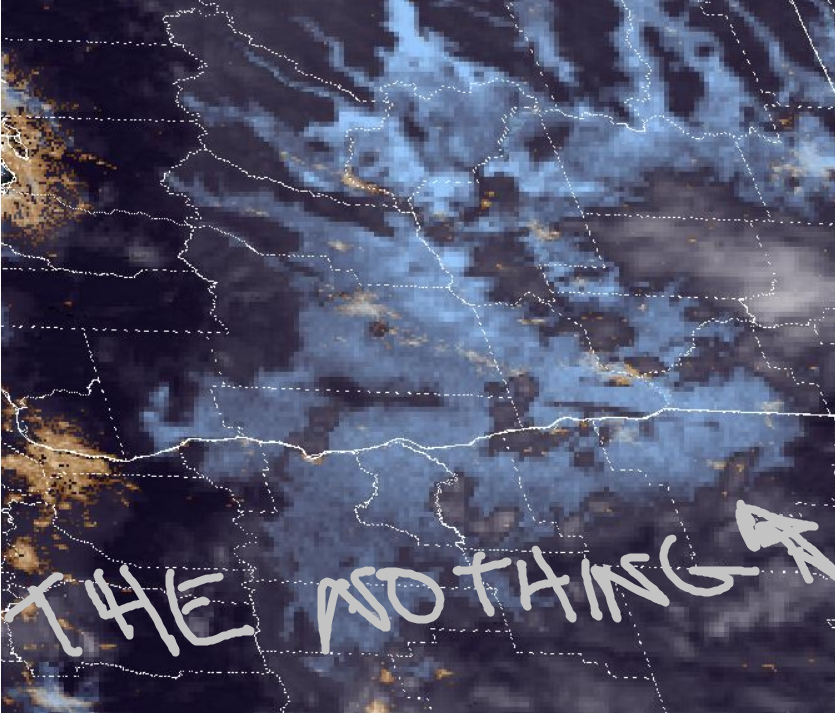
Good morning, neighbors! Nothing is running rampant over the Gorge this morning (it’s Thursday, btw). Look at the satellite photo for the extent of it. Given how much Nothing is around, it’s likely some folks in south Wasco and Sherman Counties have fog. Sorry about that!
Glenwood this morning
It appears we’re all above freezing this morning, even in and below the inversion. No !CE has been spotted on the roads. Glenwood was sitting at 35F this morning, and most of us were between 35F and 40F. Head up to 5000′ or higher for 45F and sunshine. Wait, did someone say “sun”? I’m outta here!
Today’s Gorge weather forecast
Okay, I’m not. Today brings a lasting Nothing. If you want sunshine, head west to the windy zones or up in elevation. Temps max out in the mid to upper 40s in the lowlands today and 50F on the sunny ski slopes. East wind will be 50mph this morning near Iwash (schlong) Rock and 35-40mph near Stevenson this morning before dropping to 35-40mph at Iwash (wiener) Rock and 25-30mph at Stevenson.
Friday’s Gorge weather forecast
The extend of the Nothing lessens Friday morning. Some of us may break out of it in the afternoon. The closer you are to the Nch’i Wana (Big River), the more likely you are to stay Nothing on Friday, unless you are west of Home Valley, in which case you should be sunny. Friday’s temps start just like today’s: 35-40F, and they finish near 50F.
Extended Gorge weather forecast
Saturday starts with partial Nothing, but many folks away from the Nch’i Wana will start with just some high clouds. By afternoon, lots and lots of clouds move in, and nobody is left sunny. Morning temps: 40F. Afternoon: 50-55F. Wind: light and variable.
RAIN (I’m excited hence the all caps) arrives late Saturday night or early Sunday morning. Timing: not set yet. Amount of rain: also not decided. It does appear the rain will be heavy enough for a messy city/country commute on Sunday, and it does appear we’ll get at least some rain in the Sunday-Monday time period all the way out into the desert. Up in the mountains, this starts as rain and transitions to SNOW by mid-morning Sunday. Expect snowy mountain passes perhaps Sunday, but definitely by Monday.
The longer-term forecast suggests a dry period Tuesday through next Friday (maybe some light rain) followed by a collapse into a cooler, wetter pattern that results in rain in the lowlands and snow (finally!) for the mountains. Safe travels. -TATAS
HEY! DON’T STOP READING! Is this community-focused forecast helpful to you? It sure is! It takes me a couple hours a day to write. Please join your friends and neighbors in contributing to keep it going. Venmo: @thegorgeismygym PayPal: twomirrors@gmail.com USPS: Temira / PO Box 841 / Hood River, Oregon 97031 You can test out the forecast subscription for a few days for free by signing up below. Easy! Do it!
JONES BEACH, SAUVIE ISLAND, & COAST FORECAST
ON WINTER VACATION UNLESS DESPERATELY NEEDED.