

MT HOOD SNOW FORECAST

QR codes and links for end-of-season tips – thank you!!!
Cash/check: Temira – PO BOX 841 – Hood River, Oregon 97031


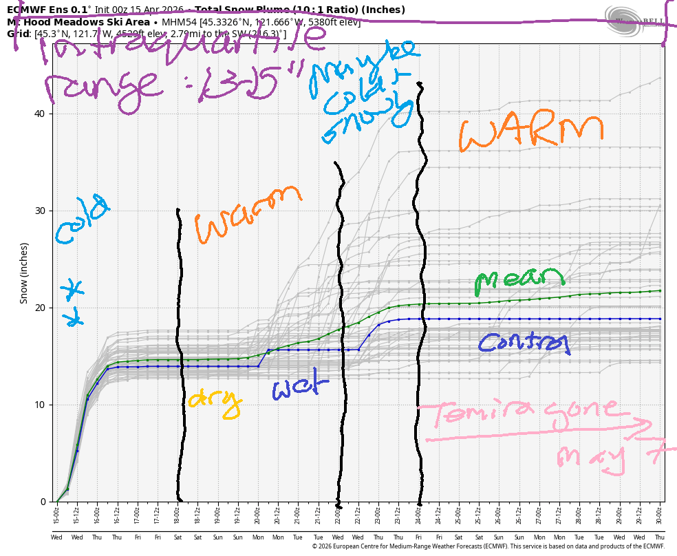
Hey skiers and snowboarders! In line with the weather this season, the overnight snowstorm under-performed some. That said, Timberline picked up 9” as of the time of this forecast. That’s a nice addition to the snowpack. I looked at the Meadows Nordic cam, and it’s snowy down there too. Be prepared for a snowy drive to the mountains today!
Short term Mt Hood snow forecast
Heavy snow this morning gives way to a break midday and another round of moderate snowfall tonight. The snow level will be around 2000′ all day. The freezing level falls as low as 1000′ overnight. For the morning, we’re expecting another couple inches of snow. For the afternoon, a couple inches additional snow. Models give us a shot at another 0.5” water equivalent (WE) overnight thanks to orographic (terrain) assistance. I’d be surprised if we receive that much precip. Let’s call it 2-5” overnight to account for the luckiest possible outcome. Wind today will be WNW 30-35 all day and NW 25-30 after midnight. Snow surface will be powder and packed powder (yay). Temps max out in the upper 20s this morning before falling to the low 20s overnight.
Thursday starts off clear and cool with temps in the low 20s. The free air freezing level will be 1000′ early, 2500′ in the afternoon, and 1000′ after midnight. Wind will be NW 25-30 early, WNW 25-30 in the afternoon, and WNW 15-20 after midnight. Snow surface: packed powder.
Extended Mt Hood Snow Forecast
Friday will be sunny. The free air freezing level starts at 1000′ and rises to 5000′ in the afternoon. Overnight, it climbs to 6000′. Morning temps will be in the low-mid 20s, but temps will rise to the mid-upper 30s by afternoon. Get it early for best results. Wind will be WNW 15-20 in the morning, light and variable in the afternoon, and S 5-15 after midnight.
Saturday looks warm (50 degrees) and sunny with light south wind. Sunday looks high overcast and warm (50+ degrees) with light to moderate south wind. Beyond that… there’s too much uncertainty in the models to make any precision forecasts. The last day for this snow forecast this season will be Friday. Please consider making an end-of-season tip if you’ve found this helpful, especially if you’re reading this on the website and haven’t yet supported!
Was that helpful? I knew it was! Guess what? All of this crucial work – from your personal wind and snow reports to the invaluable TATAS updates – is made possible by my relentless efforts. Maintaining this labor of love isn’t easy. Each daily forecast takes hours. Website hosting, weather model access, and back-end admin work takes time and money. That’s where you come in.
YOUR CONTRIBUTION MAKES A DIFFERENCE
- SUPPORT ACCURATE, HYPER-LOCAL WEATHER FORECASTING
- ENABLE ACCESS FOR ALL, EVEN THOSE WITH LESS MEANS
- SUPPORT A COOL HUMAN WHO WORKS HARD SO YOU CAN PLAY
Take a moment to click one of the buttons below. Donate $19.99 or more (how much does this forecast enhance your life?) and get the email in your inbox. Whether it’s a renewing subscription (auto-renew) or a one-time donation, every contribution makes a real difference. Help me keep this labor of love alive, so we can all continue playing, commuting, and living in the Gorge with peace of mind and the best weather forecasts possible. Thank you!


Hood River, Oregon 97031


GORGE WIND FORECAST
If you’re still seeing yesterday’s and it’s after 9am, try opening this in an incognito window
SHORT-TERM gorge wind forecast
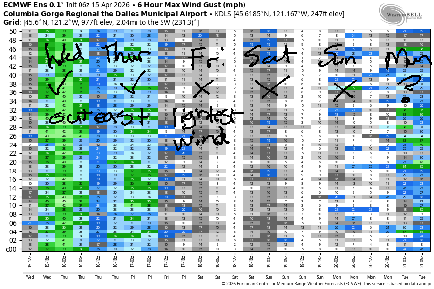
Hi friends! A couple more days of eastern Gorge westerlies are on tap. Starting Friday, we fall into a light wind pattern that (probably) persists all the way through the weekend. That should give you a chance to switch from river sports to mountain biking – the dirt is going to be perfect after this morning’s rain!
Wednesday started with pressures of 29.82/29.72/29.69 for gradients of 0.10/0.03. While that seems to indicate a Corridor day, it’s not – best results will be found out east this afternoon. Early this morning, we’ll have gusty 10-15mph from the hatch east. It appears the front is approaching, because as I was writing this, readings from Stevenson to Viento were 22-25mph. As the system moves through, we’ll see a slow and steady build out east. Avery to Arlington rises to 22-25mph mid-morning and keeps climbing.
By mid-afternoon, you’ll find gusty 27-30mph from Avery to Threemile. Instability after 2pm could impact wind quality and reliability. Your best chance late afternoon appears to be east of Rufus. There may also be a period of mid-afternoon, very-gusty, 21-24mph from Stevenson to Doug’s preceding an incoming system that will bring rain with it. River flow over the last 24 hours was 188-218kcfs (209-213kcfs at Rufus), river temp is 50.5F, and high temp fo9recast is just 51F in Hood River and 58F in the desert. Clouds persist for most of the day.
RIVER FLOW FOR SITES BETWEEN AVERY (EAST OF THE DALLES) AND RUFUS: CLICK HERE FOR JOHN DAY DAM FLOW.
RIVER FLOW FOR SITES BETWEEN STEVENSON AND DOUG’S BEACH (WEST OF THE DALLES): CLICK HERE FOR THE DALLES DAM FLOW

LONGER-TERM gorge wind forecast
Robust high pressure builds offshore on Thursday and sets us up for a steadier, more reliable day of westerlies. Early wind will be gusty 13-16mph under cloudy sky west of Mosier with 20-23mph from Mosier to Rufus and lighter wind out east. Midday brings gusty 15-18mph from Stevenson to Hood River 27-30mph from Mosier to Rufus. Hang on a little longer, and you’ll be rewarded with 25-28mph from Mosier to Doug’s and 29-32mph from Avery to Arlington. Threemile tops out around 20-23mph. Areas west of Mosier are unlikely to make it consistently above 20mph due to lingering clouds. High temp: 54F in Hood River and 60F with partly cloudy sky in the desert.
High pressure builds inland on Friday and basically shuts down the wind. It could be as strong as 10mph near Stevenson early and late, but midday looks close to calm. High temp: 60F with low clouds early and high clouds later.
For the weekend, we’ll have a low pressure system spinning off the coast. This gives us light and variable wind on Saturday and light westerlies on Sunday. Uncertainty increases on Monday. While there are some indications of moderately strong to strong westerlies next Tuesday and Wednesday, that’s way too far out to be making reliable predictions. Have fun on the river the next couple of days!

BARE BONES HOOD RIVER WEATHER FORECAST
Rain early. Dry for a couple hours. Showery this afternoon. Temps start in the mid 40s and rise to the low 50s. Light to moderate westerlies. 99% chance of rainbows. Thursday will be cloudy early then mostly sunny. Temps start in the mid 30s and rise to the mid 50s. Moderate westerlies. 1.5% chance of rainbows. Friday will be cloudy then partly cloudy then cloudy overnight. Temps start in the mid 30s and rise to 60. Light westerlies becoming calm. No rainbows.
TEMIRA’S AWESOME TRAVEL ADVISORY SERVICE
HYPERLOCAL WEATHER FORECAST FOR THE COLUMBIA GORGE
THE DALLES, HOOD RIVER, WHITE SALMON, TROUT LAKE, STEVENSON, CASCADE LOCKS, PARKDALE, ODELL, HUSUM, BZ, MILL A, WILLARD, GOLDENDALE, RUFUS, ARLINGTON, boardman
Good morning, neighbors! Happy Irrigation Day! May the water be turned on in a timely manner, and may it be copious all summer long! Naturally we picked up 0.25” rain in Hood River on the day they (might) turn on the water. But hey, any rain is good rain except when the blossoms are open (fire blight risks) and the cherries are near ripening (splitting risk). Speaking of risk, there’s some risk of frost/freeze Thursday and Friday mornings.
Glenwood this morning
Let’s start with the risk of sub-freezing temps in Glenwood this morning. That risk is ZERO. It’s 40 degrees there, and everyone is shaking their heads in wonder at just how damn warm this winter was.
Today’s Gorge weather forecast
Nobody will be saying that today’s high temps are warm. In the lowlands, we max out around 50F in the west, 54F near The Dalles, and 58F in the desert. After this morning’s system swings through, we’ll have a break from the rain. In the afternoon, a system moves in from the west with showers and a slight chance of hail in the heaviest showers. That rain should stay (mostly) west of The Dalles and west of the Cascade Crest. With temps aloft at -5C, it’s possible we could see a little wet snow mix in above 1000-1500′, but sticking snow is unlikely in our inhabited zones. The story is different on the passes: they’re snowy. Keep that in mind if you’ll be crossing them today. Wind today will be 15mph give-or-take west of The Dalles and 25-35mph from The Dalles eastward to Threemile Canyon.
Thursday’s Gorge weather forecast
Overnight into Thursday, showers end and clouds start to break up. Nobody likes a breakup, and same goes for us and our relationship with the clouds: the more the clouds break up, the colder it will be on Thursday morning. Frost discussion: dewpoints drop below 32F, 850mb temps fall to -5/-6C, NW wind persists, and low clouds struggle to fully dissipate prior to dawn. Above 1500′, temps are likely to be below 32F due to those cold temps aloft. For the rest of us, frost potential really depends on wind and sky coverage. Near the Nch’i Wana (big river), there’s going to be enough west wind to keep temps above freezing. Sheltered valleys east of Hood River (where clouds are less likely) could see sub-freezing temps. Parkdale is really tricky due to the possible cloud coverage; if it’s cloudy, we’re looking at 32-36F. If the clouds break up, we’re looking at 27-31F.
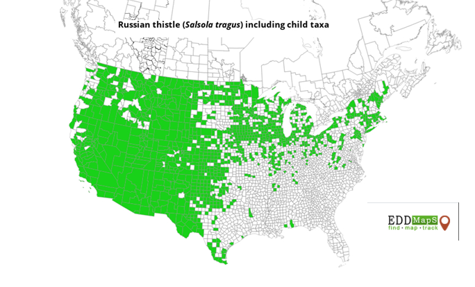
Rest of Thursday’s news…. We finish with partly cloudy sky west of The Dalles, mostly sunny sky near The Dalles, and partly cloudy sky to the east. West wind will be 15-20mph west of Mosier all day with 25-35mph westerlies from Mosier east to Arlington’s Isosceles Triangle in the afternoon. This results in Wind Johnnies zipping around like ants whose nest has been disrupted. Temps max out in the mid 50s from The Dalles westward and rise to 60 degrees in the desert, where the tumbleweeds are going to be very, very happy with all the wind. Nothing like an invasive Siberian/Russian plant (first introduced in South Dakota in 1873) continuing to distribute itself across the States. See – Russia IS messing with us! (see map for tumbleweed prevalence)
Friday’s Gorge weather forecast
Friday morning looks cloudy to the west and mostly clear to the east which leaves us with another frost possibility. Once again, temps aloft will be -5C. We’ll have light wind (bad sign) and dewpoints in the 20-29F range. Frost is probably more likely Friday than on Thursday thanks to the overall setup, but we still may have enough clouds west of Mosier to provide some insulation. By Friday afternoon, we’ll switch to high clouds and light wind with temps in the low 60s.
Extended Gorge weather forecast
Saturday looks warmer with light and variable wind. Highs will be SIX-SEVEN to the west and 70F to the east. Slightly warmer weather is forecast on Sunday with light west wind. Beyond that – too much uncertainty to pinpoint the outcomes. There is some chance of another round of chilly weather next Wednesday-Thursday. Beyond that, frost chances look minimal through the end of the month. Safe travels. -TATAS
HEY! DON’T STOP READING! Is this community-focused forecast helpful to you? It sure is! It takes me a couple hours a day to write. Please join your friends and neighbors in contributing to keep it going. Venmo: @thegorgeismygym PayPal: twomirrors@gmail.com USPS: Temira / PO Box 841 / Hood River, Oregon 97031 You can test out the forecast subscription for a few days for free by signing up below. Easy! Do it!
JONES BEACH, SAUVIE ISLAND, & COAST FORECAST
ON WINTER VACATION UNLESS DESPERATELY NEEDED.
