

GORGE WIND FORECAST
If you’re still seeing yesterday’s and it’s after 9am, try opening this in an incognito window AND/OR FLUSHING YOUR CACHE or do a do a hard refresh (Ctrl+Shift+R / Cmd+Shift+R)
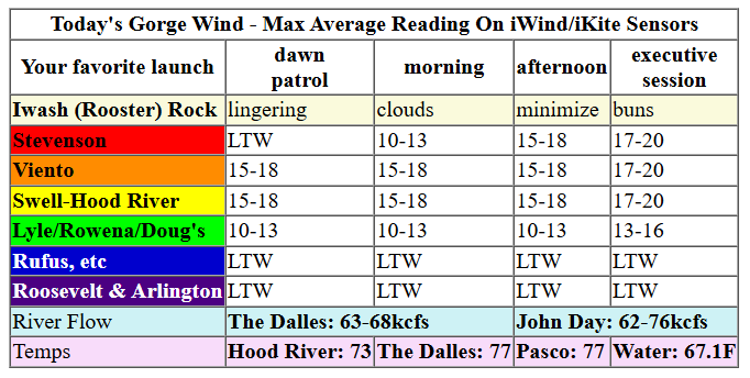
Keep in mind that this forecast attempts to predict what the iKite/iWind sensors will read. Think like a local! All sensors are not equal. Swell reads low. Viento/Arlington/The Wall read high compared to Swell. 30mph at Rufus (The Wall sensor) is about 23-24mph at Swell. 30mph at Swell is about 35-37mph at Rufus/Viento/Arlington. Hope that helps!
SHORT-TERM gorge wind forecast

Hi friends! It was so lovely to be out on the river with you AGAIN yesterday. I got myself one MASSIVE run from T5 to the Hatch. Today, Wednesday, brings moderate westerlies. It’s possible we’ll have another similar round late Thursday, but it’s questionable. On Friday, a low pressure system likely moves inland and likely sets off a round of strong desert easterlies, but details are still uncertain. It’s very likely we’ll switch to east wind for the weekend.
This morning, Wednesday, started with pressure of 30.11/30.04/30.04 for gradients of 0.07/0.00. That’s a good sign you should stay west of The Dalles. Most of the day brings westerlies at 15-18mph from Viento to the Hatch with under 10mph everywhere else. Stevenson eventually joins. After 5pm, there’s a chance of 17-20mph from Stevenson to Hood River with 13-16mph from Mosier to Doug’s. River flow over the last 24 hours was 62-76kcfs, river temp is 67.1F, and high temp forecast is 73F.
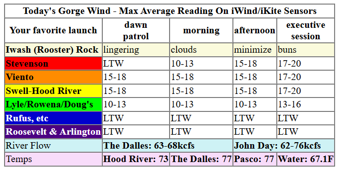
RIVER FLOW FOR SITES BETWEEN AVERY (EAST OF THE DALLES) AND RUFUS: CLICK HERE FOR JOHN DAY DAM FLOW.
RIVER FLOW FOR SITES BETWEEN STEVENSON AND DOUG’S BEACH (WEST OF THE DALLES): CLICK HERE FOR THE DALLES DAM FLOW

LONGER-TERM gorge wind forecast
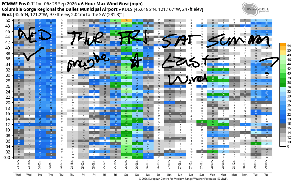
Thursday sees very active weather with unreliable wind. Thanks to a low offshore, there’s a chance of a couple hours of 15-20mph at Stevenson, Home Valley, and Viento early to mid-morning. As the weather system approaches late afternoon, we could see westerlies build to 20ish mph from Stevenson to Avery, but no promises. High temp: 74F in Hood River.
Friday has big potential, but also lots of uncertainty. Models bring a low pressure system inland, but they’re uncertain about the the strength of the low or its track. Behind it: high pressure builds offshore. This is generally a good setup and should favor areas east of The Dalles. West of The Dalles, showers and clouds will linger for very gusty, but still windy conditions. For now, all I can say is 25-35mph with equal chances at both ends of that range. We’ll keep a close eye on it!
Saturday brings light easterlies, and Sunday brings stronger easterlies. That’s all I’ve got for you now. See you on the Nch’i Wana soon!
Tip via venmo, cash or check
Want to subscribe to the email version, support Temira, and get the forecast earlier? Click on the blue box up above or use the methods below. Year-round is $29.99 or more if you think it’s worth more. Only need snow or only need wind? Warm season (May-Oct) or cold season (Nov-Apr) is $19.99 or more if you think it’s worth more. Thanks for your support!

JONES BEACH, SAUVIE ISLAND, & COAST FORECAST
Wind northerly unless otherwise indicated. For coast, it’s North/Central/South with the “central” at approximately Florence. Swell forecast from NWS for central coast. Jones: westerly unless otherwise stated. Sauvie Island: northerly unless otherwise stated.
Coast Wednesday: 20/15-20/25, NW swell 6′ @ 11 seconds and SW 2′ @ 15. Thursday: E15/SE15-20/S20-25, NW 6′ @ 11 and SW 2′ @ 15. Friday: WNW15/LTNW/N20, NW 6′ @ 10 and SW 3′ @ 14. Jones Wednesday: 7-10. Thursday: LTV. Friday: 10-13. Sauvie Island Wednesday: 10-13. Thursday: 7-10. Friday: SW30 → W 15.
BARE BONES HOOD RIVER WEATHER FORECAST
High overcast this morning. Partly high overcast this afternoon. Temps start in the upper 50s and rise to the low 70s. Light westerlies early. Moderate later. No rainbows. Thursday will be partly high overcast, then cloudy, then rainy overnight. Temps start in the upper 40s and rise to the mid 70s. Light westerlies early. Moderate later. 11% chance of rainbows. Friday will be rainy, then showery, then dry in the afternoon. Temps start in the low 50s and rise to the low 60s. Light and variable wind early. Strong westerlies in the afternoon. 99% chance of rainbows.
BIKE TRAILS INFO
NEXT WORK PARTY: HRATS work parties Sunday October 25th and Sunday November 8th.
CLOSED TRAILS: Anything south of the 44 Road due to the Grasshopper Fire / Forest Closure Order: for example – Boulder Lakes, Gunsight, Gumjuwac, Lookout Mountain, 450, Fifteenmile. All Green Mountain lands: Underwood Mountain, Whoopdee Trail. Kreps lands, aka Hospital Hill, are closed due to fire danger. Gates are closed in Post Canyon due to fire danger.
TEMIRA’S AWESOME TRAVEL ADVISORY SERVICE
HYPERLOCAL WEATHER FORECAST FOR THE COLUMBIA GORGE
THE DALLES, HOOD RIVER, WHITE SALMON, TROUT LAKE, STEVENSON, CASCADE LOCKS, PARKDALE, ODELL, HUSUM, BZ, MILL A, WILLARD, GOLDENDALE, RUFUS, ARLINGTON, boardman

Good morning, neighbors! Dang – it is a heck of a nice morning for gardening! Heck, it’s a heck of a nice morning for a lot of things. Get out there and do something! Not much happens today as a dry system swings through. Rain is forecast Thursday night into Friday, when the snow level will fall to 5500′ or so and the volcanoes should pick up several inches, at least. Down here on Friday: about a 70% chance of super windy conditions. Cooler, calmer, sunnier weather is forecast for the weekend when our coldest spots have a chance of frost.
It is not frosty in Glenwood this morning – it was only 38 degrees there. Since it wasn’t frosty, you should make frosting (cream cheese) and deliver it to me atop cinnamon rolls. Or just eat the cinnamon rolls from Cousin’s. For the rest of today (Wednesday, hump day), clouds decrease some but don’t totally clear. Temps rise to 71 in Stevenson, 73 in Hood River, and 77 from The Dalles eastward. Wind rises to 15-20mph from Stevenson to Hood River this afternoon with 10-15mph from Mosier to The Dalles. To the east: light wind.
On Thursday morning, an upper level low (ULL, not quite like Ullr, but it will bring snow to the mountains) coalesces off the coast. It taps into a bit of tropical moisture. How much isn’t clear, and nor is the strength or inland path of the low. All that said, we’ll have a partly high overcast, 40-55 degree start to Thursday. Clouds increase. Temps stop out between 74 and 78. Wind will be light and variable in the morning with a period of E 15-20mph possible for a couple hours near Stevenson and Cascade Locks – HOLD ON TO YOUR ICE CREAM CONES! Afternoon wind builds from the west to 15-25mph between Stevenson and Avery. Or maybe not. Depends on the timing and strength of the low.
Rain arrives late Thursday evening: 8pm west of Wyeth and 11pm to Celilo Village. After midnight, the rain field shifts east and wets everyone (including Arlington’s Triangle) all the way to the Tri-Cities early Friday morning. At this point, the snow level falls to 5500′ or so. As the low moves inland during the day Friday (probably), we’ll have blasting west wind (probably). Depends on the strength and location of the low. Just ahead of it, we’ll have a period of heavy rain west of Rowena, probably in the 8am-11am window. Afternoon: showery, windy, and full of rainbows. Morning temps: 45-55. Afternoon: 59/61/67/71.
Everything calms down Friday night into Saturday morning. Long night + calm wind + dewpoint 29-34 + clear sky + 850mb temp at +2 to +4C = slight chance of frost in Glenwood and a good chance of fog/Nothing many other places. Rest of Saturday: light east wind, sunny, 64-68 degrees.
On Sunday morning, we may have a few high clouds, but probably not thick enough to act as a blanket. Dewpoints fall to 26-37 for a slightly better chance of frost and an equal chance of a Nothing cloud near the Nch’i Wana. Highs: 64-71. Cool weather, under 75 degrees, continues into next week with additional chances of rain (not certain, but possible!) from the middle of the week on. Safe travels. -TATAS
HEY! DON’T STOP READING! Is this community-focused forecast helpful to you? It sure is! It takes me a couple hours a day to write. Please join your friends and neighbors in contributing to keep it going. Venmo: @thegorgeismygym PayPal: twomirrors@gmail.com USPS: Temira / PO Box 841 / Hood River, Oregon 97031

MT HOOD SNOW FORECAST

QR codes and links for end-of-season tips – thank you!!!
Cash/check: Temira – PO BOX 841 – Hood River, Oregon 97031