

GORGE WIND FORECAST
If you’re still seeing yesterday’s and it’s after 9am, try opening this in an incognito window AND/OR FLUSHING YOUR CACHE or do a do a hard refresh (Ctrl+Shift+R / Cmd+Shift+R)
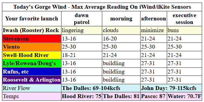
Keep in mind that this forecast attempts to predict what the iKite/iWind sensors will read. Think like a local! All sensors are not equal. Swell reads low. Viento/Arlington/The Wall read high compared to Swell. 30mph at Rufus (The Wall sensor) is about 23-24mph at Swell. 30mph at Swell is about 35-37mph at Rufus/Viento/Arlington. Hope that helps!
SHORT-TERM gorge wind forecast

Hi friends! Hopefully you caught some of yesterday’s wind (reports are that the swell was good at the Hatch!), because there’s not much happening through the weekend. There’s some chance of a little pre-frontal wind today before the rain starts, but that’s not a promise. Next sizable chance of wind isn’t until Monday.
Wednesday started with pressures of 29.81/29.79/29.74 for light onshore gradients (0.02/0.05). Westerlies early this morning were generally running about 10mph. As a strong cold front moves inland today, we’re likely to see a burst of wind just ahead of it. This sort of wind tends to be up-and-down and short-lived (60-90 minutes), but if you’re in the right place at the right time, you might get lucky. No promises.
Total guess on speed: gusty 18-23mph, first at Stevenson, then at Viento (where it might be much windier for a bit, because Viento), then at the Hatch… then moving into the more eastern locations ahead of the rain. When the rain arrives, the wind will drop below 10mph. River flow over the last 24 hours was 73-93kcfs, river temp is 70.3F, and high temp forecast is 65F with rain after noon.

RIVER FLOW FOR SITES BETWEEN AVERY (EAST OF THE DALLES) AND RUFUS: CLICK HERE FOR JOHN DAY DAM FLOW.
RIVER FLOW FOR SITES BETWEEN STEVENSON AND DOUG’S BEACH (WEST OF THE DALLES): CLICK HERE FOR THE DALLES DAM FLOW

LONGER-TERM gorge wind forecast
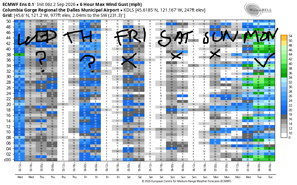
Thursday brings showery weather and not much wind. There’s a slight possibility of some afternoon wind east of The Dalles. For the morning: light westerly, then easterly at 15mph for a couple hours near Stevenson and Viento, then westerly at 10mph west of The Dalles. Between Avery and Arlington, there’s a chance of gusty 18-21mph after 2pm. Also forecast: atmospheric instability and surface-based thunderstorms in the afternoon. This scenario would result in unreliable wind. High temp: 62F in Hood River and 69F in the desert.
Friday starts with easterlies at 15-20mph at Iwash (Rooster) Rock, Stevenson, and potentially Viento. The wind lasts a few hours and then goes calm by midday. Once again, we’ll have atmospheric instability and showers with highs from 67-72 degrees.
For the weekend, models give us light and variable wind both days. Lots of uncertainty is present for Monday, but a decent percentage of the Euro ensemble, and the GFS deterministic, give us westerlies at 20mph or more. Fingers crossed. In the meantime, mountain bike season is about to get good! Get out there and enjoy all the not-wind stuff the Gorge has to offer!
Tip via venmo, cash or check
Want to subscribe to the email version, support Temira, and get the forecast earlier? Click on the blue box up above or use the methods below. Year-round is $29.99 or more if you think it’s worth more. Only need snow or only need wind? Warm season (May-Oct) or cold season (Nov-Apr) is $19.99 or more if you think it’s worth more. Same for the cold season forecast. Thanks for your support!

JONES BEACH, SAUVIE ISLAND, & COAST FORECAST
Wind northerly unless otherwise indicated. For coast, it’s North/Central/South with the “central” at approximately Florence. Swell forecast from NWS for central coast. Jones: westerly unless otherwise stated. Sauvie Island: northerly unless otherwise stated.
Coast Wednesday: S30-40/S30-40/S30-40, W swell 5′ @ 6 seconds and SW 10′ at 9. Thursday: Variable to 15/S20-25/S20, S 5′ @ 6 and NW 9 @ 11. Friday: LTV/LTV/LTV, W 6′ @ 10 and SW 3′ @ 17. Jones Wednesday: LTE. Thursday: LTV. Friday: LTV. Sauvie Island Wednesday: 15-18. Thursday: S15. Friday: LTV.
BARE BONES HOOD RIVER WEATHER FORECAST
Mostly cloudy this morning and rainy after noon. Temps start in the low 60s and rise to the mid 60s. Light westerlies with a brief period of stronger west wind ahead of the rain. 19% chance of rainbows. Thursday will be drizzly early then showery. Temps start in the upper 40s and rise to the low 60s. Light and variable wind. 99% chance of rainbows. Friday will be cloudy early and showery in the afternoon. Temps start in the upper 40s and rise to six-seven degrees. Light easterlies early. Calm wind later. 98% chance of rainbows.
BIKE TRAILS INFO
NEXT WORK PARTY: August 15th and September 5th on the 133 trail in Post Canyon. Meet at Post Flats Staging Area at 9am. Hosted by Hood River County.
CLOSED TRAILS: Anything south of the 44 Road due to the Grasshopper Fire / Forest Closure Order: for example – Boulder Lakes, Gunsight, Gumjuwac, Lookout Mountain, 450, Fifteenmile. ALL GREEN MOUNTAIN LANDS: Underwood Mountain, Whoopdee Trail. Kreps lands: Hospital Hill. All the gates in Post Canyon are closed due to fire danger.
TEMIRA’S AWESOME TRAVEL ADVISORY SERVICE
HYPERLOCAL WEATHER FORECAST FOR THE COLUMBIA GORGE
THE DALLES, HOOD RIVER, WHITE SALMON, TROUT LAKE, STEVENSON, CASCADE LOCKS, PARKDALE, ODELL, HUSUM, BZ, MILL A, WILLARD, GOLDENDALE, RUFUS, ARLINGTON, boardman
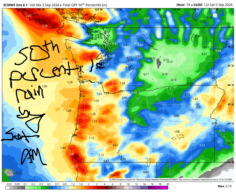
Good morning, neighbors! RAIN IS COMING! How exciting! We’re all going to get wet today. On Thursday and Friday, instability and possible thunderstorms add to the rain totals. Hopefully we’ll avoid any hail, or at least any hail falling on the orchards. Cool temps persist through at least Sunday, and then we’re gifted with a middling warm-up next week. Fishing people: for a good portion of this period, the wind will be quite light!
It is Wednesday, aka HUMP DAY. Hump is a synonym for a bump, and it’s also a synonym for intercourse, aka “s*x”. You should do some of that today to celebrate reaching the middle of the week! Weather today becomes increasingly cloudy and increasingly wet. Rain reaches Cascade Locks this morning, Hood River by noon, and the Arlington Triangle (and beyond) by early to mid afternoon. Rain will be heavy west of Rowena this afternoon, heavy enough to instigate hydroplaning and high-speed windshield wiper activation. Wind: light and variable becoming westerly at 20mph just ahead of the incoming rain. High temps range from 65 in Hood River to 71 in The Dalles and 77 in Pasco. Snow level: 8000′
Overnight, we’ll have a short period of dry weather followed by an additional round of light rain as far east as The Dalles around sunrise. Morning temps: 45-55. Partly cloudy sky combines with cold air aloft for atmospheric instability Thursday afternoon. Showers, thundershowers, and small hail are all possible but will be mostly confined to areas west of The Dalles. Wind will be light early, easterly at 15mph near Stevenson mid-morning, and westerly in the afternoon: 10mph west of The Dalles and 15-20mph between Avery and Rufus. Highs; 67-72 degrees. Snow level: 6500′.
Friday starts chilly: 40-55 degrees with partly cloudy sky and the possibility of some drizzle west of Avery. Afternoon: just like Thursday – showery, thundershowery, hail-y with temps at 67-72 degrees. Snow level: 6500-7000′. Wind will be E 15-20mph early at Iwash (dong) Rock, Stevenson, and Viento. Afternoon brings calm wind. For the weekend, we’re looking at low to mid 70s, partly cloudy sky, and light/variable wind. That’s all I’ve got for you for now. I gotta run and pick all my ripe/blushing peppers and tomatoes before the rain arrives. Safe travels. -TATAS
HEY! DON’T STOP READING! Is this community-focused forecast helpful to you? It sure is! It takes me a couple hours a day to write. Please join your friends and neighbors in contributing to keep it going. Venmo: @thegorgeismygym PayPal: twomirrors@gmail.com USPS: Temira / PO Box 841 / Hood River, Oregon 97031
MT HOOD SNOW FORECAST

QR codes and links for end-of-season tips – thank you!!!
Cash/check: Temira – PO BOX 841 – Hood River, Oregon 97031