


Thank you for using this forecast. Like it? Find it useful? Support it (and me!) by sending some cash my way. What’s it cost to support me and get the email version? Not $99 a year. Nope. Not $49. Just $19.99 or more gets you a year. People are added to this list on Thursday and Sunday. My day job is crisis mental health, and I don’t have time on other days. Thanks for your patience! Click below to contribute. Thank you!!
 |
|
 |
Thank you for contributing and keeping this forecast going! Not ready to subscribe? No problem – please share this forecast with all your friends too! I appreciate your support!
The Forecast
| Your favorite beach | Dawn Patrol |
9am- 11:30a |
11:30a- 3pm |
3pm- dusk |
|
|---|---|---|---|---|---|
| Iwash (Rooster) Rock | LTW | LTW | LTW | LTW | |
| Stevenson | G20ish | G20ish | G14-17 | G14-17 | |
| Viento | G20-25 | G20-25 | G14-17 | G14-17 | |
| Swell-Hood River | G14-17 | G14-17 | G14-17 | G14-17 | |
| Lyle to Doug’s | LTW | LTW | G14-17 | G14-17 | |
| Rufus, etc. | G14-17 | G14-17 | G25-29 | G25-29 | |
| Roosevelt & Arlington | G14-17 | G14-17 | G25-29 | G25-29 | |
Gorge Wind Forecast
 Hi wind Johnny friends! Today’s our best chance for westerlies for the next couple of weeks. If you want it, get on it! At 6am, pressures were 29.98/29.90/29.85 for gradients of 0.08 and 0.05. Viento was averaging 25. It’ll drop to 14-17 after this weather system moves through. Out east, speeds were in the 15-20mph range prior to dawn. By late morning, locations from Avery to Arlington should ramp up to 25-29. Threemile: 22-25. The wind starts to fade early afternoon and drops to 22-25 from Avery to Arlington. Driving pre-emptively might be a good idea today.
Caveats and further discussion: ensembles are still all over the place on wind speeds today; they give approximately a 40-50% chance of GUSTS exceeding 40mph near Rufus today. In other words, there’s still a fair bit of uncertainty in the forecast. It’s possible we could see 27-31mph averages rather than the 25-29 I mentioned before. It’s also possible we could see less. All that said, earlier will be stronger than later, the wind will be gusty, and you should go because it’s your only west wind chance for a good, long while! River flow yesterday was all over the place: 86-138kcfs. River temp is 57F. High temp forecast is 53F.
Wednesday starts with light west wind, less than 10mph. The wind turns calm midday. Easterlies return mid-afternoon. By sundown, Stevenson and Iwash (Rooster) Rock rise to 15mph. They pick up to 30ish overnight. On Thursday morning, Stevenson starts with 20-25 and Iwash starts with 30. Move quickly. Stevenson goes dead calm (or nearly so) by 1pm. Iwash drops to 15mph in the afternoon. High temp: 47F.

| FORECAST SPONSORED BY / AWESOME COMPANIES TO SUPPORT | |
 |
|
Jones, Sauvie’s, Coast – On vacation ‘til summer unless otherwise noted
Mt. Hood Snow Forecast – intermittent forecasts until ski season
It’s a winter wonderland up at the resorts this morning! T-Line picked up 7”. Or was it 6”? I can’t remember, but either way, it’s great! Cams at Meadows show a a few inches at the base. Additional rounds of light to moderate snowfall are forecast in the next several days. After Friday, there’s some disagreement in the models about the when and how much and temps of the future, so we’ll hold off on any precision long-range forecasting.
Tuesday, however, is an easy call. It’s snowing! Snowfall tapers off during the day and gives way to clear sky sometime this evening. The snow level will be 4500′ this morning, 3500′ this afternoon, and 2000′ overnight, by which time the snow will be done falling. About 0.2” water equivalent (WE) is forecast after I get this forecast out through the afternoon. That’s a couple inches of snow. Another 0.1” WE falls in the evening for another inch or so. Wind: NW 35-40 during the day fades to NW 15-20 overnight.
Wednesday will be sunny all day. The free air freezing level starts at 2000′, rises to 5500′ in the afternoon, and climbs to 6500′ after midnight as 850mb temps rise to +4C. Wind: NW 15-20 early, SW 10 in the afternoon, and SW 10-20 overnight.
Clear sky Thursday morning gives way to snow in the afternoon. The freezing level will be 6500′ early but the snow level will drop to 4000′ by the time the precip hits. Overnight, the snow level drops to 3000′. About 0.1” WE is forecast prior to sunset. 1” of new snow. Overnight, 0.4” WE is in the cards for 4-5” of new. Wind: SW 10-20 early, SSW 30-45 in the afternoon, and W 25 overnight. Flurries Friday morning give way to clear sky in the afternoon. Beyond that, models aren’t exactly clear on the how/when. The “why”, however is clear – timing and locations of systems in a very active weather pattern makes it difficult to parse the exact details. Generally speaking, the GFS is running cooler than the ECMWF; the former keeps the snow level right around 5000′. The latter keeps it higher. So… let’s wait a couple days and see how things shake out. Have a great day today!
Hood River Weather Forecast
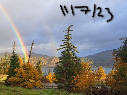
Rain this morning ends quickly and leaves us dry. A little drizzle may return late afternoon. Temps will be in the upper 40’s early and low 50’s later. Moderate westerlies. 95% chance of rainbows. Wednesday will be high overcast (pretty sunrise) and then mostly clear. Temps start in the upper 30’s to low 40’s and climb to the low 50’s. Calm wind. No rainbows. Thursday will be cloudy in the morning and rainy in the afternoon. Temps start in the mid 30’s and rise to the upper 40’s. Light easterlies. 4% chance of rainbows.
Looking for a complete Columbia Gorge forecast? Looking for more humor in your weather? Obscenities? You’re looking for my TATAS: Temira’s Awesome Travel Advisory Service on Facebook.
Local-ish Events
Please let me know of outdoor-related local-ish events. If you don’t tell me, I don’t know!
There’s a Nordic ski swap at Working Hands in Hood River on November 11th, 4-6pm. HRATS has a work party s in Post Canyon on November 12th. The. On November 28th, Amayah’s has their one-year anniversary party in Biggs. Also, every first Thursday, 1pm to 4pm, they are offering free meals to all. Yup. That’s right. Free Amayah’s once a month!
Regular weekly events:. NK Studio’s by-donation Tuesday morning yoga class is back. Ferment’s Tuesday night 4-mile walk/run is at 6pm. There’s meditation with monks at 5:15pm (an hour) and 6:30pm (30 minutes plus a talk) at Yoga Samadhi in White Salmon. The Tri Club is done for the season. At 7:15am on Wednesdays, there’s a run from the White Salmon Bakery. At 7am on Friday morning, there’s a run from Pine Street Bakery. On Fridays at 2:30pm, there’s a free meditation and stretching class at Yoga Samadhi. On Saturday at 9am, there’s a by-donation outdoor group fitness on the 2rd floor deck about Ferment Brewing.
Cycling
Mud. Don’t. You’ll damage the trails. Ride gravel. Ride your trainer. Build trails. There are trail builders seeking extra hands on seven additional miles of trail on Whoopdee. Contact HRATS for more information. See events section of this report for upcoming trail work parties on various trail systems. Don’t ride in the mud, or you’ll do permanent damage. Also, people will have to fix your messes rather than building you new trails. Just don’t, okay?No trails have closed yet due to snow, but we’re likely to lose the highest-elevation trails, at least temporarily, on the 25th . If you’re parking at Post Canyon, you will need a parking pass. Those can be purchased at many local shops or online.
Sprinter Van of the Week!
 Click here for the Sprinter Van map of the world!!!
Have an awesome day!
