

GORGE WIND FORECAST
If you’re still seeing yesterday’s and it’s after 9am, try opening this in an incognito window AND/OR FLUSHING YOUR CACHE or do a do a hard refresh (Ctrl+Shift+R / Cmd+Shift+R)
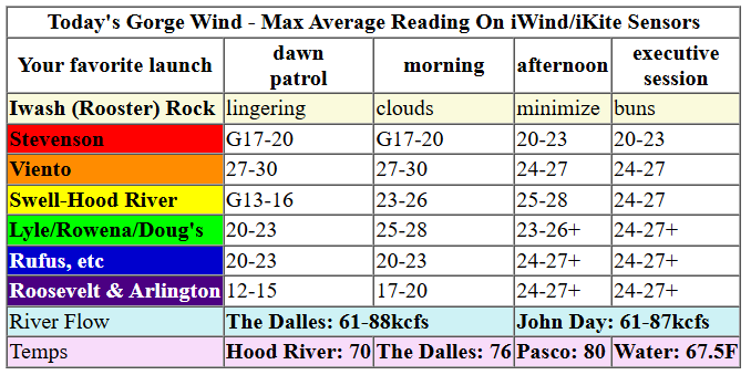
Keep in mind that this forecast attempts to predict what the iKite/iWind sensors will read. Think like a local! All sensors are not equal. Swell reads low. Viento/Arlington/The Wall read high compared to Swell. 30mph at Rufus (The Wall sensor) is about 23-24mph at Swell. 30mph at Swell is about 35-37mph at Rufus/Viento/Arlington. Hope that helps!
SHORT-TERM gorge wind forecast

Hi friends! Guess who finally got back on the water yesterday after six weeks on injured reserve? MEEEEEEEEEEEEEEE! It’ll take some time before I’m back to full capacity, but it sure was nice to see everyone and to reunite with the Nch’i Wana! And what a day it was – once again, marine clouds outperformed the Gorge wind forecasts and gave us more gradients than expected: 0.16 from PDX to DLS at one point! Yay! We’ll have another windy day today, marginal westerly conditions Wednesday and Thursday, and a windy day Friday. Models are hinting at easterlies for the weekend.
Tuesday morning started out windy with pressures of 30.05/29.93/29.87 for gradients of 0.12/0.06. A front is moving through, and another is offshore combining with 1020mb offshore high pressure. TJ and Eddy’s Dawn Patrol had some big readings on the iWind/iKite sensors: 28 in Viento, 26 at Rowena, and 24 at The Wall. Stevenson was 19, the Hatch 12, and Arlington 14. Models suggest some up-and-down to the wind today as the first front clears the area. We also have a cloud problem: the marine layer is past Hood River; we’ll need to wait a bit for it to burn back for Hatch goodness. Do not forget that there is bridge work going on from 7:30-3:00 with short interruptions most of the time and up to one hour delays 9-11am and 1-3pm.
All that said… Morning wind builds to 25-28mph from Viento to Avery with gusty 19-22mph in cloudy Stevenson and 23-26mph at Rufus. Models suggest a dip mid-morning with gusty 23-26mph between Viento and Avery and less at Rufus. The Hatch won’t fully fill in until the clouds are gone from Underwood eastward. Afternoon wind rebuilds to 24-27mph from Stevenson to Arlington. Given that clouds will never burn off fully in the metro area, periods of slightly more wind between Viento and Rufus are possible. River flow over the last 24 hours was 61-88kcfs (with weeds), river temp is 67.5F, and high temp forecast is 70 in Hood River and upper 70s east of The Dalles. I’m sore AF, but I hope to see you out there!

RIVER FLOW FOR SITES BETWEEN AVERY (EAST OF THE DALLES) AND RUFUS: CLICK HERE FOR JOHN DAY DAM FLOW.
RIVER FLOW FOR SITES BETWEEN STEVENSON AND DOUG’S BEACH (WEST OF THE DALLES): CLICK HERE FOR THE DALLES DAM FLOW

LONGER-TERM gorge wind forecast
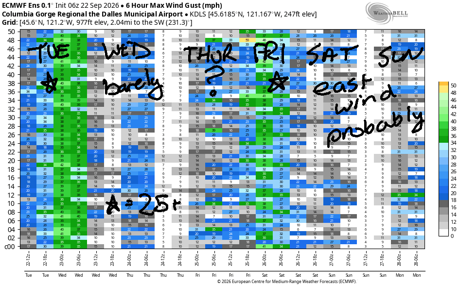
On Wednesday, a weak weather system moves through and results in less wind. Early wind looks like 13-16mph from Viento to the Hatch with 10-13mph east of the Hatch out into the desert. We’ll see a slow and steady build to 17-20mph from Stevenson to Hood River, perhaps to the Rowena stretch. Highs: 74 in Hood River and 78 in The Dalles.
A strong weather system expected sometime Thursday sets us up for an unpredictable day. Wind will be light/variable in the morning in response to a strong offshore low. As that system moves closer and a front/rain approaches, we’ll see a burst of gusty, difficult-to-predict westerlies ahead of the arriving rain. Most indicators have the rain (and thus the wind) arriving late in the day and moving rapidly from west to east. Best guess: gusty 18-23mph for a short period, but it might arrive after dark.
That system moves through Thursday night and is followed by the aforementioned upper low moving inland Friday daytime with moderate offshore high pressure building behind. This is a solid setup that favors The Wall and Arlington. Depending on where the cloud line ends up, we could see solid westerlies all the way from the Hatch to Boardman. For the weekend: probably easterlies of some sort. That’s all for today. See you on the Nch’i Wana soon!
Tip via venmo, cash or check
Want to subscribe to the email version, support Temira, and get the forecast earlier? Click on the blue box up above or use the methods below. Year-round is $29.99 or more if you think it’s worth more. Only need snow or only need wind? Warm season (May-Oct) or cold season (Nov-Apr) is $19.99 or more if you think it’s worth more. Thanks for your support!

JONES BEACH, SAUVIE ISLAND, & COAST FORECAST
Wind northerly unless otherwise indicated. For coast, it’s North/Central/South with the “central” at approximately Florence. Swell forecast from NWS for central coast. Jones: westerly unless otherwise stated. Sauvie Island: northerly unless otherwise stated.
Coast Tuesday: LTNW/LTNW/N25-30, NW swell 6′ @ 12 seconds. And SW 2′ @ 17. Wednesday: 10-15/15/25, NW 6′ @ 11 and SW 2′ @ 16. Thursday: variable to 10/NE15/S15-20, NW 6′ 11 and SW 2′ @ 15. Jones Tuesday: 13-16. Wednesday: 10-13. Thursday: LTE. Sauvie Island Tuesday: 11-14. Wednesday 10-13. Thursday: variable to 10.
BARE BONES HOOD RIVER WEATHER FORECAST
Partly cloudy this morning, mostly clear this afternoon. Temps start near 60 and rise to 70. Strong westerlies. No rainbows. Wednesday will be mostly clear then partly high overcast. Temps start in the mid 40s and rise to the mid 70s. Moderate westerlies. No rainbows. Thursday will be partly to mostly cloudy then rainy and cloudy. Temps start near near 50 and rise to the mid 70s. Light and variable wind early. Moderate westerlies later. 2% chance of rainbows.
BIKE TRAILS INFO
NEXT WORK PARTY: No known upcoming work parties. Lemme know if you hear of one!
CLOSED TRAILS: Anything south of the 44 Road due to the Grasshopper Fire / Forest Closure Order: for example – Boulder Lakes, Gunsight, Gumjuwac, Lookout Mountain, 450, Fifteenmile.
TEMIRA’S AWESOME TRAVEL ADVISORY SERVICE
HYPERLOCAL WEATHER FORECAST FOR THE COLUMBIA GORGE
THE DALLES, HOOD RIVER, WHITE SALMON, TROUT LAKE, STEVENSON, CASCADE LOCKS, PARKDALE, ODELL, HUSUM, BZ, MILL A, WILLARD, GOLDENDALE, RUFUS, ARLINGTON, boardman
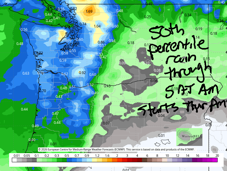
Good morning, neighbors! Who’s ready for rain?!?!!? Pretty much all of us are going to get some on Thursday! Between now and then, you know what to do: pick up some Vaseline so you can spread it all over you to dance naked in the rain when it arrives! PS it’s legal to be naked on both sides of the Nch’i Wana unless you’re doing it for lewd purposes! So many exclamation points this morning!!!
Nothing to exclaim about in Glenwood: it’s 42 degrees, the answer to life, the universe, and everything. On tap today: another windy day. We’ve been doing great work not starting any new fires. Keep it up! After a warm start – 60 in Hood River – we’ll end warm-but-not-hot: 69 (you know what to do!) in Stevenson, 70 in Hood River, 76 in The Dalles, and 80 in Pasco. With temps increasing all the way out to Pasco, we’ll have strong westerlies all the way from Stevenson to Arlington’s Triangle: 25-30mph this afternoon. Low clouds west of Hood River never burn off fully. To the east: high clouds join this afternoon and leave us with a pretty sunset.
Don’t forget about this: work this week on the Hood River Bridge: full overnight closures: Sept. 21, 22, 23 and 24, from midnight to 6 a.m. Daytime work: Sept. 21, 22 and 23, from 7:30 a.m. to 3 p.m. Most daytime traffic interruptions will last approximately 15 minutes. Longer interruptions of up to approximately one hour may occur from 9 to 11 a.m. and 1 to 3 p.m.
Things calm down on Wednesday. They calm down enough that morning temps will drop to the low to upper 40s many places. Most of us start the day with a few high clouds and a colorful sunrise. That’s also how we finish the day, minus the sunrise. Sunset replaces sunrise at the end of the day. Wind will be around 15mph most of the day between Stevenson and Hood River, potentially rising to 20mph in the afternoon. East of Hood River, the wind gets lighter and lighter until it stops being windy east of The Dalles. Highs: 72/74/78/77.
Thursday’s yay exciting! More exclamation points! An upper level low offshore sends rain our way. As of this morning, NWS was suggesting the rain would start late morning or early afternoon, but the GFS deterministic holds it off until the evening, and the Euro deterministic holds off the rain until after TATAS goes to bed (MAKE BEDTIME EIGHT AGAIN). Either way, it’s going to rain, and it’s going to rain hard enough to cause hydroplaning and other unpleasant driving experiences in various locations to be named later, but definitely west of Hood River. Morning temps: 50ish. Afternoon: 75-79, assuming the rain waits to arrive until evening. Wind will be light/variable early and will pick up hard, fast, and short-lived ahead of the rain.
Friday brings morning showers and afternoon flowers. Flowers because we’ll be rehearsing for my friend’s wedding. Showers should be done by 11am. Wind: yes, probably quite a bit of it. High temps: 62-72, hottest in Pasco. Saturday: cool, breezy, and a nice day for a wedding! That’s all for now. Safe travels. -TATAS
HEY! DON’T STOP READING! Is this community-focused forecast helpful to you? It sure is! It takes me a couple hours a day to write. Please join your friends and neighbors in contributing to keep it going. Venmo: @thegorgeismygym PayPal: twomirrors@gmail.com USPS: Temira / PO Box 841 / Hood River, Oregon 97031
MT HOOD SNOW FORECAST

QR codes and links for end-of-season tips – thank you!!!
Cash/check: Temira – PO BOX 841 – Hood River, Oregon 97031