

GORGE WIND FORECAST
If you’re still seeing yesterday’s and it’s after 9am, try opening this in an incognito window AND/OR FLUSHING YOUR CACHE or do a do a hard refresh (Ctrl+Shift+R / Cmd+Shift+R)
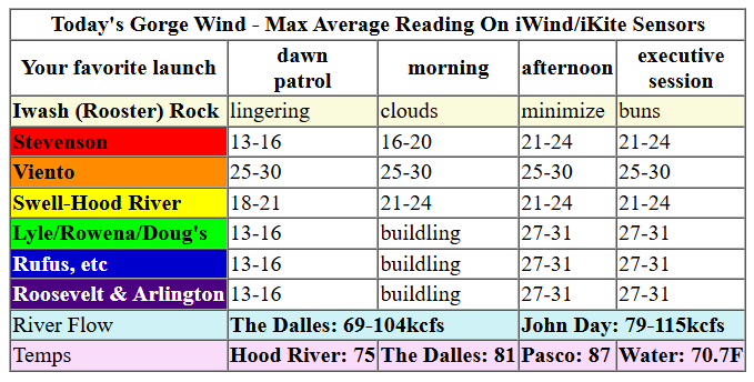
Keep in mind that this forecast attempts to predict what the iKite/iWind sensors will read. Think like a local! All sensors are not equal. Swell reads low. Viento/Arlington/The Wall read high compared to Swell. 30mph at Rufus (The Wall sensor) is about 23-24mph at Swell. 30mph at Swell is about 35-37mph at Rufus/Viento/Arlington. Hope that helps!
SHORT-TERM gorge wind forecast

Hi friends! Autumn is making an early showing, and with it comes lackluster wind. Even so, there may be some short periods of just-enough to get some of you out there foiling. Next chance for a more reliable, stronger day in the Gorge wind forecast looks like next Monday… maybe I’ll be healed enough to take a lap or two then!
Looking at Thursday… conditions started light and variable which makes the folks fishing happy! Our setup for today includes a low pressure system offshore and another moving inland along with a cold front exiting the area to the east. Atmospheric instability will be present too.
Best chance today: after 2pm between Avery and Rufus when we could see gusty 17-20mph for a few hours. Surface-based thunderstorms may pop up today. If you see thunderheads building, get off the river! Lightning is bad for your health! River flow over the last 24 hours was 69-97kcfs, river temp is 70.0F, and high temp forecast is 64F in Hood River and 70F out in the desert.

RIVER FLOW FOR SITES BETWEEN AVERY (EAST OF THE DALLES) AND RUFUS: CLICK HERE FOR JOHN DAY DAM FLOW.
RIVER FLOW FOR SITES BETWEEN STEVENSON AND DOUG’S BEACH (WEST OF THE DALLES): CLICK HERE FOR THE DALLES DAM FLOW

LONGER-TERM gorge wind forecast
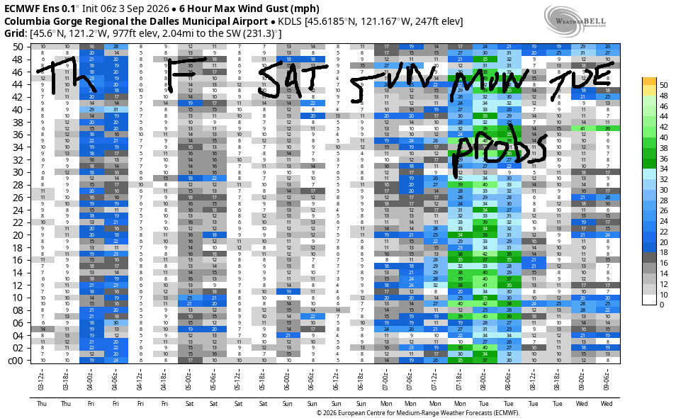
A low pressure system lingers off the coast most of Friday and moves inland late in the day. This gives us calm, or nearly-calm, conditions most of the day. After 2pm, or perhaps after 5pm, the low moves inland. At this point, we might get lucky and see gusty 16-19mph between Stevenson and Avery. Once again, afternoon instability may trigger thunderstorms. If that’s the case, the wind may be uncooperative. High temp: 67 in Hood River and low 70s in the desert.
Saturday brings calm conditions until late afternoon or early evening. Models hint at 11-14mph or so from Stevenson to Rowena late afternoon with a touch more possible early evening. High temps: 71-75 degrees with another round of thunderstorms possible in the afternoon.
Some members of the Euro ensemble call for westerlies at 17-20mph on Sunday, and the GFS deterministic likes that idea too. For now, Sunday is a “maybe”. Better chances for stronger westerlies exist on Monday, when a better overall setup is likely to develop. That said, there’s a huge range in the possible outcomes. For now, let’s say 20mph is likely and refine it as we get closer. Wishing you lots of fun with alternative activities this week! See you on the Nch’i Wana one of these days!
Tip via venmo, cash or check
Want to subscribe to the email version, support Temira, and get the forecast earlier? Click on the blue box up above or use the methods below. Year-round is $29.99 or more if you think it’s worth more. Only need snow or only need wind? Warm season (May-Oct) or cold season (Nov-Apr) is $19.99 or more if you think it’s worth more. Same for the cold season forecast. Thanks for your support!

JONES BEACH, SAUVIE ISLAND, & COAST FORECAST
Wind northerly unless otherwise indicated. For coast, it’s North/Central/South with the “central” at approximately Florence. Swell forecast from NWS for central coast. Jones: westerly unless otherwise stated. Sauvie Island: northerly unless otherwise stated.
Coast Thursday: S20-25/S20-25/S20-25, W swell 10′ at 11 seconds and SW 2′ @ 18. Friday: N10-15/LTV/S10, W 6′ @ 10 and SW 3′ @ 18. Saturday: LTN/N10-15/N10-15, N 2′ @ 4 and NW 5′ @ 9. Jones Thursday: LTV. Friday: LTV. Saturday: LTW. Sauvie Island Thursday: S15. Friday: LTV. Saturday: N15-18.
BARE BONES HOOD RIVER WEATHER FORECAST
Cloudy this morning and showery this afternoon with a chance of thunderstorms and/or hail. Temps start near 50 and rise to the mid 60s. Calm wind early. Light westerlies later. 93% chance of rainbows. Friday will be mostly cloudy with showers then partly cloudy with showers and thunderstorms. Temps start in the upper 40s and rise to the upper 60s. Calm wind early. Moderate westerlies later. 96% chance of rainbows. Saturday will be cloudy then partly cloudy. Temps start in the upper 40s and rise to the low 70s. Light westerlies. 71% chance of rainbows.
BIKE TRAILS INFO
NEXT WORK PARTY: September 5th work party in Post has been cancelled due to fire danger.
CLOSED TRAILS: Anything north of the 44 Road due to the Grasshopper Fire / Forest Closure Order: for example – Boulder Lakes, Gunsight, Gumjuwac, Lookout Mountain, 450, Fifteenmile. ALL GREEN MOUNTAIN LANDS: Underwood Mountain, Whoopdee Trail. Kreps Lands, aka Hospital Hill. All gates are closed in Post due to fire danger.
TEMIRA’S AWESOME TRAVEL ADVISORY SERVICE
HYPERLOCAL WEATHER FORECAST FOR THE COLUMBIA GORGE
THE DALLES, HOOD RIVER, WHITE SALMON, TROUT LAKE, STEVENSON, CASCADE LOCKS, PARKDALE, ODELL, HUSUM, BZ, MILL A, WILLARD, GOLDENDALE, RUFUS, ARLINGTON, boardman
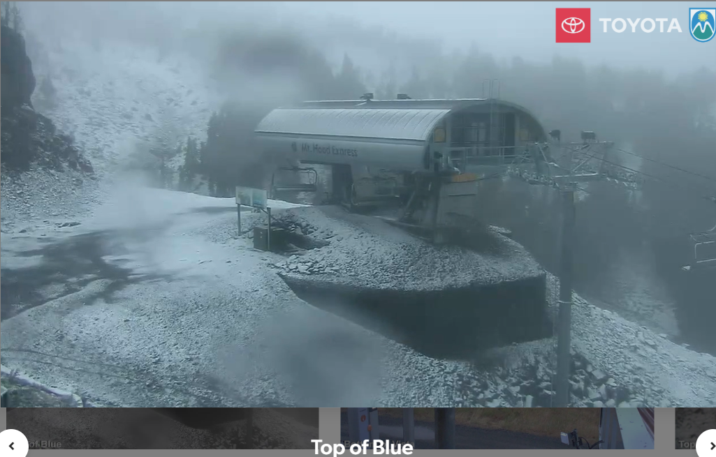
Good morning, neighbors! It’s cool and showery out there this morning for many of us, and this un-summery weather will persist for several days. Just how cool is it? Normal for this time of year is right around 80 degrees in the lowlands, and The Dalles won’t see that warmth until the middle of next week! It’s so cold today that it’s snowing at 6500′, and it’s so cold that the Nch’i Wana has lost two degrees of warmth in the last week or so. Yay for the salmon!
Speaking of salmon, 19,015 adults made it past Bonneville Dam yesterday, and there are a LOT of you out fishing this morning. Fishing conditions will be good (cloudy, showery, not very windy) for much of the next 72 hours. Get on it! Other interesting news this morning: Glenwood started the day warm, 47 degrees, but the top of Mt. Hood Express lift at Meadows was cold: 31 degrees and snowing! For the next couple of days, the snow level hovers around 7000′. Not much moisture will fall, but still… Speaking of moisture… since yesterday, Stevenson area picked up 0.5” of rain, Hood River 0.25”, The ?Dalles 0.15”, and the Goldendale area 0.3”. That’s a solid rain (but not record-setting) for early September. It’s definitely enough to inspire enough curiosity in some chanterelles for them to break the surface of the duff!
Weather for Thursday will be mostly cloudy in the morning to the west and mostly cloudy all day to the east. Afternoon sunbreaks west of The Dalles contribute to instability and potentially fire off some pop-up thunderstorms. Downpours and small hail are possible. Highs today: 62 in Stevenson, 64 in Hood River, 70 in The Dalles, and 72 in Pasco. Wind will; be light and variable this morning with westerlies at 15-20mph possible this afternoon between The Dalles and Rufus.
Friday brings a mostly cloudy, 45-55 degree, calm-wind start to the west side with a mostly clear start east of the Cascade crest. Afternoon: thunderstorms could pop up anywhere in the region. Temps rise to 66-73 degrees, and west wind builds to 15mph between Stevenson and Avery with light wind to the east. Saturday looks nearly identical other than high temps which will be 2-5 degrees warmer.
A weak weather system on Sunday may bring some rain to areas west of Mosier. To the east: sunny. Highs range from 71-78 degrees, warmest in Pasco. West wind builds to 15-20mph in the afternoon. On Labor Day, you should join your union! You should advocate for workers’ rights! You should advocate for a living-wage minimum wage! The weather will be good for all that: partly cloudy, highs in the mid 70s, and breezy. Let’s leave it there for now. Safe travels. -TATAS
HEY! DON’T STOP READING! Is this community-focused forecast helpful to you? It sure is! It takes me a couple hours a day to write. Please join your friends and neighbors in contributing to keep it going. Venmo: @thegorgeismygym PayPal: twomirrors@gmail.com USPS: Temira / PO Box 841 / Hood River, Oregon 97031
MT HOOD SNOW FORECAST

QR codes and links for end-of-season tips – thank you!!!
Cash/check: Temira – PO BOX 841 – Hood River, Oregon 97031