

GORGE WIND FORECAST
If you’re still seeing yesterday’s and it’s after 9am, try opening this in an incognito window AND/OR FLUSHING YOUR CACHE or do a do a hard refresh (Ctrl+Shift+R / Cmd+Shift+R)

Keep in mind that this forecast attempts to predict what the iKite/iWind sensors will read. Think like a local! All sensors are not equal. Swell reads low. Viento/Arlington/The Wall read high compared to Swell. 30mph at Rufus (The Wall sensor) is about 23-24mph at Swell. 30mph at Swell is about 35-37mph at Rufus/Viento/Arlington. Hope that helps!
SHORT-TERM gorge wind forecast

Hi friends! Reality beat the Gorge wind forecast models again yesterday – the Hatch held on to 17-20mph from mid-morning on, which was exactly the opposite of what the models said it would do. Why? I’m guessing clouds lingered longer than expected in the metro area, once again. Today (Sunday) brings lighter wind. Stronger westerlies return on Monday and Tuesday with a lighter, but still decent day probable on Wednesday. Thursday’s almost certainly going to be lighter, but we may have a stronger (and gusty) day on Friday after a weather system move through.
Looking at Sunday’s start… we have clear sky all the way from the metro area to Hood River with pressures of 30.07/30.05/30.05. Wind was light and variable to start the day most places. Models give us a short period of 13-16mph westerlies from Viento to the Hatch this morning before the wind dies off this afternoon and drops below 10mph.
It’s possible we could see the 13-16mph wind hold on all day – models do call for 7 degrees of temp difference between the metro area and The Dalles… If it does linger, Stevenson will also be breezy. River flow over the last 24 hours was 60-78kcfs, river temp is 67.5F, and high temp forecast is 85 in Hood River.

RIVER FLOW FOR SITES BETWEEN AVERY (EAST OF THE DALLES) AND RUFUS: CLICK HERE FOR JOHN DAY DAM FLOW.
RIVER FLOW FOR SITES BETWEEN STEVENSON AND DOUG’S BEACH (WEST OF THE DALLES): CLICK HERE FOR THE DALLES DAM FLOW

LONGER-TERM gorge wind forecast
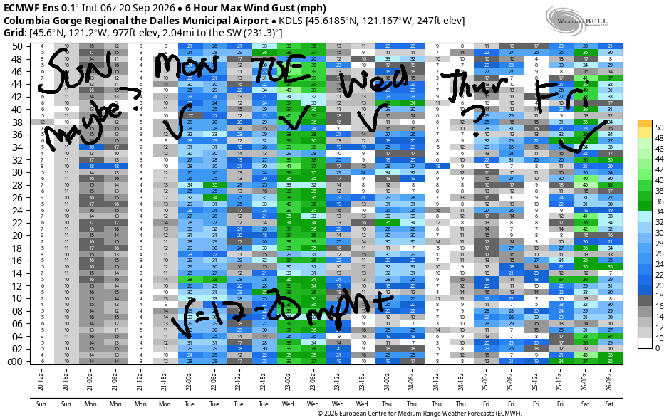
Monday sees the hottest temps return to the desert as a weak wave offshore helps cool off the west side. Early wind will be 20-23mph from Viento to the Hatch with 17-20mph from Hood River to Mosier. Westerlies build to 24-27mph from Stevenson to Mosier late morning with 21-24mph from Rowena to Avery. Models say Rufus will join at 22-25mph mid afternoon. Solid day, eh? High temps: 82 in Hood River and 87 in the desert.
Tuesday brings another solid day, but a weather system approaching from the west will reduce wind quality. Dawn Patrol could be as strong as 25-28mph from Viento to Hood River and perhaps Mosier with 13-16mph east of Mosier all the way to Arlington. Wind quickly drops to 22-25mph by 8am. We should see 22-25mph hold from Stevenson to Avery and fill in at Rufus. That’s the GFS forecast. The Euro is more optimistic and is calling fro 25-28mph readings from Avery to Rufus. There’s a good chance we’ll be revising the Tuesday forecast between now and then! High temps: 74 in Hood River and 80 in the desert.
Models disagree on the forecast for Wednesday. GFS: not windy at all. Euro: potentially 17-20mph late in the day. On Thursday, we should see teens or better, but the overall weather picture isn’t set. A wet system is possible overnight Thursday, which would leave us post-frontal and windy on Friday. Models are hinting at a mid-20s desert day Friday. Given all the moving parts and uncertainty, I’ll leave it there for now. Have a great day today!
Tip via venmo, cash or check
Want to subscribe to the email version, support Temira, and get the forecast earlier? Click on the blue box up above or use the methods below. Year-round is $29.99 or more if you think it’s worth more. Only need snow or only need wind? Warm season (May-Oct) or cold season (Nov-Apr) is $19.99 or more if you think it’s worth more. Same for the cold season forecast. Thanks for your support!

JONES BEACH, SAUVIE ISLAND, & COAST FORECAST
Wind northerly unless otherwise indicated. For coast, it’s North/Central/South with the “central” at approximately Florence. Swell forecast from NWS for central coast. Jones: westerly unless otherwise stated. Sauvie Island: northerly unless otherwise stated.
Coast Sunday: 20/20/25-30, N swell 4′ at 6 seconds and SW 2′ @ 17. Monday: 5-10/15/25-30, NW 5′ @ 9 and SW 2′ @ 18. Tuesday: LTNW/NW10-15/N25-30, NW swell 7′ @ 10 seconds and SW 2′ @ 17. Jones Sunday: 15-18. Monday: 11-14. Tuesday: 12-15. Sauvie Island Sunday: 14-17. Monday: 11-14. Tuesday: 10-13.
BARE BONES HOOD RIVER WEATHER FORECAST
A few Nothing this morning then clear. Temps start near 50 and rise to the mid 80s. Moderate westerlies. No rainbows. Monday will be partly high cloudy then overcast. Temps start in the mid 50s and rise to the low 80s. Moderately strong to strong westerlies. No rainbows. Tuesday will be cloudy then sunny. Temps start in the low 50s and rise to the mid 70s. Moderately strong to strong westerlies. No rainbows. Next chance of rain is late Thursday into Friday.
BIKE TRAILS INFO
NEXT WORK PARTY: No known upcoming work parties. Lemme know if you hear of one!
CLOSED TRAILS: Anything south of the 44 Road due to the Grasshopper Fire / Forest Closure Order: for example – Boulder Lakes, Gunsight, Gumjuwac, Lookout Mountain, 450, Fifteenmile.
TEMIRA’S AWESOME TRAVEL ADVISORY SERVICE
HYPERLOCAL WEATHER FORECAST FOR THE COLUMBIA GORGE
THE DALLES, HOOD RIVER, WHITE SALMON, TROUT LAKE, STEVENSON, CASCADE LOCKS, PARKDALE, ODELL, HUSUM, BZ, MILL A, WILLARD, GOLDENDALE, RUFUS, ARLINGTON, boardman

Good morning, neighbors! Peak heat happens today, tomorrow (Monday) looks warm, and then we slide into cooler weather through the extended forecast period. We might even get some rain late Thursday into Friday!
But not today! Today’s gonna be sunny and warm*. *Those of you west of Wyeth might have a few clouds to start, but they’ll burn off. Afternoon temps rise to 85 in Stevenson, Hood River, and Pasco with 88 in The Dalles. This sets us up for light to moderate westerlies, 10-15mph, from Stevenson to The Dalles this afternoon. That is all for Sunday.
Before we continue with the weather around here, let’s take a look at the rest of the country. As you see from the SPC thunderstorm map, we have a good portion of the country being penetrated by a Level 1 (dark green) risk for severe thunderstorms. Those folks are saying, “Well, fuck!” Some areas of Oklahoma and Kansas and Nebraska are all loaded up to shoot a load of Level 2. “Balls!” they are saying, “Balls!” Well, in this case, it’s just one ball. Do be safe if you’re under those yellow zones today!
On Monday, an offshore weather system impacts us (a little). Result: strong wind and increasing afternoon clouds. Morning will be cloudy west of Stevenson with mostly clear sky to the east. Temps: 50-60. Highs make it to 79 in Stevenson, 82 in Hood River, 87 in The Dalles (hot!) and 86 in Pasco (also too hot for TATAS!). West wind will be 20-25mph between Viento and Mosier early in the morning. It builds to 25mph from Stevenson to Rufus in the afternoon. This probably isn’t quite enough to send your rubbish bins eastward, but do keep a close eye on them. They’re like indoor cats – always looking for an opportunity to expand their range!
High temps drop about 8 degrees on Tuesday. It won’t be jacket weather, but it’ll be noticeably cooler. Low clouds make it all the way to Hood River in the morning. To the east: a few high clouds. Temps will be 50-60 to start the day. Afternoon highs: 72/74/79/82. West wind will be 25mph in the morning between Viento and Mosier with 15-20mph east to Arlington. Afternoon: 25mph all the way from Stevenson to Rufus.
Wednesday and Thursday looks cooler, 71-77, and breezy (15-20mph, probably). Late in the day Thursday, we may see some rain. About 80% of the members of the Euro Ensemble are on board with rain overnight Thursday into Friday with sprinkles continuing into Friday. Weekend weather: cooler and probably dry. That’s all I have to say for today. Safe travels. -TATAS☺
HEY! DON’T STOP READING! Is this community-focused forecast helpful to you? It sure is! It takes me a couple hours a day to write. Please join your friends and neighbors in contributing to keep it going. Venmo: @thegorgeismygym PayPal: twomirrors@gmail.com USPS: Temira / PO Box 841 / Hood River, Oregon 97031
MT HOOD SNOW FORECAST

QR codes and links for end-of-season tips – thank you!!!
Cash/check: Temira – PO BOX 841 – Hood River, Oregon 97031