

GORGE WIND FORECAST
If you’re still seeing yesterday’s and it’s after 9am, try opening this in an incognito window AND/OR FLUSHING YOUR CACHE or do a do a hard refresh (Ctrl+Shift+R / Cmd+Shift+R)
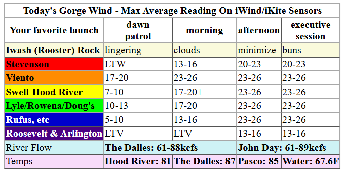
Keep in mind that this forecast attempts to predict what the iKite/iWind sensors will read. Think like a local! All sensors are not equal. Swell reads low. Viento/Arlington/The Wall read high compared to Swell. 30mph at Rufus (The Wall sensor) is about 23-24mph at Swell. 30mph at Swell is about 35-37mph at Rufus/Viento/Arlington. Hope that helps!
SHORT-TERM gorge wind forecast

Hi friends! We’ll have a couple windy days to start this week. That’s followed by a rest day on Wednesday. On Thursday, a wet weather system is forecast in the second half of the day. We may be blessed with some unreliable, gusty westerlies ahead of the system. Or maybe not. There’s a decent chance of westerlies on Friday after that Thursday system exits the area and high pressure rebuilds offshore. As we move into next weekend, westerlies may be replaced by easterlies, but there’s quite a bit of uncertainty present.
Monday morning started off with pressures of 30.02/29.95/29.95 for gradients of 0.07/0.00. Viento was reading 20mph early in the day, and all other locations were light/variable. Solid marine clouds blanketed the west side, and clear sky was present to the east. All-in-all, it’s a good setup, although an approaching dry weather system may impact the afternoon wind quality.
By late morning, westerlies build to 23-26mph between Viento and the Hatch with 18-21mph from Hood River to Mosier. Stevenson joins in as well after clouds burn back. Westerlies should hold at 23-26mph into the afternoon and fill in as far east as Doug’s. Between Avery and Rufus, the wind rises to 20-23mph early afternoon and 23-26mph mid to late afternoon. As high clouds move in this afternoon, we may see the wind drop off between Swell and Hood River and become gustier in other locations. River flow over the last 24 hours was 61-89kcfs, river temp is 67.6F, and high temp forecast is 81F in hood River and 87F in the desert.

RIVER FLOW FOR SITES BETWEEN AVERY (EAST OF THE DALLES) AND RUFUS: CLICK HERE FOR JOHN DAY DAM FLOW.
RIVER FLOW FOR SITES BETWEEN STEVENSON AND DOUG’S BEACH (WEST OF THE DALLES): CLICK HERE FOR THE DALLES DAM FLOW

LONGER-TERM gorge wind forecast
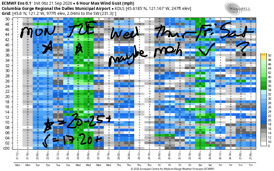
Tuesday starts with solid westerlies thanks to solid low clouds on the west side. Models suggest 23-26mph from Viento to Mosier right off the bat. My fingers are crossed – sometimes we have to wait for the morning wind this time of year due to the colder nights. Models suggest 23-26mph most of the morning with the wind filling in from Stevenson to Avery by late morning. As a weather system moves closer in the afternoon, the Stevenson-Hood River zone falls to gusty 18-21mph, and Mosier to Rufus build to gusty 24-27mph. High temps: 73 in Hood River and upper 70s in the desert.
Wednesday looks lighter as 1) a weak weather system moves through and 2) we lose the support of the offshore high pressure and 3) cross-Cascade temp gradients fall. As of this morning, the Gorge wind forecast for Wednesday is 11-14mph.
A stronger weather system is forecast on Thursday with rain in the afternoon. It’s possible we’ll see gusty 20mph or so ahead of the incoming rain, but this is far from an ideal setup. Chances are decent we’ll see 17-20mph+ at some point, somewhere, but it probably won’t be long-lived, and it definitely won’t be steady! Highs: 73-77.
Sometime between Thursday night and Friday morning, the strongest wind field will move through the Gorge. We’ll be left with post-frontal westerlies of some sort Friday. They’ll back off and (probably) shift from east to west as the day progresses. It’s likely we’ll see 17-20mph or more. Uncertainty is present for the weekend, but a significant portion of the models hint at easterlies. We’ll have to wait and see how things play out as we get closer. Have fun out there today. Get some for me – I’m still on IR and will be hitting up the pool! Again!
Tip via venmo, cash or check
Want to subscribe to the email version, support Temira, and get the forecast earlier? Click on the blue box up above or use the methods below. Year-round is $29.99 or more if you think it’s worth more. Only need snow or only need wind? Warm season (May-Oct) or cold season (Nov-Apr) is $19.99 or more if you think it’s worth more. Thanks for your support!

JONES BEACH, SAUVIE ISLAND, & COAST FORECAST
Wind northerly unless otherwise indicated. For coast, it’s North/Central/South with the “central” at approximately Florence. Swell forecast from NWS for central coast. Jones: westerly unless otherwise stated. Sauvie Island: northerly unless otherwise stated.
Coast Monday: LTNW/NNW10/N25-30, W swell 5′ @ 12 seconds and SW 2′ @ 18. Tuesday: LTNW/NW10-15/N25-30, NW swell 6′ @ 12 seconds and SW 2′ @ 17. Wednesday: LTNW/N10-15/N25, N 6′ @ 11 and SW 2′ @ 16. Jones Monday: 13-16. Tuesday: 13-16. Wednesday: 7-10. Sauvie Island Monday: 11-14. Tuesday: 11-14 > 5pm. Wednesday: 10-13.
BARE BONES HOOD RIVER WEATHER FORECAST
Clear this morning with increasing high clouds today. Temps start in the mid 50s and rise to the low 80s. Moderately strong to strong westerlies. No rainbows. Tuesday will be cloudy then mostly clear. Temps start in the low 50s and rise to the low 70s. Moderately strong to strong westerlies. No rainbows. Wednesday will be partly cloudy. Temps start in the upper 40s and rise to the mid 70s. Light westerlies. No rainbows.
BIKE TRAILS INFO
NEXT WORK PARTY: No known upcoming work parties. Lemme know if you hear of one!
CLOSED TRAILS: Anything south of the 44 Road due to the Grasshopper Fire / Forest Closure Order: for example – Boulder Lakes, Gunsight, Gumjuwac, Lookout Mountain, 450, Fifteenmile.
TEMIRA’S AWESOME TRAVEL ADVISORY SERVICE
HYPERLOCAL WEATHER FORECAST FOR THE COLUMBIA GORGE
THE DALLES, HOOD RIVER, WHITE SALMON, TROUT LAKE, STEVENSON, CASCADE LOCKS, PARKDALE, ODELL, HUSUM, BZ, MILL A, WILLARD, GOLDENDALE, RUFUS, ARLINGTON, boardman
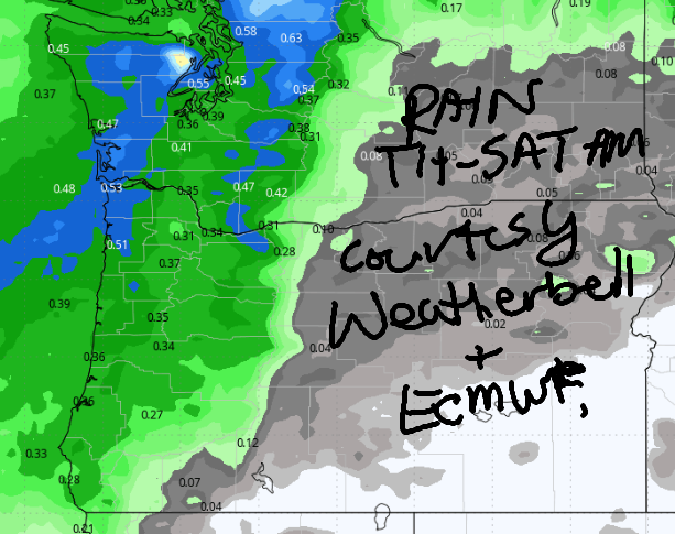
Good morning, neighbors! Last hot day for a while – high temps bounce up and down this week but generally trend downward into Saturday. Rain is likely (not certain) Thursday afternoon into early Friday morning. After that – dry and cooler with a chance of frost Saturday and/or Sunday morning for our coldest spots. More on that a few paragraphs down…
No frost anywhere this morning! Glenwood was 41 degrees to start the day with the rest of us 45-60. A few spots along the Nch’i Wana and in areas above the inversion were 60+ to start Monday. I felt 60+ when I climbed out of bed – still not recommending the herniated disc! Zero stars! Do not recommend!
For the rest of Monday… we’ll have continued erosion of democratic norms (who will be banned from the press corps today? Maybe TATAS!) and increasing high clouds. Temps ignore the clouds and max out at 81 in Hood River, and 87 from The Dalles eastward. West wind builds to 20-25mph from Stevenson to Rufus and holds into the evening. Boardheads: happy. People fishing: not happy. Also on the table today: intermittent work on the Decrepit Old Bridge Of Hood River between 7am and 3:30pm. Expect delays.
Low clouds push inland to Hood River overnight into Tuesday morning while areas to the east will be mostly clear. Morning temps: 50-60. Hopefully I’ll feel 50 instead of 60 tomorrow when I wake up! A few low clouds linger west of Hood River in the afternoon, and everyone else stays sunny. Wind: windy! 25mph between Viento and Mosier early with 15mph east of Mosier to Arlington’s Circle (you thought I was gonna say triangle!). Afternoon wind: 25mph from Stevenson to Rufus with 15-20mph east of Rufus to Arlington’s Square. Highs range from 73 in Hood River to 77 in The Dalles and 80 in Pasco.
Lighter wind and lesser clouds on Wednesday morning give us a cooler start: 40-55 degrees. We’ll have a few clouds at varying heights during the day – Mother Nature doesn’t want you to get bored! Expect light wind: 10-15mph west of The Dalles and less to the east. Highs: mid 70s to the west and east of The Dalles (aka: the oven), where it’ll be pushing 80. Speaking of ovens – a few years ago it reached 118 in The Dalles. I baked cookies on my dashboard. They were delicious. I hope it never gets that hot again, but climate change trends suggest it will!
Thursday looks cooler and potentially rainy. Timing: uncertain. Rain quantity: uncertain. Let’s call it about a 70% chance of rain all the way into the desert. Highs: low to mid 70s. Friday looks much cooler with temps maxing out around 70. Snow level: 5000 feet! A few lingering showers are possible west of The Dalles with snow flurries on the volcanoes.
Things get more interesting on Saturday morning when we may have partly cloudy sky and light easterly wind. It’s likely Glenwood will drop below 36 degrees in this scenario, and the Parkdale area (and perhaps Steel Road area in The Dalles) and Trout Lake could also drop below 36. Ditto on Sunday morning: clear sky, light wind, 850mb temps around +5C. We’ll watch this closely as the weekend approaches. Until then… I’m off to a meditation group. Safe travels. -TATAS
HEY! DON’T STOP READING! Is this community-focused forecast helpful to you? It sure is! It takes me a couple hours a day to write. Please join your friends and neighbors in contributing to keep it going. Venmo: @thegorgeismygym PayPal: twomirrors@gmail.com USPS: Temira / PO Box 841 / Hood River, Oregon 97031
MT HOOD SNOW FORECAST

QR codes and links for end-of-season tips – thank you!!!
Cash/check: Temira – PO BOX 841 – Hood River, Oregon 97031