Meet Temira, your Gorge and Mt. Hood Forecaster

For almost 30 years, Temira (they/them) has been making the most of what the Gorge has to offer: riding river swell on a foil or windsurf board, carving fresh lines through the snow, and cycling all the gravel and pavement and trails. This is Temira’s playground, their gym… their life’s work.
That’s why in 2006, Temira took it upon themselves to create the most accurate, hyper-local weather forecasts possible. Inaccurate predictions had left too many fellow adventurers caught off-guard and in harm’s way. Temira was determined to change that. Today, Temira’s forecasts have become an essential resource for thousands of skiers, snowboarders, wind sports enthusiasts and travelers through the Gorge. With their guidance, you can plan ahead, time your sessions perfectly, and stay safer on the water, snow, and trails.
But the story doesn’t end there. Temira also authors the TATAS Facebook page – the Gorge’s premier source for microclimate forecasts. When winter storms, extreme heat, or other hazardous conditions (avalanches on SR-14 and I-84, for example!) threaten, this community lifeline becomes a vital resource for locals and visitors alike, helping to keep everyone safe.
All of this crucial work – from your personal wind and snow reports to the invaluable TATAS updates – is made possible by Temira’s relentless efforts. But maintaining this labor of love isn’t easy. Each daily forecast can take hours to research and analyze. The website, forecast model subscriptions, and back-end admin work take time and money. That’s where you come in.
By becoming a contributing member, you’re not just supporting Temira’s passion project – you’re investing in the safety and well-being of the entire Gorge community. Your financial support ensures these essential forecasts remain accessible to all, free of charge.
So please, take a moment to click one of the buttons below. Whether it’s a monthly subscription or a one-time donation, every contribution makes a real difference. Help Temira keep this labor of love alive, so we can all continue playing, commuting, and living in the Gorge with peace of mind and the best weather forecasts possible. Thank you!


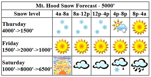
Mt. Hood Snow Forecast
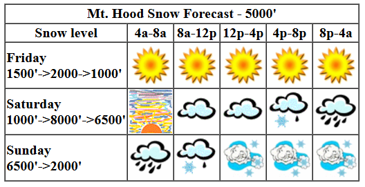
Hi skiers and snowboarders! Meadows and Timberline are open for you to ride today. Yay! Get it while you can. The forecast for next week has done a 180. We were expecting warm, dry, sunny weather. No longer. Now we’re staring down the barrel of a potential atmospheric river, aka the Pineapple Express. The intended route of this freight train isn’t set yet; I’ll talk more about this in a bit. Meanwhile, closer to now, we have clearing sky today, cool, cloudy riding on Saturday, rain followed by snow and stormy conditions Sunday, and more snow, probably of the powder variety, for a stellar storm skiing Monday.
Friday kicks off with clear sky up high and clouds down low. Those clouds are bound for elsewhere – we’ll have sun on the slopes today. The free air freezing level will be 2500′ this morning, 2000′ this afternoon, and 1000′ or so tonight. Temps will be in the mid 20s at 5000′. Wind: NW 10-15 this morning, NW 20-30 this afternoon, and WNW 10-15 after midnight.
High clouds Saturday morning set us up, if the timing is right, for one heck of a spectacular mountain sunrise. After that: increasing clouds. Light snow starts in the afternoon. It switches to rain overnight and increases in intensity. The snow level will be 1000′ early, 1500′ in the afternoon, around 8000′ by 10pm, and back down around 6500-7000′ after midnight. About 0.3” water equivalent (WE) is forecast in the transition from snow to rain. Call that 1-3” new. Overnight, around an inch or rain (yuck) is in the cards. Wind: WNW 10-15 early, WSW 15-25 in the afternoon, WSW 35-45 in the evening, and W 45 overnight.
Sunday looks to start with pouring rain. You’ll note that’s a change from yesterday’s forecast – we were expecting the transition earlier which would have resulted in lifts icing prior to opening. Looks like the icing will happen after opening now. Anyway, the snow level will be 7000′ early, 4000′ in the afternoon, and it’ll slowly fall to 1500-2000′ overnight. About 1.5” (yeah, you read that right) WE is forecast in the transition time period between 4am and 1pm. Mostly rain. After it switches to snow, we’re expecting 0.4” WE by 4pm and 0.6” WE overnight. Conservatively, assuming some of that transition moisture doesn’t fall as snow (it likely will), we should pick up 9-12” of increasingly dry powder at 5000′. Add in strong wind for DEEP snow on leeward slopes: W 45 in the morning, W 40 in the afternoon, and W 35 overnight.
Windy (35mph) snowy (5-8”) cold (snow level 1500-2000′ and temps low-mid 20s) weather continues all day Monday. That’s your storm skiing powder day, folks. We then enter that period of rather uncertain weather. Models were 75% in on sunny/dry when I looked yesterday. There were atmospheric river warning signs, but NOTHING like what I saw this morning. Now we’re about 80-90% of the ensembles on the warm/wet bandwagon starting late Tuesday. The tricky part is we’re not sure yet exactly where the fire hose will take aim, and that has big implications for just how much moisture we’ll get and how much of it will be snow before temps warm. We’ll keep a close eye on this one, for sure. Since we don’t know what’s coming, it’s best to get up there and ride. Right now. Have a great day on the slopes!
Go ahead and subscribe to the forecast using the fancy auto-renew option. Don’t like electronic payment? No problem! You can send a check or cash to: Temira / PO Box 841 / Hood River, Oregon, 97031. Thank you so much for supporting the forecast. I’m glad you find it helpful, and I appreciate your kindness in supporting the work I’m doing!
Gorge Wind Forecast

Hi friends! Wow. What a switch in the forecast for the middle of next week. So much for those big, steady east winds. Now we have easterlies that chase giant offshore low pressure systems. Anyway, let’s talk about the next few days of west wind. Friday kicks off with weather as steady as it gets in November. A brief period of calm with offshore high pressure. We’ll see 19-22 from Viento to Mosier mid-morning with a possibility of 21-24 from Mosier to Rufus this afternoon. When the wind picks up in the Near East this afternoon, it likely drops to 15-18 from Viento to Hood River. Stevenson, trapped under clouds, does less well, perhaps gusty 14-17 today. River flow over the last 24 hours was 81-131kcfs, river temp is 53.24F, and high temp forecast is 47F.
Is this feeling helpful? If so, go ahead and make a contribution using Paypal to support it. Send $19.99 or more, and I’ll send the forecast to your inbox for a year.
Saturday looks calm. High temp: 47F and cloudy. A very rainy day on Sunday, especially in the west, doesn’t stop the wind. Models have backed off on wind strength. We’re probably looking at late morning to early afternoon out east. Call it 24-28 from Avery to Rufus with rain likely east of Rufus. As a matter of fact, there may be rain at Rufus too. You’ll be threading the needle to get this wind. Monday looks like gusty 25-28 from Avery to Boardman. Maybe. Models are less optimistic than they are for Sunday. We’d previously expected a strong inland surface low for the rest of next week. Now: Pineapple Express is more likely. We will see periods of strong east wind as beastly lows move around offshore, but it ain’t going to be sunny and steady like it would have with that inland high. Alas. Details are still shifting around, so we’ll revisit this tomorrow. Have a great day out there!
src=”https://thegorgeismygym.com/wp-content/uploads/2022/07/venmo_200.jpg” alt=”Venmo” />
Jones, Sauvie Island, Oregon Coast: done for the season
Alan’s Sauvie Island Wind Sensor
Very basic Hood River weather forecast. Don’t plan your life around this. You really should read Temira’s Awesome Travel Advisory Service on Facebook
Partly cloudy sky this morning turns mostly clear later. Temps start in the low 40s and rise to the upper 40s. Moderate westerlies. No rainbows. Saturday will be cloudy and frosty to start. Rain arrives late afternoon. Temps will be near 30 early and in the upper 40s alter. Calm wind. No rainbows. Sunday will be rainy. Temps start in the upper 30s and rise to 50 or so. Moderate westerlies. 99% chance of rainbows.
Link to my Local-ish Outdoorsy Events Google Calendar
Please let me know of outdoor-related local-ish events. If you don’t tell me, I don’t know!
Cycling
Please see the HRATS/Hood River County for complete details on Post Canyon closures. Newly reopened in Post: lower Trail 100 paralleling the lower part of Post Canyon Road. The Twin Tunnels Trail between Hood River and Mosier has reopened. Kreps and Green Diamond Lands have reopened. That includes Whoopdee, Hospital Hill, and Underwood. Closed: Gorge 400 and lots of other trails due to the Whisky Creek Fire. Trail near Mt. Adams due to the Williams Mine Fire. Remember that E-bikes are not allowed on USFS non-moto trails. They are allowed on moto trails.
Sprinter Van of the Week!
 Click here for the Sprinter Van map of the world!!!
Have an awesome day!