Meet Temira, your Gorge Forecaster
Temira (they/them) has been exploring and playing in the Gorge since 1997 – starting out as a windsurfer, then expanding into kiting (briefly!), mountain biking, winging, gravel biking, SUP foiling and even extreme gardening! With all that experience, they understand the importance of a reliable forecast. In 2009, frustrated by the lack of accurate forecasts, Temira took matters into their own hands. What began as a daily email chain between friends (Laura Green, Dave Brown, and Temira) quickly grew into a full-blown website and subscription email service.
So, why The Gorge is my Gym? Because I don’t need a traditional gym – and neither do you. The Gorge is our gym! But this blog isn’t just about my adventures; it’s about helping all of you make the most of your limited free time. Whether you’re on the snow, in the river, or on the dirt, this forecast is here to help you have fun.
Each forecast takes time – sometimes up to a couple of hours a day – and maintaining the website costs money. So do the forecast model subscriptions that provide the information underlying this forecast. If you’ve found this service helpful, consider making a contribution or signing up for the (mostly) daily email. Your support helps me keep bringing you the forecasts that make your adventures in the Gorge even better. It also keeps the forecasts free for folks who can’t afford to pay. Community service is important to me. So, pick one of the buttons below – Venmo, PayPal, or even USPS – and make a contribution. Keep this forecast going day after day! Thank you!

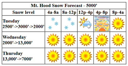
Mt. Hood Snow Forecast
Hi skiers and snowboarders! Three, maybe four days of sunshine and warm weather are planned for the slopes. That’s followed by a transition day Saturday, rain on Sunday, and a return to snowpack-building weather on Monday. There’s some disagreement in the models about temps in the Tuesday-Wednesday time frame – they do agree on lots of precip – but it appears we’ll be back to building the snowpack sometime Thursday.
So let’s look at Wednesday. My latest report is that we have a supportive crust on the snowpack from the last round of warmer weather and precip. This gives us a good shot at corn by the end of the week. Also hopeful: clear sky and quite warm daytime temps. For Wednesday, we’ll have sunshine all day. The free air freezing level rises to 12,000′ or so by the afternoon with temps at 5000′ climbing to the mid 30s. Wind will be light/variable all day with max speed around 10mph.
Thursday will be sunny. The free air freezing level will be around 12,000′ with temps rising to the low 50s. That’s help move the snow towards corn! Wind: light and variable. Friday looks similar: sunny and warm with temps rising to the low 50s and light/variable wind. Sunshine and warm weather (temps in the 40s) continues into Saturday afternoon. High clouds move in during the evening and are followed by drizzle overnight. Drizzly continues into Sunday and turns back to snow (probably a good, solid amount of snow) in the Monday/Tuesday time period. After that, models indicates some rise in temps with a chance of rain. But that’s followed by snow. We’ll keep a close eye on that time period as we get closer. All-in-all, it’s looking like a good chance of an early start to ski season for at least Meadows and Timberline if not for Teacup and Skibowl. Fingers crossed!
Go ahead and subscribe to the forecast using the fancy auto-renew option. Don’t like electronic payment? No problem! You can send a check or cash to: Temira / PO Box 841 / Hood River, Oregon, 97031. Thank you so much for supporting the forecast. I’m glad you find it helpful, and I appreciate your kindness in supporting the work I’m doing!
Gorge Wind Forecast

Hi friends! We’re looking at east wind for the next few days followed by a not-windy weekend. Beyond that, we’ll still have a wind forecast, but you may find your attention drawn to the ski slopes! Let’s look at Wednesday, to start. Pressures were 30.40/30.44/30.44 early in the morning with easterlies around 20mph at Iwash (Rooster) Rock. River flow over the last 24 hours was 81-137kcfs, river temp is probably the same as it was yesterday (my go-to sensor is down this morning), so 57 degrees or so, and high temp forecast is 54F under sunny sky.
Is this feeling helpful? If so, go ahead and make a contribution using Paypal to support it. Send $19.99 or more, and I’ll send the forecast to your inbox for a year.
Thursday will be windier. Expect 35-40 near Iwash (Rooster) in the morning with 25-30 there midday and 20 in the afternoon. Stevenson: 20-25 through early afternoon with 15ish from then on. High temp: 55F under mostly clear sky. Friday starts with easterlies at 25 at Iwash and drops to 10. Stevenson: 15-20mph all day long. High temp: 57F with high clouds. As of today, the weekend looks pretty much calm, as far as wind goes. Enjoy the sun today!

Jones, Sauvie Island, Oregon Coast: done for the season
Alan’s Sauvie Island Wind Sensor
Very basic Hood River weather forecast. Don’t plan your life around this. You really should read Temira’s Awesome Travel Advisory Service on Facebook
Partial Nothing this morning gives way to clear sky. Temps start in the low-mid 30s and rise to the mid 50s. Light easterlies. No rainbows. Thursday starts with Nothing, turns clear, then adds a few high clouds. Temps start in the low 30s and rise to the mid 50s. Light easterlies. No rainbows. Friday will be partly Nothing then partly high overcast. Temps start in the mid 30s and rise to the upper 50s. Light easterlies. No rainbows.
Link to my Local-ish Outdoorsy Events Google Calendar
Please let me know of outdoor-related local-ish events. If you don’t tell me, I don’t know!
Cycling
Please see the HRATS/Hood River County for complete details on Post Canyon closures. Newly reopened in Post: lower Trail 100 paralleling the lower part of Post Canyon Road. The Twin Tunnels Trail between Hood River and Mosier has reopened. Kreps and Green Diamond Lands have reopened. That includes Whoopdee, Hospital Hill, and Underwood. Closed: Gorge 400 and lots of other trails due to the Whisky Creek Fire. Trail near Mt. Adams due to the Williams Mine Fire. Remember that E-bikes are not allowed on USFS non-moto trails. They are allowed on moto trails.
Sprinter Van of the Week!
 Click here for the Sprinter Van map of the world!!!
Have an awesome day!