

GORGE WIND FORECAST
If you’re still seeing yesterday’s and it’s after 9am, try opening this in an incognito window
SHORT-TERM gorge wind forecast
Hi friends! Today we lounge around under blue sky and high pressure with a big “maybe” about whether the wind will get strong enough for light-wind playtime. Tomorrow’s Gorge wind forecast, however, looks much stronger as a trough sends cooler air over the region and the heat low shifts to the desert. Models aren’t sure if it’ll be windy enough on Sunday – for now, let’s say “probably” for some of you. A big, chaotic, potentially rainy day is in the cards for Monday followed by a string of west wind days of varying strength next week.
Let’s look at today, Friday, when chaos is NOT in the cards. Clear sky extends all the way to the coast this morning as high pressure dominates the picture. Thanks to a thermal gradient between the metro area and The Dalles along with offshore high pressure, we’ll see moderate westerlies this afternoon. Enough? Maybe for a few.
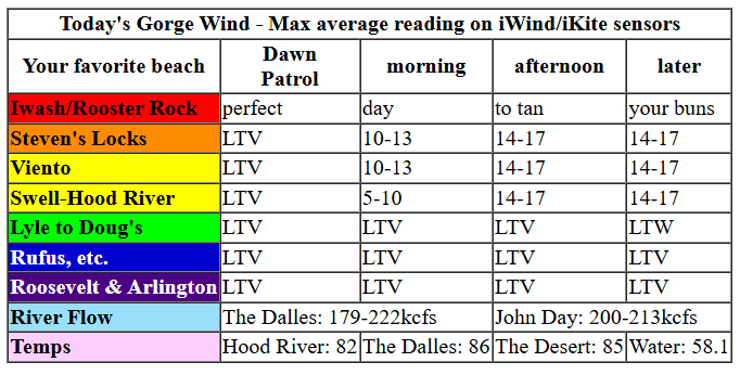
Early pressures were 29.95/29.93/29.93 for light onshore gradients and light/variable wind to start the day. We’ll see a slow build this afternoon to 15-18mph from Stevenson to Doug’s with 11-14mph at Avery and light/variable wind to the east. You’ll find stronger wind at Jones Beach as well as at the central and south coast. River flow over the last 24 hours was 179-222kcfs, river temp is 58.1F, and high temp forecast is 82F with lots of sun.
RIVER FLOW FOR SITES BETWEEN AVERY (EAST OF THE DALLES) AND RUFUS: CLICK HERE FOR JOHN DAY DAM FLOW.
RIVER FLOW FOR SITES BETWEEN STEVENSON AND DOUG’S BEACH (WEST OF THE DALLES): CLICK HERE FOR THE DALLES DAM FLOW

LONGER-TERM gorge wind forecast
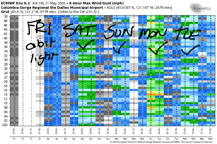
On Saturday morning, we’ll have the heat low in the desert, offshore high pressure, and a trough dropping down from Alaska. Low clouds make it at least as far inland as Viento in the morning. They’re almost certain to burn off in the afternoon, which means the Hatch should be great early but is likely to drop once the metro area clears. Don’t worry – lots of wind is forecast all through the Gorge. TJ and Eddy’s Dawn Patrol should be 23-26+ from Viento to Mosier with 10-13mph at (cloudy) Stevenson and 13-16mph near Rowena. Farther east: 7-10mph to start the day.
Westerlies quickly build to 26-29mph from Viento to Avery with (cloudy) Stevenson slowly building too. Rufus climbs to 17-20mph by midday. In the afternoon, the Hatch is likely to drop while Stevenson hovers at 22-25mph and all other locations from Viento to Rufus rise to 27-31mph or a touch more. Arlington eventually builds to the low-mid 20s. High temp: 79F for Hood River and nearly 90F in the desert.
A mostly-clear start to Sunday combines with dropping offshore pressure for a lesser day. Models do have a fair bit of spread, so take this with a grain of salt. Early wind looks like 12-15mph near Viento and only Viento. We’ll see a slow build to 16-19mph from Stevenson to Rufus by mid-afternoon with 10-13mph at Arlington.
MUCH more interesting weather is forecast for Memorial Day. A cold front sweeps into the PNW with clouds and rain. Ahead of it, a blast of strong westerlies is forecast in the morning and potentially for the rest of the day in the desert. Quite a bit of uncertainty is present, and the wind is likely to be quite gusty, but it will be strong. High temps range from 66F (with rain) in Hood River to 80F (with some showers) in the desert. Lighter wind is likely Tuesday followed by increasing westerlies next week as the desert rebuilds its dominance in the heat game. See you on the Nch’i Wana tomorrow!

Was that helpful? I knew it was! Guess what? All of this crucial work – from your personal wind and snow reports to the invaluable TATAS updates – is made possible by my relentless efforts. Maintaining this labor of love isn’t easy. Each daily forecast takes hours. Website hosting, weather model access, and back-end admin work takes time and money. That’s where you come in.
YOUR CONTRIBUTION MAKES A DIFFERENCE
- SUPPORT ACCURATE, HYPER-LOCAL WEATHER FORECASTING
- ENABLE ACCESS FOR ALL, EVEN THOSE WITH LESS MEANS
- SUPPORT A COOL HUMAN WHO WORKS HARD SO YOU CAN PLAY
Take a moment to click one of the buttons below. Donate $19.99 or more (how much does this forecast enhance your life?) and get the email in your inbox. Whether it’s a renewing subscription (auto-renew) or a one-time donation, every contribution makes a real difference. Help me keep this labor of love alive, so we can all continue playing, commuting, and living in the Gorge with peace of mind and the best weather forecasts possible. Thank you!


Hood River, Oregon 97031


JONES BEACH, SAUVIE ISLAND, & COAST FORECAST
Wind northerly unless otherwise indicated. For coast, it’s North/Central/South with the “central” at approximately Florence. Swell forecast from NWS for central coast. Jones: westerly unless otherwise stated. Sauvie Island: northerly unless otherwise stated.
Coast Friday: 15/15-20/30-35, W swell 2′ @ 10 seconds. Saturday: 15-20/20-25/30-35, W 3′ @ 9. Sunday: LTW/LTV/S10-15, W 6′ @ 14. Jones Friday: 21-24. Saturday: 20-23. Sunday: 7-10.
BARE BONES HOOD RIVER WEATHER FORECAST
Clear sky this morning. A few high clouds later. Temps start in the upper 40s and rise to the lo w80s. Light to moderate westerlies. No rainbows. Saturday will be partly to mostly cloudy then clear. Temps start in the low 50s and rise to the upper 70s. Strong westerlies. No rainbows. Sunday will be partly cloudy then high cloudy. Temps start near 50 and rise to 80. Moderate westerlies. No rainbows. Next chance of rain: Monday.
TEMIRA’S AWESOME TRAVEL ADVISORY SERVICE
HYPERLOCAL WEATHER FORECAST FOR THE COLUMBIA GORGE
THE DALLES, HOOD RIVER, WHITE SALMON, TROUT LAKE, STEVENSON, CASCADE LOCKS, PARKDALE, ODELL, HUSUM, BZ, MILL A, WILLARD, GOLDENDALE, RUFUS, ARLINGTON, boardman
Good morning, neighbors! Another summery spring day is on tap today. Change is in the air for Saturday with a much windier, partly cloudy day on tap. On Monday, dramatic change is forecast – high temps will be down 10-15 degrees, and RAIN is in the cards! Yippee! Looking at Tuesday morning, 850mb temps drop to 0C, and the snow level falls to around 3500′. While temps this low would sometimes bring frost concerns, it appears we’ll be cloudy/showery enough to avoid those kind of troubles this week. I cannot promise anything about your others troubles, but I can say this: carry on with the pepper and tomato and tomatillo planting!
Glenwood and Tehran this morning. Today’s Gorge weather forecast.
Friday started off clear as a bell and calm as a clam under the protection of a gooeyduck. Glenwood was 38F this morning, Tehran was forecast to reach 79F, and my cat was curled up on her elevated trashbin-score foam bed. We’ll pick up a few high clouds this afternoon as temps rise to 79F (Stevenson), 82F (Hood River), and the mid 80s from The Dalles eastward. Wind will be light this morning. It picks up to west 15mph this afternoon between Stevenson and Hood River with 10-15mph at Mosier and light or calm wind to the east.
Saturday’s Gorge weather forecast
On Saturday, changes arrive. Of greatest import is the $500 million slush fund created by the Port of Hood River to compensate everyone who was impacted by tolls over the last 100 years. You just have to show up at the Port office wearing any sort of costume to make your claim. Payments will be tripled for those who ever rode a bike across the bridge, as that’s a scary experience and you deserve extra money.
In weather news, Saturday morning starts cloudy west of Mosier and sunny to the east with temps in the mid 40s to mid 50s. West wind will be 25mph to start between Viento and Mosier with 15mph near Rowena and 10mph to the east. Low clouds burn off in the afternoon and are replaced by partly high overcast sky. West wind rises to 25-30mph from Lyle to Rufus with 20-25mph near Arlington’s Brazilian Triangle. Everyone in Arlington has a Brazilian, which is yet another way society tries to control people with vulvas and shame them for having god-given hair. High temps on Saturday: 75F in Stevenson, 79F in Hood River, 83F in The Dalles, and 88F in the desert, where the Bighorn Sheep will be begging to be sheared.
Sunday’s Gorge weather forecast
Not much happens on Sunday: 80-87 degrees, partly high overcast sky (PRETTY SUNRISE AND SUNSET), and west wind at 20mph west of Rufus and 10-15mph to the east.
Extended Gorge weather forecast
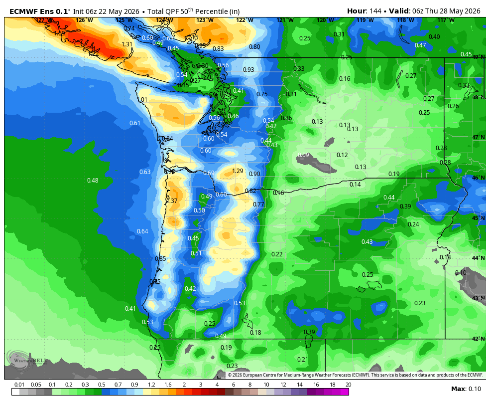
Much, much, much more interesting weather is forecast on Monday. A cold front sweeps inland with rain from mid-morning on. Up in the mountains, 0.5” to 1.0” is forecast between Monday and Tuesday. Down here, look at the image for your rain forecast. There is likely to be a brief period of heavy rain west of Hood River mid-morning, heavy enough to make your commute unpleasant. Other pleasant/unpleasant Monday news: very strong west wind all through the Gorge. Temps end up in the low 60s to the west and nearly 80 in the desert. Hence the wind. Showers and cool temps continue into Tuesday. After that, consensus decreases. There’s some hint of much warmer weather to start June, but uncertainty is quite high. So, let’s leave it there for now. Safe travels. -TATAS
HEY! DON’T STOP READING! Is this community-focused forecast helpful to you? It sure is! It takes me a couple hours a day to write. Please join your friends and neighbors in contributing to keep it going. Venmo: @thegorgeismygym PayPal: twomirrors@gmail.com USPS: Temira / PO Box 841 / Hood River, Oregon 97031 You can test out the forecast subscription for a few days for free by signing up below. Easy! Do it!
MT HOOD SNOW FORECAST

QR codes and links for end-of-season tips – thank you!!!
Cash/check: Temira – PO BOX 841 – Hood River, Oregon 97031

