

GORGE WIND FORECAST
If you’re still seeing yesterday’s and it’s after 9am, try opening this in an incognito window AND/OR FLUSHING YOUR CACHE or do a do a hard refresh (Ctrl+Shift+R / Cmd+Shift+R)
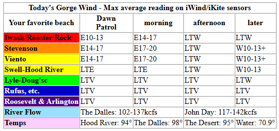
Keep in mind that this forecast attempts to predict what the iKite/iWind sensors will read. Think like a local! All sensors are not equal. Swell reads low. Viento/Arlington/The Wall read high compared to Swell. 30mph at Rufus (The Wall sensor) is about 23-24mph at Swell. 30mph at Swell is about 35-37mph at Rufus/Viento/Arlington. Hope that helps!
SHORT-TERM gorge wind forecast

Hi friends! East wind this morning gives way to (if we’re lucky – more on that later) west wind this afternoon. Moderate westerlies Thursday give way to stronger westerlies that start Friday and linger until the middle of next week. If Murphy’s Law kicks in, it’ll be windy every day until the 16th, ‘cuz I”ll be on a retreat in California for a program I’m in. Before I forget… some of you may want to mountain bike. As of yesterday, all Green Mountain lands are closed. This means you should consider Underwood and Hospital Hill and Whoopdee closed as well – they generally close at the same time.
Looking at Wednesday, we started with pressures of 29.90/29.94/29.95 for offshore gradients. East wind was 14-17mph between Stevenson and Viento to start the day with 10-13mph at Iwash/Rooster Rock and air quality horrific at 250+. Easterlies linger into early afternoon, when they’ll fall to 10mph at all launch spots between Iwash and Viento. Models suggest westerlies will return this evening at 10-15mph. However, smoke in the desert may limit heating, and this may delay / lessen the return of west wind. River flow over the last 24 hours was 102-142kcfs, river temp is 70.9F, and high temp forecast is somewhere in the 85-95 degree range depending on smoke impacts.

RIVER FLOW FOR SITES BETWEEN AVERY (EAST OF THE DALLES) AND RUFUS: CLICK HERE FOR JOHN DAY DAM FLOW.
RIVER FLOW FOR SITES BETWEEN STEVENSON AND DOUG’S BEACH (WEST OF THE DALLES): CLICK HERE FOR THE DALLES DAM FLOW

LONGER-TERM gorge wind forecast
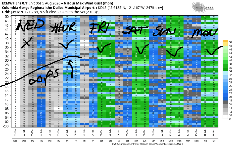
Hottest temps shift to the desert on Wednesday which allows west wind to settle in. Early wind will be 17-20mph from Viento to the Hatch. Give it a couple hours, and it’ll fill in from Stevenson to Mosier. If desert heating manages to overcome smoke limitations, we’ll see 19-22mph from Stevenson to Avery in the afternoon with 13-16mph at Rufus. High temps: mid 90s in Hood River.
The persistent onshore/west flow really starts to clear out the smoke on Friday which allows for greater certainty about temps and wind. Early westerlies will be 21-24mph from Viento to Hood River with 10-13mph east of Hood River to Arlington. Midday wind builds to 22-25mph from Stevenson to Doug’s with 17-20mph at Avery and 13-16mph at Rufus. Afternoon: 22-25mph from Stevenson to Mosier (less at the Hatch), and 24-27mph from Avery to Arlington. High temps: 93 in Hood River and 100 in the desert.
We turn to the Euro Ensemble for some help on Saturday. It thinks Saturday will be a bit stronger than Friday. Sunday’s strength looks right in the middle of Friday and Saturday, and Monday looks about the same. In other words, we’re likely to see 22-25mph or better Saturday, Sunday, and Monday. Westerlies at 17-20mph or more are likely to persist through Wednesday. After that, model uncertainty increases, and I’m not hazarding any guesses. Hope to see you on the Nch’i Wana soon!
Tip via venmo, cash or check
Want to subscribe to the email version, support Temira, and get the forecast earlier? Click on the blue box up above or use the methods below. Year-round is $29.99 or more if you think it’s worth more. Only need snow or only need wind? Warm season (May-Oct) or cold season (Nov-Apr) is $19.99 or more if you think it’s worth more. Thanks for your support!

JONES BEACH, SAUVIE ISLAND, & COAST FORECAST
Wind northerly unless otherwise indicated. For coast, it’s North/Central/South with the “central” at approximately Florence. Swell forecast from NWS for central coast. Jones: westerly unless otherwise stated. Sauvie Island: northerly unless otherwise stated.
Coast Wednesday: 15-20/15/15???, N swell 6′ at 7 seconds. Thursday: 10-15/20/20-25, NW 5′ @ 8. Friday: 10-15/20/25-30, N 5′ @ 7. Jones Wednesday: 16-19. Thursday: 17-20. Friday: 17-20. Sauvie Island Wednesday: 11-14. Thursday: 11-14. Friday: 12-15.
BARE BONES HOOD RIVER WEATHER FORECAST
Smoky AF today. Temps start in the low 50s and rise to, well, nobody knows with the smoke, but probably 90+. Light easterlies this morning. Light westerlies late in the day. No rainbows. Thursday will be smoky but getting less. Temps start in the mid 50s and rise to the low-mid 90s. Moderate westerlies. No rainbows. Friday finally brings clear air. Temps start in the low 60s and rise to the low 90s. Moderately strong westerlies. No rainbows. No rain in sight for the next couple of weeks.
BIKE TRAILS INFO
NEXT WORK PARTY: August 15th and September 5th on the 133 trail in Post Canyon. Meet at Post Flats Staging Area at 9am. Hosted by Hood River County.
CLOSED TRAILS: Anything south of the 44 Road due to the Grasshopper Fire / Forest Closure Order: for example – Boulder Lakes, Gunsight, Gumjuwac, Lookout Mountain, 450, Fifteenmile. ALL GREEN MOUNTAIN LANDS: Underwood Mountain, Whoopdee Trail. Consider Kreps lands (Hospital Hill) closed as well – they usually close at the same time as Green Mountain.
TEMIRA’S AWESOME TRAVEL ADVISORY SERVICE
HYPERLOCAL WEATHER FORECAST FOR THE COLUMBIA GORGE
THE DALLES, HOOD RIVER, WHITE SALMON, TROUT LAKE, STEVENSON, CASCADE LOCKS, PARKDALE, ODELL, HUSUM, BZ, MILL A, WILLARD, GOLDENDALE, RUFUS, ARLINGTON, boardman
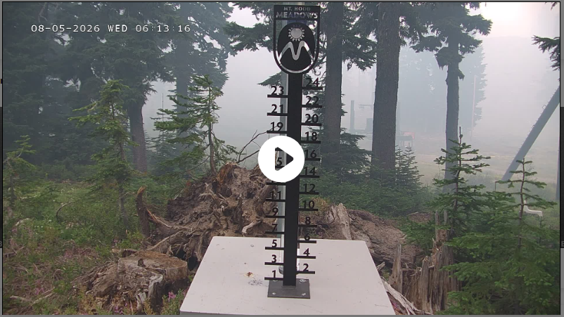
Good morning, neighbors! It’s a bit shit out there this morning thanks to smoke from the Grasshopper Fire. That beast is now 39,439 acres, but as of 4am, had not made it to Highway 35. Fingers crossed!!! We’ll see the wind switch from easterly to westerly late today – that’ll help our fire crews. Air quality will slowly improve west of The Dalles once the west wind returns. We probably won’t be back to Awesome Air until Friday morning, and shit air will persist east and south of The Dalles for the extended future depending on the exact direction of west wind. Any south in it will send Grasshopper smoke into the eastern Gorge. Other weather news: high temps remain hot, 90+, through Friday.
Today’s Gorge weather forecast + Glenwood and all our friends around the world
Wednesday kicked off nice and cool: 40 degrees in Glenwood and upper 40s to mid 50s most other places. AQI readings ranged from 175ish in The Dalles to 250-500 in Hood River, 200ish in Stevenson, Trout Lake, and Goldendale, and 1500+ in Parkdale and Govy. Forecast highs today range from 94 on the west side to 98 in The Dalles and 94 in Pasco. Given the density of the smoke, we’re probably going to fall short of those highs. Wind will be E 15-20mph this morning near Iwash (wanker) Rock and Stevenson. The wind goes calm early afternoon and switches to westerly at 10mph this evening between Stevenson and The Dalles with light wind east of there.
Before we look at Thursday’s forecast, let’s check in with our friends:
Bandar-e Mahshahr, Iran: 109, sunny, 29% humidity
Havana, Cuba: 84, partly cloudy 79% humidity
Muscat, Oman: 95 partly cloudy, 53% humidity
Caracas, Venezuela: 75, partly cloudy, 79% humidity
Nuuk, Greenland: 49, partly cloudy, 90% humidity
Gaza City: 87, sunny, 65% humidity
Ottawa, Canada: 71, sunny, 75% humidity
Back to the Gorge…
Thursday’s Gorge weather forecast
Wednesday night and Thursday morning look pretty dang smoky east of Cascade Locks due to both the Lava Fire (small) and the Grasshopper Fire (ginormous). We’ll start Thursday with temps at 50-60 degrees and west wind at 15mph between Viento and Hood River. Afternoon brings vast improvement in air quality west of The Dalles, but areas east of The Dalles as well as south Wasco, Sherman, and Gilliam Counties will remain mired in smoke from the Grasshopper Fire. Thursday highs range from 94 to the west and 100 in The Dalles. Westerlies build to 20mph between Stevenson and Avery with 15mph near Rufus.
Friday’s Gorge weather forecast
The latest smoke forecast only runs through the wee hours of Friday, when the air will be great west of The Dalles and shit in the places it was shit on Thursday afternoon. On Friday morning, we wake to temps of 55-65 degrees and no clouds. West wind will be 20mph at dawn between Viento and Hood River with 10-15mph east to Arlington. Afternoon brings westerlies at 20-25mph between Stevenson and Rufus with Arlington getting windy too in the evening. Highs: 93-100F, warmest from The Dalles into the desert.
Extended Gorge weather forecast
We’ll lose about 5 degrees of heat on Saturday and another 5 degrees of heat on Sunday. Both days bring westerlies at 20-25mph. Air quality, barring any new fire starts to the west, should stay good west of The Dalles. To the east and south, smoke from the Grasshopper fire will continue to impact your life. With no rain forecast in the next couple of weeks (and thankfully no thunderstorms), there is no end in sight to smoke/fire season. Stay safe out there. -TATAS
HEY! DON’T STOP READING! Is this community-focused forecast helpful to you? It sure is! It takes me a couple hours a day to write. Please join your friends and neighbors in subscribing / contributing to keep it going. Venmo: @thegorgeismygym PayPal: twomirrors@gmail.com USPS: Temira / PO Box 841 / Hood River, Oregon 97031
MT HOOD SNOW FORECAST

QR codes and links for end-of-season tips – thank you!!!
Cash/check: Temira – PO BOX 841 – Hood River, Oregon 97031