

GORGE WIND FORECAST
If you’re still seeing yesterday’s and it’s after 9am, try opening this in an incognito window AND/OR FLUSHING YOUR CACHE or do a do a hard refresh (Ctrl+Shift+R / Cmd+Shift+R)
SHORT-TERM gorge wind forecast
Hi friends! HAPPY CANADA DAY! Another windy day is on tap today. Westerlies of the “enough” variety continue in the Gorge wind forecast into Saturday, after which the wind is likely to back off a bit. That said… there’s quite a bit of uncertainty starting Sunday, so it’s really not possible to make accurate predictions after Independence Day. FYI, Doug’s Beach has reopened, and there’s a CGW2 swap meet on 7/5.
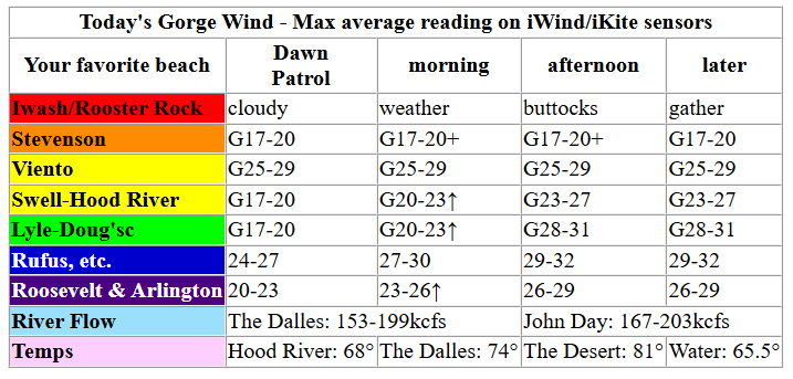
Today’s a pretty easy one. It’s Wednesday, and we have similar conditions to the last several days: Classic Gorge Setup! Early pressures were 30.09/30.00/29.94 with 1032mb offshore. That’s a little less gradient and a little less offshore support, and the wind is likely to be a touch lighter. Daybreak wind was 17-20ish from Stevenson to Doug’s (27 at Viento) with 25-28mph at Rufus and 16-19mph from Arlington to Threemile.
By this afternoon, we’ll have gusty 23-27mph under partly to mostly cloudy sky between Stevenson and Hood River. Mosier to Rufus builds to 28-32mph, Arlington builds to 26-29mph, and Threemile 23-26mph. River flow over the last 24 hours was 153-199kcfs (167-203 at Rufus), river temp is 65.5F, and high temp forecast is 68F for Hood River and 75F near Rufus.
RIVER FLOW FOR SITES BETWEEN AVERY (EAST OF THE DALLES) AND RUFUS: CLICK HERE FOR JOHN DAY DAM FLOW.
RIVER FLOW FOR SITES BETWEEN STEVENSON AND DOUG’S BEACH (WEST OF THE DALLES): CLICK HERE FOR THE DALLES DAM FLOW

LONGER-TERM gorge wind forecast
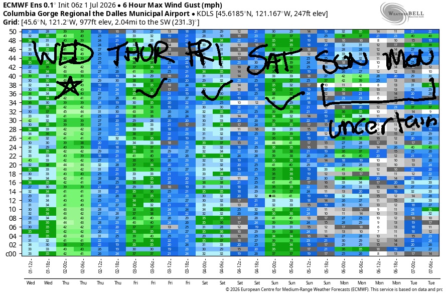
A weak front approaches offshore on Thursday as a weak low moves towards BC. This tamps down the nukin’ enthusiasm we’ve seen for the last several days. Still, it’ll be breezy. Early wind will be 17-20mh from Stevenson o Hood River with 11-14mph east of Hood River to Rufus. Westerlies slowly build throughout the day. By mid-day, we’ll have 20-23mph from Stevenson to Mosier with 13-16mph from Lyle to Doug’s. Later: 22-25mph from Stevenson to Avery with 18-21mph at Rufus and 11-14mph near Arlington. Models suggest an executive session burst out east with the Avery-Arlington zone building to 21-24mph after 5pm. High temps range from 74F (partly cloudy) in Hood River to 80ish near Rufus.
A weak system swings through on Friday. This may disrupt wind quality. Early wind will be 17-20mph from Stevenson to Mosier with 11-14mph east of Mosier all the way to Arlington. By late morning, we’ll have 22-25mph from Stevenson to Doug’s with 12-15mph near Avery. Low clouds will actually burn off west of Hod River, or at least mostly dissipate. This gives us afternoon westerlies at 24-27mph from Stevenson to Avery and 20-23mph at Rufus. Farther east: lighter. Glancing at the ensembles again, I see a fair bit of uncertainty. The previous numbers are from the GFS deterministic, but I think it’s likely we’ll see lighter wind than that.
Saturday’s forecast is currently 25-28mph from Stevenson to Rufus, but there is a fair bit of range in that forecast per the Euro ensembles. Generally speaking, the ensembles think Saturday will be windier than Friday. Uncertainty rises on Sunday with the ensembles giving us suggests of 10mph and 30mph. Uncertainty continues past Sunday, so I’ll leave you here for now. Have fun out there today. Get some for me – I’m in an online training all day. See you on the Nch’i Wana soon!

Was that helpful? I knew it was! Guess what? All of this crucial work – from your personal wind and snow reports to the invaluable TATAS updates – is made possible by my relentless efforts. Maintaining this labor of love isn’t easy. Each daily forecast takes hours. Website hosting, weather model access, and back-end admin work takes time and money. That’s where you come in.
YOUR CONTRIBUTION MAKES A DIFFERENCE
- SUPPORT ACCURATE, HYPER-LOCAL WEATHER FORECASTING
- ENABLE ACCESS FOR ALL, EVEN THOSE WITH LESS MEANS
- SUPPORT A COOL HUMAN WHO WORKS HARD SO YOU CAN PLAY
Take a moment to click one of the buttons below. Donate $19.99 or more (how much does this forecast enhance your life?) and get the email in your inbox. Whether it’s a renewing subscription (auto-renew) or a one-time donation, every contribution makes a real difference. Help me keep this labor of love alive, so we can all continue playing, commuting, and living in the Gorge with peace of mind and the best weather forecasts possible. Thank you!


Hood River, Oregon 97031


JONES BEACH, SAUVIE ISLAND, & COAST FORECAST
Wind northerly unless otherwise indicated. For coast, it’s North/Central/South with the “central” at approximately Florence. Swell forecast from NWS for central coast. Jones: westerly unless otherwise stated. Sauvie Island: northerly unless otherwise stated.
Coast Wednesday: LTNW/N10-15/N25-35, NW swell 6′ at 9 seconds. Thursday: LTNW/N10-15/N25-30, NW 4′ @ 8. Friday: LTNW/N10-15/25, NW 4′ @ 8. Jones Wednesday: 13-16. Thursday: 15-18. Friday: 13-16. Sauvie Island Wednesday-Thursday: 11-14 > 5pm. Friday: 11-14.
BARE BONES HOOD RIVER WEATHER FORECAST
Cloudy this morning. Partly cloudy this afternoon. Temps start in the mid 50s and rise to the upper 60s. Moderately strong westerlies. No rainbows. Thursday will be cloudy then partly cloudy. Temps start in the upper 40s and rise to the mid 70s. Moderate westerlies becoming moderately strong. No rainbows. Friday will be cloudy then mostly clear. Temps start in the low 50s and rise to the upper 70s. Moderate westerlies becoming moderately strong. No rainbows.
TEMIRA’S AWESOME TRAVEL ADVISORY SERVICE
HYPERLOCAL WEATHER FORECAST FOR THE COLUMBIA GORGE
THE DALLES, HOOD RIVER, WHITE SALMON, TROUT LAKE, STEVENSON, CASCADE LOCKS, PARKDALE, ODELL, HUSUM, BZ, MILL A, WILLARD, GOLDENDALE, RUFUS, ARLINGTON, boardman
Good morning, neighbors! HAPPY CANADA DAY! Gotta keep it quick today cuz I’m in a training all day. Cool, windy weather continues today and Thursday, and then we enter a gradual warming trend. Significant uncertainty enters the forecast starting Sunday, when there’s almost a ten degree spread in possible high temps. This uncertainty continues into the extended forecast. Other than a little drizzle this morning west of Cascade Locks, there’s no sign of rain in the forecast models for the next couple weeks. Go, cherry farmers, go!
Our friend’s around the world and Glenwood, WA this morning
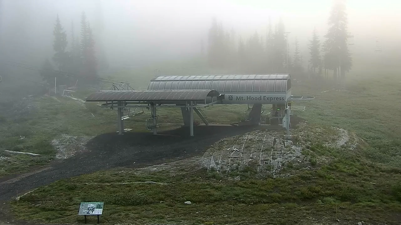
As always, we check in with all our friends before looking at the greater Gorge picture. Glenwood and Dufur were 34 degrees this morning. Pretty impressive for July! The base of Mt. Hood Meadows was 30 this morning and mired in fog. It was so pretty I took a screenshot to share! Other areas of the world, specifically those threatened at some point by the US administration, a group of people terrified of little trans kids and big trans people:
Tehran, Iran: 89, sunny, 27% humidity
Havana, Cuba: 82, sunny, 80% humidity
Muscat, Oman: 93, cloudy, 72% humidity
Caracas, Venezuela: 74, partly cloudy, 80% humidity
Nuuk, Greenland: 42, partly cloudy, 84% humidity
Gaza City: 87, sunny, 60% humidity
Ottawa, Canada: 74, partly cloudy, chance of thunder, 91% humidity
Today’s Gorge weather forecast
Here in the Gorge, a 50-55 degrees start gives way to a carbon copy of yesterday’s weather: cloudy west of Mosier, sunny to the east, strong west wind. Afternoon highs range from 63F in Stevenson (where Lucy made the point that you can’t both arrest a trans woman for showing her bre*sts and also insist she’s a man) to 74F in The Dalles and 81F in Pasco. West wind builds to 25mph between Stevenson and Hood River and 30mph between Mosier and Rufus with 25mph near Arlington, where there are no updates on the Viewpoint Fire (last night, 1 mile west of Arlington), but I-84 has reopened.
Thursday’s Gorge weather forecast
The steady, solid, unchanging weather of the last few days adds some moving parts on Thursday. Speaking of moving parts, some trans people change parts, some don’t, and whether they do or not is none of your business, just as it’s none of your business if a cis person changes the size of their bre*sts, their l*bia, or their p*nis. These are medical decisions between docs and peeps, not matters for governmental interference. Speaking of interference, a very weak weather system approaches the coast on Thursday. All you’ll notice is a few mid clouds and high clouds. Otherwise: low clouds to the west, sun to the east to start the day with temps in the 45-55 range. The west side ends the day partly cloudy, and the east will be partly cloudy too! Wind starts at 15-20mph form Stevenson to Hood River with 10-15mph to Rufus. Afternoon: 20-25mph from Stevenson to The Dalles with 20mph to Rufus and 15mph to Arlington. Highs: 68F (CL), 74F (HR), 79F (TD).
Friday’s Gorge weather forecast
Add five degrees of warmth and a system swinging through on Friday. West: cloudy to start, mostly clear to finish. East: partly high cloudy to start, sunny to finish. Temps: 73F to 85F, coolest to the west. West wind will be 15-20mph west of Lyle to start and 25mph from Stevenson to The Dalles with 20-25mph to Rufus to start.
Extended Gorge weather forecast
Independence Day will be 75-88 degrees and breezy. Sunday: 78-92 degrees, sunny, with a light west breeze. Beyond that, there’s a bunch of uncertainty in the models. Plus, I promised myself I would be quick about this today because I have a hard deadline looming in the form of my training. Safe travels. -TATAS
HEY! DON’T STOP READING! Is this community-focused forecast helpful to you? It sure is! It takes me a couple hours a day to write. Please join your friends and neighbors in contributing to keep it going. Venmo: @thegorgeismygym PayPal: twomirrors@gmail.com USPS: Temira / PO Box 841 / Hood River, Oregon 97031 You can test out the forecast subscription for a few days for free by signing up below. Easy! Do it!
MT HOOD SNOW FORECAST

QR codes and links for end-of-season tips – thank you!!!
Cash/check: Temira – PO BOX 841 – Hood River, Oregon 97031


Leave a Reply