

GORGE WIND FORECAST
If you’re still seeing yesterday’s and it’s after 9am, try opening this in an incognito window AND/OR FLUSHING YOUR CACHE or do a do a hard refresh (Ctrl+Shift+R / Cmd+Shift+R)
SHORT-TERM gorge wind forecast
Hi friends! Guess what? It’s going to be big at Rufus again today! Ideal near-east/eastern Gorge conditions persist for one more day as a stable setup continues over the Pacific Northwest. Moving pieces impact quality and knock down the strength starting Wednesday, but westerlies of some sort continue through the July 4th and Canada Day holiday weekend. Announcements: Doug’s Beach remains closed due to the Lyle Hill fire. There may be planes scooping, so don’t cruise downwind from Rowena into that area. Next, there’s a CGW2 swap meet on the Hood River waterfront on Sunday, 8am-12pm (sellers arrive starting at 7am).
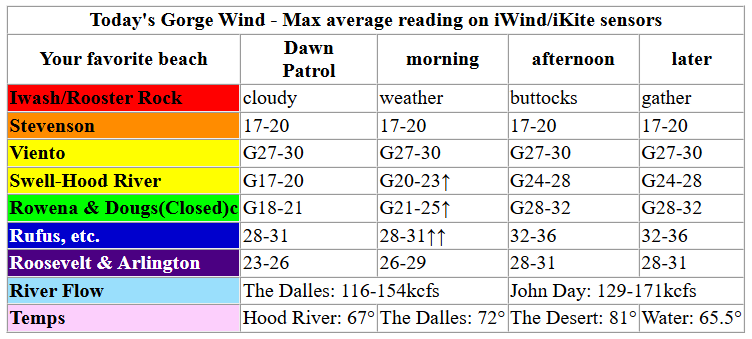
This morning (Tuesday) started with pressures of 30.09/29.97/29.90 aided by 1036mb (!!!) offshore and an afternoon desert heat low. Wind was already 30-35mph at Rufus at dawn with 23-26mph at Arlington and 20ish mph west of The Dalles. Marine clouds persist all day west of Mosier or perhaps west of the Hatch. East of Hood River, once again, westerlies build to 32-26mph from Lyle to Rufus by mid-morning (okay, it’s already 30-35mph at Rufus) with 28-31mph at Arlington. Threemile: 23-26mph eventually building to 26-29mph. That wind, near-east and eastern Gorge, holds into the evening.
Things are a little trickier in the western Gorge where the gradient is there (0.12 this morning) but so are the clouds. Early wind was 17-20mph at Stevenson, Swell, and Hood River (and Mosier?). Models suggest a slow and steady build to gusty 24-28mph between Viento and Mosier with gusty 17-20mph at Stevenson all day. If the clouds persist, the wind will be very up-and-down with big holes and gusts. Want lighter wind? Get on the water early somewhere in the Gorge (but not Rufus- it was blasting early), and get off the water early too! Stats: river flow over the last 24 hours was 116-171kcfs (129-171 at Rufus with that 171 reading this morning at 6am). River temp is 65.5F. High temp forecast is SIX-SEVEN degrees in Hood River and mid 70s in the desert.
RIVER FLOW FOR SITES BETWEEN AVERY (EAST OF THE DALLES) AND RUFUS: CLICK HERE FOR JOHN DAY DAM FLOW.
RIVER FLOW FOR SITES BETWEEN STEVENSON AND DOUG’S BEACH (WEST OF THE DALLES): CLICK HERE FOR THE DALLES DAM FLOW

LONGER-TERM gorge wind forecast
Wednesday, CANADA DAY!!! starts with low clouds to the west and sun to the east and dawn patrol wind at 19-22mph from Stevenson to Arlington. Models suggest the clouds will burn back some, which gives us a period of 25-28mph from Viento to Doug’s (closed) in the morning. Stevenson: 20ish mph depending on cloud cover. Afternoon holds the 25-28mph from Stevenson to Doug’s and brings 28-31mph from Avery to Rufus. As the clouds burn back further, the 28-31mph wind fills in from Lyle east to Rufus with 22-25mph at Arlington. There are signs in the models that the Hatch may under-perform from late morning on, so be prepared to relocate if that happens. That said… given the persistent clouds, I’m skeptical of the Hatch dying off. High temps: 68F in Hood River and mid 70s in the desert.
A weather feature swings through on Thursday and disrupts the streak of strong wind. Early westerlies will be light at Stevenson, 17-20mph from Viento to the Hatch, and 7-10mph east of the Hatch (or east of Hood River) to Arlington. We’ll see a slow build to 15-18mph from Stevenson to Hood River with 20-23mph from Mosier to Avery in the afternoon. Farther east: probably 15mph or so. High temps range from 73F in Hood River to 80ish in the desert.
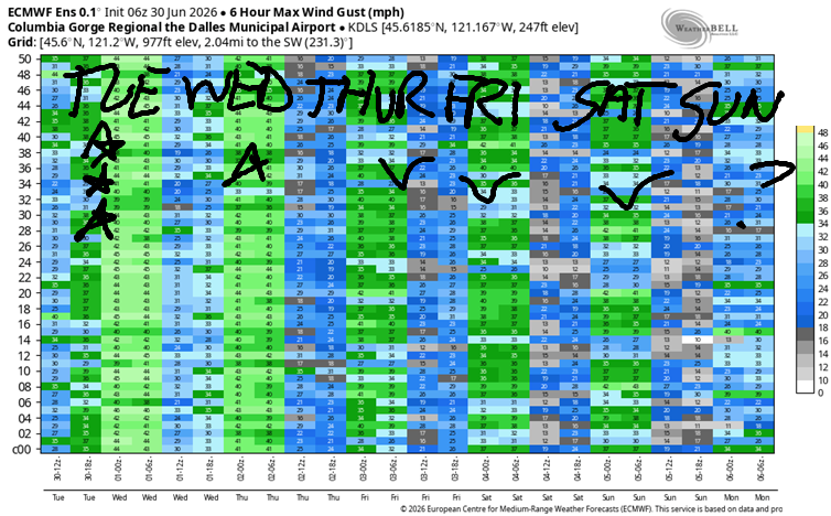
Looking deeper into the future… Forecast accuracy and reliability decreases due to increased uncertainty in the models. Generally speaking, the Euro ensembles call for 20+ mph somewhere in the Gorge Friday and Saturday with somewhat lesser wind on Sunday. Uncertainty builds beyond Sunday, but the Euro generally likes the idea of westerlies continuing. That said, if you want it nuking, get it today and Wednesday, because all the following days contain less wind than “nuking”. Which is probably a relief to many of you! Have fun out there. See you on the Nch’i Wana soon!

Was that helpful? I knew it was! Guess what? All of this crucial work – from your personal wind and snow reports to the invaluable TATAS updates – is made possible by my relentless efforts. Maintaining this labor of love isn’t easy. Each daily forecast takes hours. Website hosting, weather model access, and back-end admin work takes time and money. That’s where you come in.
YOUR CONTRIBUTION MAKES A DIFFERENCE
- SUPPORT ACCURATE, HYPER-LOCAL WEATHER FORECASTING
- ENABLE ACCESS FOR ALL, EVEN THOSE WITH LESS MEANS
- SUPPORT A COOL HUMAN WHO WORKS HARD SO YOU CAN PLAY
Take a moment to click one of the buttons below. Donate $19.99 or more (how much does this forecast enhance your life?) and get the email in your inbox. Whether it’s a renewing subscription (auto-renew) or a one-time donation, every contribution makes a real difference. Help me keep this labor of love alive, so we can all continue playing, commuting, and living in the Gorge with peace of mind and the best weather forecasts possible. Thank you!


Hood River, Oregon 97031


JONES BEACH, SAUVIE ISLAND, & COAST FORECAST
Wind northerly unless otherwise indicated. For coast, it’s North/Central/South with the “central” at approximately Florence. Swell forecast from NWS for central coast. Jones: westerly unless otherwise stated. Sauvie Island: northerly unless otherwise stated.
Coast Tuesday: LTNW/LTNW/N25-35, NW swell 7′ at 10 seconds. Wednesday: LTNW/N10/N25-35, NW 6′ @ 9. Thursday: LTNW/NW10/N25-30, NW 4′ @ 8. Jones Tuesday: 7-10. Wednesday: 11-14. Thursday: 14-17. Sauvie Island Tuesday: NW13-16. Wednesday: NW 10-13. Thursday: N10-13.
BARE BONES HOOD RIVER WEATHER FORECAST
Mostly cloudy this morning. Partly cloudy this afternoon. Temps start in the mid 50s and rise to the upper 60s. Moderately strong westerlies. No rainbows. Wednesday will be cloudy then partly cloudy. Temps start in the upper 40s and rise to the upper 60s. Moderate westerlies early. Strong later. No rainbows. Thursday will be partly cloudy. Temps start in the upper 40s and rise to the low 70s. Moderate westerlies. No rainbows.
TEMIRA’S AWESOME TRAVEL ADVISORY SERVICE
HYPERLOCAL WEATHER FORECAST FOR THE COLUMBIA GORGE
THE DALLES, HOOD RIVER, WHITE SALMON, TROUT LAKE, STEVENSON, CASCADE LOCKS, PARKDALE, ODELL, HUSUM, BZ, MILL A, WILLARD, GOLDENDALE, RUFUS, ARLINGTON, boardman
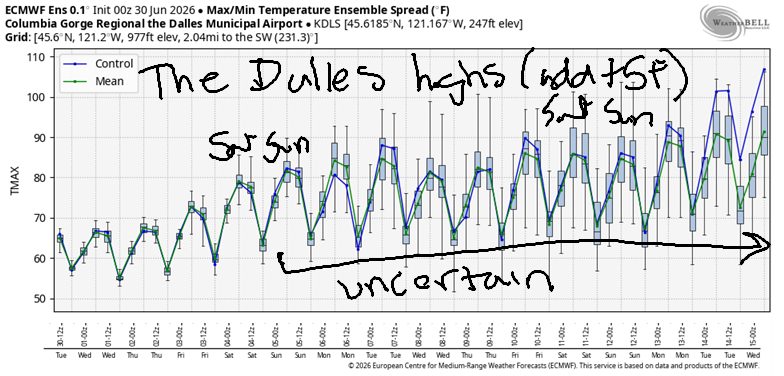
Good morning, neighbors! Happy day before Canada Day! Today and tomorrow are the days we celebrate all things Canadian and also have happiness for Canadians enjoying these things (among others): Hawkins Cheezies, Coffee Crisp candy bars, Timmy Hortons, niceness, and universal healthcare. Weather-wise: today (Tuesday) is pretty much a carbon copy of Monday, weather-wise, anyway. Hopefully something else will change, perhaps in the realm of kindness. It would be super cool if today was the day that everyone realized being kind was nicer than acting on anger and acting out of ill-will! Maybe we can start something? Back to the weather outside our minds and hearts… cool conditions persist through Thursday, and then temps warm. By Independence Day (MAKE DEMOCRACY GREAT AGAIN!), temps will be in the 80-90F range all through the Gorge.
First, let’s look at our friends around the world:
Tehran, Iran: 91, sunny, 24% humidity
Havana, Cuba: 83, sunny, 80% humidity
Muscat, Oman: 93, sunny, 71% humidity
Caracas, Venezuela: 73, partly cloudy, chance of rain, 87% humidity
Nuuk, Greenland: 41, cloudy, 83% humidity
Gaza City: 86, sunny, 60% humidity
Ottawa, Ontario, Canada: 69F, partly cloudy, 77% humidity
Now, looking closer to home, we see…
Most of us started Tuesday in the 45-60F range. Glenwood over-performed once again with a 40 degree start. Today, all through the Gorge, will be a day to open the windows and leave them open. Temps rise to SIX-SEVEN degrees in Hood River, 72F in The Dalles, and 81F in Pasco. Clouds persist west of Mosier, and the sky clears in the desert. Wind: blasting, again. Afternoon sees 20-30mph between Stevenson and Mosier with 30-40mph from Lyle to Arlington. Farther east (I initially typed “farter”, which is funnier, because who doesn’t like farts and the people who make them, which, btw, includes YOU?), wind will be 20-25mph. Some of you west of Cascade Locks may pick up a trace of drizzle this morning.
Canada Day looks nearly identical but maybe 5mph less windy.
On Thursday, a weak shortwave (it’s a weather Thing) swings through. You probably won’t notice anything other than an increase in mid and high clouds and a decrease in the wind. Morning temps; 45-60. Afternoon highs: 70-82, with 78F in The Dalles. Wind: 15-20mph west of Mosier and 20-25mph from Mosier to Avery with less to the east.
On Friday, folks west of Mosier start cloudy, and folks to the east start sunny. Morning temps will be 45-60. Afternoon highs: 75-86 with 84F in The Dalles. Wind will be 20-25mph west of Avery and less to the east. Saturday and Sunday look warmer. Saturday brings westerlies at 20-25mph, and Sunday 15-20mph. Looking at this forecast (well, okay, I’m actually writing it), I’m thinking I’d better get up in the garden and do all the weeding I can prior to the sun and heat returning. You do the same! Cherry farmers: no rain is forecast for the next couple of weeks, yay! Happy picking. Safe travels. -TATAS
HEY! DON’T STOP READING! Is this community-focused forecast helpful to you? It sure is! It takes me a couple hours a day to write. Please join your friends and neighbors in contributing to keep it going. Venmo: @thegorgeismygym PayPal: twomirrors@gmail.com USPS: Temira / PO Box 841 / Hood River, Oregon 97031 You can test out the forecast subscription for a few days for free by signing up below. Easy! Do it!
MT HOOD SNOW FORECAST

QR codes and links for end-of-season tips – thank you!!!
Cash/check: Temira – PO BOX 841 – Hood River, Oregon 97031


Leave a Reply