

GORGE WIND FORECAST
If you’re still seeing yesterday’s and it’s after 9am, try opening this in an incognito window AND/OR FLUSHING YOUR CACHE or do a do a hard refresh (Ctrl+Shift+R / Cmd+Shift+R)
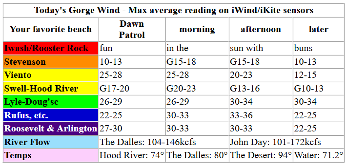
Keep in mind that this forecast attempts to predict what the iKite/iWind sensors will read. Think like a local! All sensors are not equal. Swell reads low. Viento/Arlington/The Wall read high compared to Swell. 30mph at Rufus (The Wall sensor) is about 23-24mph at Swell. 30mph at Swell is about 35-37mph at Rufus/Viento/Arlington. Hope that helps!
SHORT-TERM gorge wind forecast

Hi friends! It’s Saturday, and a windy day is on tap, especially out in the desert. Low clouds pushed so far inland overnight that they squashed the Hatch dawn patrol. But don’t you worry – there’s dawn patrol at 25mph+ everywhere between Mosier and Arlington, and the wind is ramping up! It’s going to be a windy day! Sunday also looks like a solid west wind day. High pressure builds inland on Monday and pretty much shuts the wind off. That same high pressure might drive just-enough east wind for a few of you on Tuesday. As we move into Wednesday, uncertainty rises, but models are optimistic about solid westerlies returning Thursday and continuing after that. Fingers crossed! Remember that Doug’s is closed through August 5th due to railroad stuff. On to today’s forecast….
Sunday started out cloudy past Hood River (hence the lack of Hatch dawn patrol) with sunshine out east. Early pressures were 30.16/30.05/29.95 for gradients of 0.11 and 0.10, a great sign for widespread wind! We are expecting a cold front to swing through mid-morning. This may turn the wind gusty and up/down for a couple hours while it moves through. After it passes, high pressure will build offshore and a low will hang off the coast of Vancouver Island. All that’s to say that it’s going to be quite windy everywhere east of the low clouds. Given those clouds and the prediction for them to persist, areas west of Mosier will be up-and-down in the 20-23mph range into the afternoon (under 15mph in the evening) with the exception of Viento, which is likely to hover in the mid to potentially upper 20s.
East of The Dalles, westerlies quickly build to 30-33mph between Avery and Threemile and hold until 5pm or so. Periods of 33-36mph are possible, but not promised, between noon and 5pm. Boardman joins the fun at 30-33mph between 2pm and 5pm. After 5pm, the wind drops to 22-25mph from Philippi Canyon to Boardman and 17-20mph or less between Avery and Rufus. Conditions are a little trickier to predict between Mosier and Doug’s (closed), due to uncertainty about the extent of the clouds. Early wind will be 24-27mph near Rowena. It’s likely to fall mid-morning, return early afternoon, and fall late afternoon as clouds move inland. Most reliable conditions today will be east of the low clouds, probably east of The Dalles. River flow over the last 24 hours was 101-172kcfs, river temp is 71.2F, and high temp forecast is 74F (and mostly cloudy) in Hood River and 85-90 (and sunny) east of The Dalles.

RIVER FLOW FOR SITES BETWEEN AVERY (EAST OF THE DALLES) AND RUFUS: CLICK HERE FOR JOHN DAY DAM FLOW.
RIVER FLOW FOR SITES BETWEEN STEVENSON AND DOUG’S BEACH (WEST OF THE DALLES): CLICK HERE FOR THE DALLES DAM FLOW

LONGER-TERM gorge wind forecast
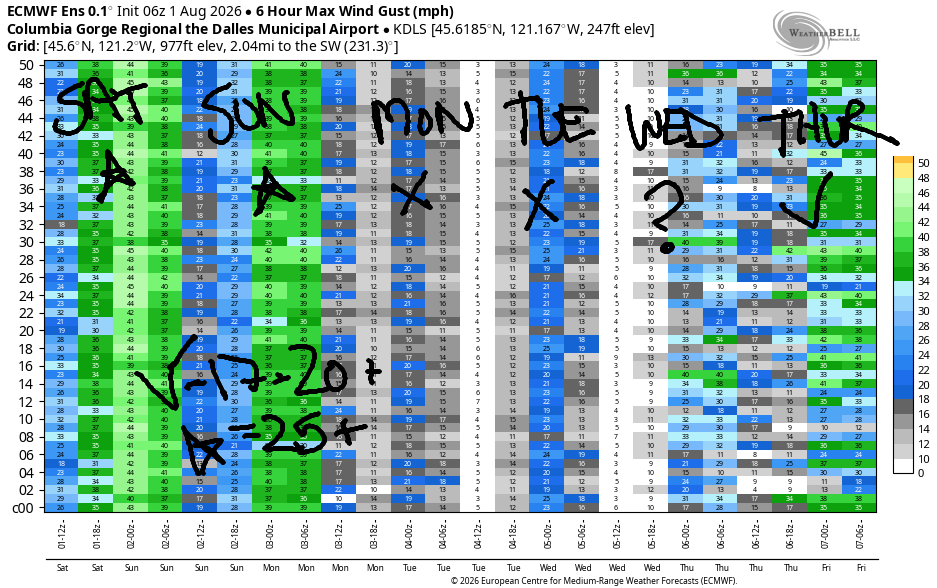
Sunday starts off cloudy to the west and sunny to the east with a trough moving inland and strong high pressure offshore. This is a setup where reality beats the GFS nearly every time. Early wind may be somewhat suppressed by cold temps. Let’s call it 15-18mph from Viento to Mosier. As the desert heats, westerlies build to 22-25mph from Stevenson to Doug’s. It’s possible, given lingering clouds on the west side, that Rufus could join, but it’s far from guaranteed. High temp: 74F in Hood River and 80F in the desert.
High pressure takes over on Monday and pretty much shuts things down. The wind will be calm to start, east 10-15mph for a few hours midday near Stevenson, and light easterly or calm to finish. High temp: 83F in Hood River and sunny. East flow continues on Tuesday as high temps jump 5 degrees. Easterlies peak at 20mph or so in the morning hours before fading in the afternoon.
As we move into Wednesday, uncertainty increases. The Euro ensemble hints at westerlies returning, but it’s unclear if that will actually happen. Models suggest the heat low will move inland on Thursday which would bring the westerlies back. Models do agree that offshore high pressure will linger – once the westerlies return, they should be relatively strong and steady thanks to the offshore high My fingers are crossed, especially since I’ll be on retreat for a week starting the 9th (not ideal, but it’s part of an 18-month program I’m in) and missing forecasting for you and playing in the Nch’i Wana. See you out there soon!
Tip via venmo, cash or check
Want to subscribe to the email version, support Temira, and get the forecast earlier? Click on the blue box up above or use the methods below. Year-round is $29.99 or more if you think it’s worth more. Only need snow or only need wind? Warm season (May-Oct) or cold season (Nov-Apr) is $19.99 or more if you think it’s worth more. Same for the cold season forecast. Thanks for your support!

JONES BEACH, SAUVIE ISLAND, & COAST FORECAST
Wind northerly unless otherwise indicated. For coast, it’s North/Central/South with the “central” at approximately Florence. Swell forecast from NWS for central coast. Jones: westerly unless otherwise stated. Sauvie Island: northerly unless otherwise stated.
Coast Saturday: LTW/NW10/N25-30, W swell 4′ @ 8 seconds. Sunday: 15-20/20-25/30-40, N 5′ @ 7 and NW 6′ @ 9. Monday: 20-25/25-30/35-40, NW 6′ @ 8. Jones Saturday: 10-13. Sunday: 12-15. Monday: 12-15. Sauvie Island Saturday: 13-16. Sunday: 12-15. Monday: 15-18.
BARE BONES HOOD RIVER WEATHER FORECAST
Mostly cloudy today (yay!). Temps start in the mid 60s and rise to the mid 70s. Moderately strong westerlies. No rainbows. Sunday will be partly cloudy then sunny. Temps start in the low 50s and rise to the mid 70s. Moderately strong westerlies. No rainbows. Monday will be partly cloudy then clear. Temps start in the low 50s and rise to the low 80s. Calm wind or light easterlies. No rainbows.
TEMIRA’S AWESOME TRAVEL ADVISORY SERVICE
HYPERLOCAL WEATHER FORECAST FOR THE COLUMBIA GORGE
THE DALLES, HOOD RIVER, WHITE SALMON, TROUT LAKE, STEVENSON, CASCADE LOCKS, PARKDALE, ODELL, HUSUM, BZ, MILL A, WILLARD, GOLDENDALE, RUFUS, ARLINGTON, boardman
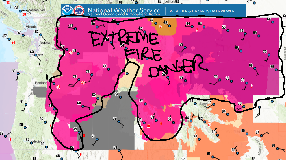
Good morning, neighbors! It’s Saturday, and a powerful-for-summer cold front swings through today. Result: cool, cloudy weather on the west side, drizzle west of Wyeth, and warm, very windy weather on the east side. Lingering impacts continue the cool, breezy weather on Sunday, and then we’re set for warmer conditions all through next week. If you need a not-windy day, Monday’s the one. Fire danger will be extreme today as this weather system swings through – east of the low clouds, westerlies pick up to 30+ mph. Be careful out there!
Glenwood this morning and our friends around the world
Saturday morning started quite warm in Glenwood: 64 degrees, just one degree shy of Medicare age. Wouldn’t it be great if “Medicare age” was 0 and everyone in this country had healthcare? I bet everyone in Glenwood would be stoked to have healthcare from birth to death! Anyone out there not want healthcare over the entire course of their life? Elsewhere in the world, many countries have universal healthcare. Iran: 90% population coverage by basic public health insurance; Cuba – 100% coverage; Oman – 100% coverage of citizens; Venezuela – free public healthcare is written into the Constitution; Greenland – everyone is covered; Gaza – in theory, there is free universal healthcare, but the destruction of the country and genocidal actions make it impossible to access; Canada – yes, yes, we all know Canada has universal healthcare! Only the USA does not!
Bandar-e Mahshahr, Iran: 114, sunny, 16% humidity
Havana, Cuba: 84, sunny, 81% humidity
Muscat, Oman: 101, partly cloudy, 33% humidity
Caracas, Venezuela: 75, partly cloudy, 80% humidity
Nuuk, Greenland: 50, cloudy, 87% humidity
Gaza City: 91, sunny, 57% humidity
Ottawa, Canada: 70, cloudy, 87% humidity
Today’s Gorge weather forecast
May you not have a health crisis today! If you do, here’s the weather you’ll have for it – cloudy to the west of Mosier and sunny to the east. Drizzle west of Wyeth between 2pm and 6pm. West wind picks up to 15-25mph (depending on location) west of Mosier with 30-35mph from Mosier to Boardman. High temps range from 72 in Stevenson, where it’s likely to rain from 2pm to 6pm, 74 in cloudy Hood River, 80 in sunny The Dalles, and 94 in Pasco.
Sunday’s Gorge weather forecast
Overnight, temps fall farther than normal thanks to +5C air at 850mb (5000′). If Glenwood is clear and calm, temps will fall into the mid 30s! Elsewhere: 45-55. The day starts mostly cloudy west of Mosier and sunny to the east. At least some low clouds linger west of Hood River into the evening. West wind will be 15mph to start the day and 25mph from Stevenson to Avery with 15-20mph near Rufus in the afternoon. Highs: 74/74/79/82, pretty damned pleasant all the way out into the desert and a nice respite from the heat!
Extended Gorge weather forecast
The respite from the heat won’t last long – Monday begins a warming trend, and by Wednesday, The Dalles will reach the upper 90s. Monday will be mostly sunny with highs from 83-88 degrees. We’ll have calm wind early, light easterlies midday, and very light or calm wind in the evening. Slightly stronger east wind is forecast on Tuesday when high temps will range from 90 to 94. Wednesday looks hotter, and Thursday looks like the hottest day of the week. Starting Friday, uncertainty increases, but there’s some indication of some cooling as we move into the following week (when TATAS will be gone).
Be careful out there today, folks. The fire danger will be extreme east of the low clouds and up in the hills, where we’re also expecting pretty strong west wind. Safe travels. -TATAS
HEY! DON’T STOP READING! Is this community-focused forecast helpful to you? It sure is! It takes me a couple hours a day to write. Please join your friends and neighbors in contributing to keep it going. Venmo: @thegorgeismygym PayPal: twomirrors@gmail.com USPS: Temira / PO Box 841 / Hood River, Oregon 97031 You can test out the forecast subscription for a few days for free by signing up below. Easy! Do it!
MT HOOD SNOW FORECAST

QR codes and links for end-of-season tips – thank you!!!
Cash/check: Temira – PO BOX 841 – Hood River, Oregon 97031