

GORGE WIND FORECAST
If you’re still seeing yesterday’s and it’s after 9am, try opening this in an incognito window AND/OR FLUSHING YOUR CACHE or do a do a hard refresh (Ctrl+Shift+R / Cmd+Shift+R)
SHORT-TERM gorge wind forecast

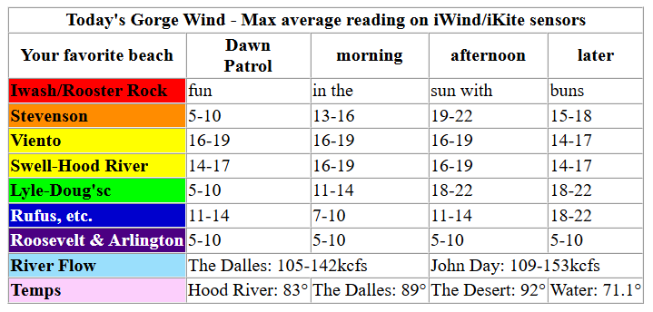
Hi friends! Every day this week looks windy enough to get at least some of you on the water. Strongest days will be Tuesday and Saturday, with Saturday likely to be steadier, stronger, and more widespread. Fingers crossed the ensembles don’t change their mind! We’re not looking at any extreme heat this week either – it’s going to be simply lovely out there on (and off) the Nch’i Wana!
Pressures today (Monday) started at 30.09/30.03/30.02 with clear sky in the metro area. Viento started the day with a reading of 17 on the iWind/iKite sensors. Everywhere else: under 10mph at dawn. Westerlies rise to 14-17mph between Stevenson and Mosier by mid-morning with 11-14mph from Lyle to Avery. Afternoon wind holds at 16-19mph from Stevenson to Mosier and rises to 18-22mph from Lyle to Rufus. River flow over the last 24 hours was 105-153kcfs, river temp is 71.1F, and high temp forecast is 83F in Hood River.
Keep in mind that this forecast attempts to predict what the iKite/iWind sensors will read. Think like a local! All sensors are not equal. Swell reads low. Viento/Arlington/The Wall read high compared to Swell. 30mph at Rufus (The Wall sensor) is about 23-24mph at Swell. 30mph at Swell is about 35-37mph at Rufus/Viento/Arlington. Hope that helps!
One more thing, not wind related: there’s a fundraiser at the Ruins in Hood River tonight (doors at 6pm) for the Hood River Ice Rink project. This would be an awesome addition to the community. If you don’t have anything going on, please go down there and support this!
RIVER FLOW FOR SITES BETWEEN AVERY (EAST OF THE DALLES) AND RUFUS: CLICK HERE FOR JOHN DAY DAM FLOW.
RIVER FLOW FOR SITES BETWEEN STEVENSON AND DOUG’S BEACH (WEST OF THE DALLES): CLICK HERE FOR THE DALLES DAM FLOW

LONGER-TERM gorge wind forecast
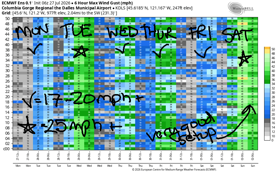
Tuesday gets a nudge from a weak weather system moving inland – this gives us supportive low clouds on the west side along with a reduction in temps west of The Dalles. Early wind will be 17-20mph from Viento to Arlington with under 10mph at cloudy Stevenson and 13-16mph near Rowena. Afternoon wind slowly builds to gusty 23-26mph from Stevenson to Hood river and 26-29mph from Mosier to Rufus with 23-26mph at Arlington. Threemile joins at 17-20mph. High temps: 79 in Hood River and upper 80s east of The Dalles.
Wednesday brings some uncertainty to the Gorge wind forecast – the GFS deterministic and the Euro ensembles do not agree. I’m going to lean on the ensembles. Call lit 17-20mph from Viento to the Hatch early with 13-16mph in Hood River and under 10mph in partly cloudy Stevenson. Afternoon: 20-23mph from Stevenson to Doug’s with 22-25mph near Rufus. High temps: 82/88.
Ensembles call for slightly stronger wind on Thursday and lesser wind on Friday. Both are still likely to be 17-20mph or more. Saturday swoops in with a Classic Gorge Setup: offshore high pressure, clouds inland, and heat in the desert. We’re likely to see 30-35mph at Rufus and upper 20s from Stevenson to Doug’s. Westerlies of some sort are almost certain to continue on Sunday but models are uncertain how strong they will be. Have a great day out there today. See you on the Nch’i Wana soon!

Was that helpful? I knew it was! Guess what? All of this crucial work – from your personal wind and snow reports to the invaluable TATAS updates – is made possible by my relentless efforts. Maintaining this labor of love isn’t easy. Each daily forecast takes hours. Website hosting, weather model access, and back-end admin work takes time and money. That’s where you come in.
YOUR CONTRIBUTION MAKES A DIFFERENCE
- SUPPORT ACCURATE, HYPER-LOCAL WEATHER FORECASTING
- ENABLE ACCESS FOR ALL, EVEN THOSE WITH LESS MEANS
- SUPPORT A COOL HUMAN WHO WORKS HARD SO YOU CAN PLAY
Take a moment to click one of the buttons below. Donate $19.99 or more (how much does this forecast enhance your life?) and get the email in your inbox. Whether it’s a renewing subscription (auto-renew) or a one-time donation, every contribution makes a real difference. Help me keep this labor of love alive, so we can all continue playing, commuting, and living in the Gorge with peace of mind and the best weather forecasts possible. Thank you!


Hood River, Oregon 97031


JONES BEACH, SAUVIE ISLAND, & COAST FORECAST
Wind northerly unless otherwise indicated. For coast, it’s North/Central/South with the “central” at approximately Florence. Swell forecast from NWS for central coast. Jones: westerly unless otherwise stated. Sauvie Island: northerly unless otherwise stated.
Coast Monday: LTSW/LTSW/N10-15, NW swell 3′ @ 9 seconds and SW 3′ @ 18. Tuesday: LTNW/LTNNW/N20, W 4′ @ 8 and SW 2′ @ 17. Wednesday: NNW10/N10-15/N20-25, NW 5′ @ 9 and SW 2′ @ 17. Jones Monday: 16-19. Tuesday: LTW. Wednesday: 18-21. Sauvie Island Monday: 13-16 > 5pm. Tuesday: 10-13. Wednesday: 10-13.
BARE BONES HOOD RIVER WEATHER FORECAST
Sunny today. Temps start in the low 60s and rise to the low 80s. Moderate westerlies. No rainbows. Tuesday will be partly cloudy then sunny. Temps start in the upper 50s and rise to the upper 70s. Moderate westerlies early. Moderately strong later. No rainbows. Wednesday will be sunny in the morning with a few high clouds later. Temps start in the mid 50s and rise to the low 80s. Moderate to moderately strong westerlies. No rainbows.
TEMIRA’S AWESOME TRAVEL ADVISORY SERVICE
HYPERLOCAL WEATHER FORECAST FOR THE COLUMBIA GORGE
THE DALLES, HOOD RIVER, WHITE SALMON, TROUT LAKE, STEVENSON, CASCADE LOCKS, PARKDALE, ODELL, HUSUM, BZ, MILL A, WILLARD, GOLDENDALE, RUFUS, ARLINGTON, boardman
Good morning, neighbors! Another prototypical mid-summer day is on tap: sunny and breezy. This weather continues through the end of the week with no signs of anything extreme. No thunderstorms are forecast this week. No rain. No extreme heat. Hottest days will be today and Friday, and windiest days will be Tuesday and Saturday. Models do hint at some sort of heating trend for next week, but uncertainty is quite high. It’s worth commenting on something from YESTERDAY’S weather: a spot of !CE in Stevenson – a Blue Ford Edge with WA BJF5732 under a plate cover around 9am. If you see !CY weather, call Portland Immigrant Rights Coalition at 888-622-1510. It’s all about community safety, this forecast!
Glenwood this morning and our friends around the world
Looking at this morning, it was 45 in Glenwood (seriously, TATAS needs to start sleeping there), 46 in Dufur, and 47 in Trout Lake. Lots of folks remain under evacuation orders right now due to the Grasshopper and Bench/Beachcomb Fires. All y’all send some love to Warm Springs and anyone in the path of any of these fires. Around the world this morning to our friends threatened by something other than fire (the US administration), we have the following weather:
Bandar-e Mahshahr, Iran: 112, sunny, 13% humidity
Havana, Cuba: 83, partly cloudy, 80% humidity
Muscat, Oman: 90, partly cloudy, 75% humidity
Caracas, Venezuela: 75, partly cloudy, 79% humidity
Nuuk, Greenland: 46, partly cloudy, 89% humidity
Gaza City: 87, sunny, 61% humidity
Ottawa, Canada: 72, partly cloudy, 84% humidity
Today’s Gorge weather forecast
In comparison to those places (90 degrees and 75% humidity in Muscat – NO THANK YOU!), the Gorge will be downright perfect. After a morning cool enough to open all the windows and doors (I should take my own advice – be back in a minute – cat refused to go on the leash, so doors cannot be opened after all), we’ll have this sort of afternoon: westerlies at 15-20mph between Stevenson and Rufus. Temps rise to 81 in Stevenson, 83 in Hood River, 89 in The Dalles, and 92 in Pasco.
One more thing, not wind related: there’s a fundraiser at the Ruins in Hood River tonight (doors at 6pm) for the Hood River Ice Rink project. This would be an awesome addition to the community. If you don’t have anything going on, please go down there and support this!
Tuesday’s Gorge weather forecast
A weak weather wrinkle makes Tuesday slightly cooler and quite a bit windier with low humidity. Nobody’s posted a Red Flag Warning yet, but fire danger will be extreme. Morning temps will be 50-60. Afternoon: 78/79/85/91. West wind starts at 15-20mph between Viento and Arlington. Afternoon wind rises to 20-25mph from Stevenson to Hood River, 25-30mph from Mosier to Rufus, and 20-25mph at the Arlington Manscaping Triangle. Folks west of Hood River will have solid cloud cover in the morning and partly cloudy sky in the afternoon.
Extended Gorge weather forecast
Wednesday starts partly cloudy west of Hood River and sunny everywhere else with temps 50-60 degrees. Early wind will be 10-20mph between Stevenson and Hood River. Afternoon temps rise to 81/82/88/90 with Slightly warmer, but otherwise pretty similar weather is forecast Thursday and Friday.
Another extreme fire danger day is in the cards on Saturday as low humidity, continued warm weather (cooler than Friday, tho!) and strong west wind combine to cause extreme and unpredictable fire danger. Saturday is not the day for your sex (not gender) reveal party with fireworks and smoke bombs. What?!?! You’re not revealing the gender identity of your kid (that’s internal, and only they know that). You’re revealing their sex, in other words, what genitals they have. Ewwwwwwwwwwwwww. On that note… I’m gonna go write today’s Gorge wind forecast. Safe travels. -TATAS
HEY! DON’T STOP READING! Is this community-focused forecast helpful to you? It sure is! It takes me a couple hours a day to write. Please join your friends and neighbors in contributing to keep it going. Venmo: @thegorgeismygym PayPal: twomirrors@gmail.com USPS: Temira / PO Box 841 / Hood River, Oregon 97031 You can test out the forecast subscription for a few days for free by signing up below. Easy! Do it!
MT HOOD SNOW FORECAST

QR codes and links for end-of-season tips – thank you!!!
Cash/check: Temira – PO BOX 841 – Hood River, Oregon 97031