

GORGE WIND FORECAST
If you’re still seeing yesterday’s and it’s after 9am, try opening this in an incognito window AND/OR FLUSHING YOUR CACHE or do a do a hard refresh (Ctrl+Shift+R / Cmd+Shift+R)
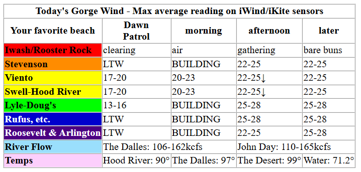
Keep in mind that this forecast attempts to predict what the iKite/iWind sensors will read. Think like a local! All sensors are not equal. Swell reads low. Viento/Arlington/The Wall read high compared to Swell. 30mph at Rufus (The Wall sensor) is about 23-24mph at Swell. 30mph at Swell is about 35-37mph at Rufus/Viento/Arlington. Hope that helps!
SHORT-TERM gorge wind forecast

Hi friends! Westerlies are forecast today, westerlies are forecast tomorrow, westerlies are forecast on Sunday… westerlies linger into Monday and Tuesday, and then model uncertainty destroys any possibility of telling you whether there will be westerlies, easterlies, or no wind at all! Saturday’s forecast will be the last one until the 17th – I’m headed to a retreat in California for a program I’m enrolled in. Not my ideal time to leave (for you or for me), but that’s what I gotta do!
Friday morning’s opening gambit was pressures of 30.06/29.96/29.94 for gradient of 0.10/0.02. Cams show complete lack of marine clouds over the metro area, which will likely lead to a midday lull between Viento and Hood River; keep that in mind as you’re planning your day. Early wind was 17-20mph between Viento and the Hatch with 10mph or less pretty much everywhere else. Models suggest westerlies will build to 22-25mph between Stevenson and Rufus by late morning.
Afternoon wind, thanks to a solid onshore temp gradient, builds to 22-25mph between Stevenson and Mosier (Hatch-Hood River will likely fall to 17-20) with 25-28mph from Rowena to Arlington. River flow over the last 24 hours was 106-162kcfs, river temp is 71.2F, and high temp forecast is 90 in Hood River and upper 90s in the desert.
GORGE PROPERTY OWNERS: PLEASE COMPLETE THIS SURVEY ABOUT WILDFIRE RISK AND PROPERTY INSURANCE FOR A HARVARD GRAD STUDENT.

RIVER FLOW FOR SITES BETWEEN AVERY (EAST OF THE DALLES) AND RUFUS: CLICK HERE FOR JOHN DAY DAM FLOW.
RIVER FLOW FOR SITES BETWEEN STEVENSON AND DOUG’S BEACH (WEST OF THE DALLES): CLICK HERE FOR THE DALLES DAM FLOW

LONGER-TERM gorge wind forecast
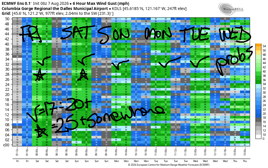
Saturday gets a bit of help from possible marine clouds west of Troutdale in the morning – this gives the desert a jump on heating. Early wind will be 20-23mph from Viento to Hood River with 7-10mph in Stevenson and east of Hood River to Arlington. Midday: 23-26mph from Stevenson to Mosier with 17-20mph from Lyle to Avery. Afternoon wind falls to gusty 19-22mph between Stevenson and Hood River and builds to 25-28mph from Mosier to Rufus with 22-25mph near Arlington. High temps: 87 in Hood River and mid 90s in the desert.
Models are struggling a bit with Sunday; it’ll be windy, but it’s unclear quite how windy it will be. For now, let’s say 20-23mph from Viento to Hood River in the morning with 22-25mph from Stevenson to Avery in the afternoon. Similar range is present in the forecast for Monday, but we’re almost certain to achieve 20mph or more. Quite a bit of range is present in Tuesday, but a bigger percentage of the ensembles are pointing at the possibility of a stronger wind. Again, 20mph or more is almost certain.
Uncertainty spikes on Wednesday and continues past Wednesday as models struggle to resolve just how warm it will get next week. So, that’s where I”ll leave you today. Let’s reconnect tomorrow and see how far into the future I can predict to set you up while I”m gone. See you on the Nch’i Wana soon!
Tip via venmo, cash or check
Want to subscribe to the email version, support Temira, and get the forecast earlier? Click on the blue box up above or use the methods below. Year-round is $29.99 or more if you think it’s worth more. Only need snow or only need wind? Warm season (May-Oct) or cold season (Nov-Apr) is $19.99 or more if you think it’s worth more. Thanks for your support!

JONES BEACH, SAUVIE ISLAND, & COAST FORECAST
Wind northerly unless otherwise indicated. For coast, it’s North/Central/South with the “central” at approximately Florence. Swell forecast from NWS for central coast. Jones: westerly unless otherwise stated. Sauvie Island: northerly unless otherwise stated.
Coast Friday: LTNW/N15/N25-30, NW swell 4′ @ 7 seconds. Saturday: 10-15/15/25-30+, NW 4′ @ 6 and W 2′ @ 11. Sunday: 15-20/20/30-35, N 4′ @ 7 and W 2′ @ 10. Jones Friday: 16-19. Saturday: 20-23. Sunday: 19-22. Sauvie Island Friday: 13-16. Saturday: 15-18. Sunday: 16-19.
BARE BONES HOOD RIVER WEATHER FORECAST
Clear sky this morning with smoke. Smoke lessens this afternoon, but could increase due to High Lava fire and will increase over night. Temps start in the upper 50s and rise to 90. Moderately strong westerlies. No rainbows. Saturday starts smoky with a few high clouds and turns clear. Temps start near 60 and rise to the upper 80s. Moderately strong westerlies. No rainbows. Sunday will be sunny. Temps start in the upper 50s and rise to the mid 80s. Moderate westerlies. No rainbows.
BIKE TRAILS INFO
NEXT WORK PARTY: August 15th and September 5th on the 133 trail in Post Canyon. Meet at Post Flats Staging Area at 9am. Hosted by Hood River County.
CLOSED TRAILS: Anything north of the 44 Road due to the Grasshopper Fire / Forest Closure Order: for example – Boulder Lakes, Gunsight, Gumjuwac, Lookout Mountain, 450, Fifteenmile. ALL GREEN MOUNTAIN LANDS: Underwood Mountain, Whoopdee Trail. Kreps lands (Hospital Hill) ARE closed as well – they usually close at the same time as Green Mountain.
TEMIRA’S AWESOME TRAVEL ADVISORY SERVICE
HYPERLOCAL WEATHER FORECAST FOR THE COLUMBIA GORGE
THE DALLES, HOOD RIVER, WHITE SALMON, TROUT LAKE, STEVENSON, CASCADE LOCKS, PARKDALE, ODELL, HUSUM, BZ, MILL A, WILLARD, GOLDENDALE, RUFUS, ARLINGTON, boardman
Good morning, neighbors! Air quality has improved for many this morning on the west side, but some areas – Parkdale, Dufur, Tygh Valley, are still pretty awful. Dear Ma Nature: cherry season is over. We’ll take rain now, please! No rain is in sight in the next couple of weeks. Instead, we have seasonable weather for the next 5 days or so and then lots of uncertainty with a general flavor of “warmer”.
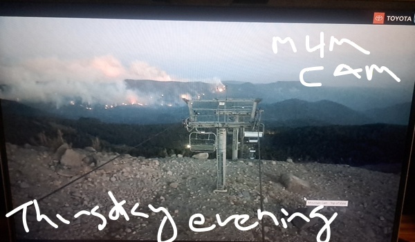
Friday morning’s weather roundup includes 45 degrees in Glenwood. In the AQI contest (ugh, there are no prizes and no joy in this one), Pine Hollow at 1376 on PurpleAir edged out Parkdale at 1354 on PurpleAir. Highway 35 remains closed this morning as firefighters conduct back-burn operations along the road that runs between Pocket Creek and Bennett Pass. If you want a view of the fire, the Mt. Hood Meadows cams are pointing right at it. Checking in with our friends around the world this morning, we see hot, muggy weather:
Bandar-e Mahshahr, Iran: 115, sunny, 16% humidity
Havana, Cuba: 83, partly cloudy 80% humidity
Muscat, Oman: 95 sunny, 58% humidity
Caracas, Venezuela: 74, partly cloudy, 80% humidity
Nuuk, Greenland: 46, cloudy, 88% humidity
Gaza City: 87, sunny, 66% humidity
Ottawa, Canada: 74, cloudy, 85% humidity
For the rest of Friday, many people will be partying because TGIF! I’ll be panic cleaning my house for the sitter who arrives Sunday. Weatherwise, we have clear sky, west wind, warmth, and yet another Red Flag Warning for extreme fire danger. You’ll not be surprised by this forecast: it’ll be warmer this afternoon than this morning! Stevenson: 88; Hood River: 90; The Dalles: 97; Pasco: 99. Wind today will be 20-25mph from Stevenson to Hood River and, eventually, 25-30mph east of Hood River to Arlington’s Triangle. We also have an increased risk of ICE storms in The Dalles today and this weekend due to the presence of a scout there two days ago.
Speaking of hot… were any of you outside yesterday in the moments when the wind switched from east to west and the humidity skyrocketed? I was. I was pruning and tying my 80 tomato plants (I HAVE NO SELF CONTROL WHEN IT COMES TO TOMATOES) when suddenly I started overheating and dripping sweat. It was bizarre!
On to Saturday… hopefully my house will be all cleaned up so I can have some fun! Hopefully it will clean itself so I don’t have to! The morning starts smoky as overnight factors contribute to the smoke settling in in the drainages around the Grasshopper and High Lava fires. Morning temps: 50-65 under clear sky. Wind will be 20mph out of the west to start between Viento and Hood River. Afternoon: 85 in Stevenson, 87 in Hood River, 94 in The Dalles, and 96 in Pasco. Westerlies build to 20-25mph between Stevenson and Hood River with 25-30mph from Mosier to Arlington.
Sunday looks slightly cooler and slightly less breezy. Morning temps will be 50-60. Afternoon: 82-92, coolest to the west, hottest in the desert. Wind will be 20-25mph between Stevenson and The Dalles. Very similar conditions are forecast Monday and Tuesday, but I won’t be here to experience them. Please enjoy them for me! Ensembles currently have a 20 degree spread in the high temp forecast for Wednesday. Generally speaking, it appears we’ll have somewhat warmer, somewhat less windy weather starting for the second half of next week, when again, I won’t be here. Hopefully the housesitter is happy with the weather! Safe travels. -TATAS
HEY! DON’T STOP READING! Is this community-focused forecast helpful to you? It sure is! It takes me a couple hours a day to write. Please join your friends and neighbors in contributing to keep it going. Venmo: @thegorgeismygym PayPal: twomirrors@gmail.com USPS: Temira / PO Box 841 / Hood River, Oregon 97031
MT HOOD SNOW FORECAST

QR codes and links for end-of-season tips – thank you!!!
Cash/check: Temira – PO BOX 841 – Hood River, Oregon 97031