


Thank you for using this forecast. Like it? Find it useful? Support it (and me!) by sending some cash my way. Why? It takes me an hour or two each morning to produce this, and it makes your life better, safer, and more fun. That’s worth something! You can get the email version sent to you. Not $99 a year. Nope. Not $49. Just $12.34 or more gets you a subscription. Click below to give financial support. Thank you!!
Credit card payments click here – – – – – – – – – Click here to use your PayPal
Venmo: @theGorgeismyGym
Snail Mail: PO Box 841, Hood River, Oregon 97031
(note: I am not a non-profit entity. The only way to accept credit cards with a user-defined amount is to use the ‘donate’ button. Thanks for understanding!)
Auto-renewing subscription. New! Awesome!
The Forecast
CoronaChat
“It’s here! We are live, with HMB 50, an Oregon not for profit to procure and donate PPE to health and public safety workers in the Gorge and beyond.
HMB 50 stands for “Hand Made Brigade, 50”. 50 is the number of hours from when Dr. Laurel Berge, called me asking for help until the time we donned (and doffed, which apparently is a real word) the first Tyvek prototype. (which was prototype 5) It’s been a quick 5 days.
It is time to redeem your pledges! If you would like to donate, to our tax deductible organization online, please do so here: http://nextdoorinc.org/donate/ Use the pull down menu to designate that the donation is being made to the Hand Made Brigade 50. If you would like your donation to be directed towards a specific area of concern (Masks, Shields or Gowns) Please note that in the comment section.
If you would like to donate via check, to our tax deductible organization, please mail the check, made out to “The Next Door” and send it to 965 Tucker Road, Hood River Oregon, 97031, with HMB50 in the memo line.
If you DON’T CARE ABOUT THE DEDUCTION, Please send a check made out to HMB50 and Mail it to 1002 Oak Street, Hood River, Oregon 97031. If you would like to venmo me, It’s @Maui-Meyer.”
| 4a-8a | 8a-12p | 12p-4p | 4p-8p | 8p-4a | |
|---|---|---|---|---|---|
| Friday 1500′->3500′ |
 |
|
|
|
|
| Saturday 3500′->4500′->3500′ |
|
|
|
|
|
| Sunday 3500′->2500′ |
|
|
|
|
|
Mt. Hood Weather Forecast
All ski areas and Nordic areas are closed at this time. Meadows is done for the season, and Timberline keeps re-evaluating when/if they will be able to open – after all, they are basically open year-round. If you’re thinking of backcountry skiing, please consider the impact you’d have on busy emergency rooms if you get injured, and also think about the impact on Search and Rescue crews.Now, if you happen to be driving over the passes, you’ll want to prepare for winter driving conditions. For Friday, there will be flurries all day with no real accumulation. The snow level will be 2000′ in the morning and will slowly rise to 3500′ overnight. Just a trace of snow falls. Wind: NW 10 early, WNW 10 in the afternoon, and SW 10 overnight.
Saturday brings another round of light snow. The snow level will be 3500′ early, 4500′ in the afternoon, and 3500′ overnight. About 0.1” water value (WV) falls during the day, for an inch of new. Another 0.15” falls overnight, for 1-1.5” of new. Wind: SW 10 early, SW 20-25 in the afternoon, and SW 10-15 overnight.
Sunday brings another round of light snow. The snow level will be 3500′ in the morning, 3000′ in the afternoon, and 2500′ overnight. About 0.1” WV falls during the day, for 1” of new. A trace falls overnight. Wind: SW 10-15 early, SW 20-30 in the afternoon, and SW 30-45 overnight. Heavier snow arrives for the 24 hour period known as Monday. AT that time, the snow level will be 2000-2500′. Travel over the passes will be impacted.
Gorge Wind Forecast
First, a public service announcement. All Oregon and Washington State Parks are closed at this time. All Port of Hood River waterfront access is closed at this time. The Army Corps has closed Roosevelt Park and John Day Dam access. They have also closed boat ramps.The wind forecast for Friday also includes showers in the west. Most places will see gusty 7-10 in the morning. East of Moiser, the wind will be gusty 13-16. In the afternoon, we’ll see the wind build to gusty 21-=24 east of The Dalles. Saturday starts with light westerlies. They slowly build to 10-13 through the whole Gorge in the afternoon. Sunday starts with light west wind. Afternoon westerlies pick up to 10-13 in the west and 20-23 from The Dalles to Threemile.
COAST, JONES, SAUVIE’S: Detailed forecast is on winter break.
Hood River Weather Forecast
It’s a cloudy morning out there, and that won’t change today. We’ll see on-and-off sprinkles all day long in the western Gorge. Temps will be in the mid 40’s early and low 50’s later. Light to moderate westerlies. 99% chance of rainbows. Saturday looks on-and-off sprinkly with rain overnight. Temps will be near 40 early and in the mid 50’s later. Light west wind. 99% chance of rainbows. Sunday looks drizzly in the morning and sprinkly in the afternoon. Temps will be in the low 40s’ early and mid 50’s later. Moderate westerlies, 99% chance of rainbows. Looking for a complete Columbia Gorge forecast? Looking for more humor in your weather? Obscenities? You’re looking for my TATAS: Temira’s Awesome Travel Advisory Service on Facebook.Cycling
All trails and sno-parks in the Mt. Hood National Forest, Gifford Pinchot National Forest, and Columbia Gorge National Scenic Area are closed. While Post Canyon may be open as of this morning, you are not allowed to park at the bottom of Post or anywhere else in the trail system. My hope is that the rest of the local trails are closed soon, as they will draw increasing crowed and spread this virus. People, if you need to ride your bike, please do so on the road where social distancing is possible.Upcoming Events – this section is on vacation due to Covid-19
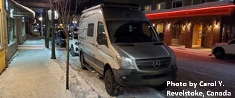
White Sprinter Van of the Week!
Click here for the White Sprinter Van map of the world!!!
Random Morning Thoughts – on break
Click here for the full events calendar.
Have an awesome day!
Temira