

MT HOOD SNOW FORECAST

Hey skiers and snowboarders! Sunny, dry, warm weather continues on Mt. Hood for the next week or so. With a strong inversion in place, lower slopes and recreation areas will be (mostly) colder than the upper slopes. Example: this morning it’s 41F at the top of Cascade (7300′) and 27F at Meadows Nordic (4500′ or so). Snow conditions are varying wildly across elevations and exposure – some areas have transitioned to granular, and some are still finishing the transition from packed powder to hardpack. The higher you go at the resorts, at least in sunny areas, the more likely it is you’ll find spring skiing conditions after the midday thaw. Morning snow: frozen hard!
Short term Mt Hood snow forecast
Friday’s weather will be sunny. The inversion cloud dissipates around Sherwood this morning per a report I got, so yes, you can escape the clouds (The Nothing) by heading up to Mt. Hood. The free air freezing level will be above 10,000′ all day today with temps rising to 40-55F depending on location. Under the inversion, pockets of sub-freezing air will remain all day. Wind: E 15 mph all day long.
Saturday looks very similar to Friday. Sunshine lingers all day long with the free air freezing level above 10,000′. Wind will be SE 15mph in the morning and light/variable in the afternoon. Temps rise to 50F as the cold pool depth drops below the Cascade crest. Sunday looks like a carbon copy of Saturday. Expect sunshine, 50 degrees for a high temp at 5000′ and light/variable wind. Ditto Monday, ditto Tuesday…
Extended Mt Hood Snow Forecast
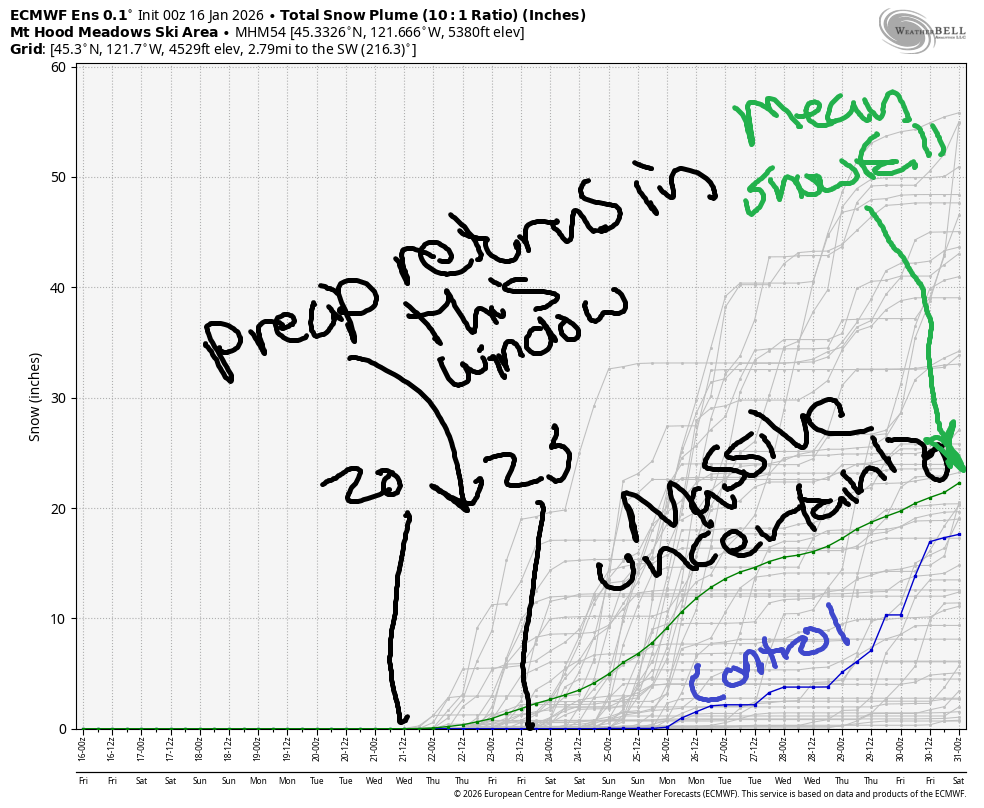
Sometime in the middle or end of next week, this pattern falls apart. Massive uncertainty exists in the timing of snowfall returning, and massive uncertainty exists in the quantity of snow we’ll receive by the end of the month.
Between the day snow returns and 1/31, the Intraquartile range (25th percentile to 75th percentile) is 7-34” of snow. Let’s vote for the upper end of that, shall we? Between now and then, make the most of the sunshine and spring skiing. I’ll see you on the snow soon!
Was that helpful? I knew it was! Guess what? All of this crucial work – from your personal wind and snow reports to the invaluable TATAS updates – is made possible by my relentless efforts. Maintaining this labor of love isn’t easy. Each daily forecast takes hours. Website hosting, weather model access, and back-end admin work takes time and money. That’s where you come in.
YOUR CONTRIBUTION MAKES A DIFFERENCE
- SUPPORT ACCURATE, HYPER-LOCAL WEATHER FORECASTING
- ENABLE ACCESS FOR ALL, EVEN THOSE WITH LESS MEANS
- SUPPORT A COOL HUMAN WHO WORKS HARD SO YOU CAN PLAY
Take a moment to click one of the buttons below. Donate $19.99 or more (how much does this forecast enhance your life?) and get the email in your inbox. Whether it’s a renewing subscription (auto-renew) or a one-time donation, every contribution makes a real difference. Help me keep this labor of love alive, so we can all continue playing, commuting, and living in the Gorge with peace of mind and the best weather forecasts possible. Thank you!


Hood River, Oregon 97031


GORGE WIND FORECAST
If you’re still seeing yesterday’s and it’s after 9am, try opening this in an incognito window
SHORT-TERM gorge wind forecast
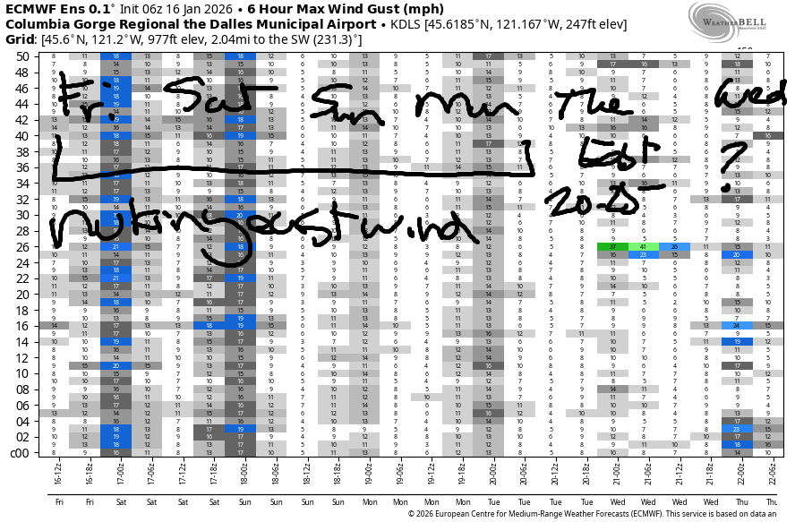
Hi friends! This is the east wind stretch you’ve been looking for (maybe). Very strong easterlies combine with above-freezing temps and all-day sunshine for conditions as good as it gets in winter. If you’re going out, dress warmly, have an emergency plan, and keep an eye on your buddies. It’s still cold out there!
Friday starts with pressures of 30.35/30.59/30.60 for strong offshore gradients. Westerlies started the day at 45-50mph at Iwash (Rooster) Rock, 40mph at Stevenson, and 20-25mph at Viento. The wind holds all day. River flow over the last 24 hours was 151-207kcfs, river temp is 42.8F, and high temp forecast is 44F with sunshine in the east wind zones.
RIVER FLOW FOR SITES BETWEEN AVERY (EAST OF THE DALLES) AND RUFUS: CLICK HERE FOR JOHN DAY DAM FLOW.
RIVER FLOW FOR SITES BETWEEN STEVENSON AND DOUG’S BEACH (WEST OF THE DALLES): CLICK HERE FOR THE DALLES DAM FLOW

LONGER-TERM gorge wind forecast
Saturday looks a lot like Friday: 45-50mph morning easterlies at Iwash with 40mph in the afternoon. Stevenson starts with 35-40mph and ends with 30mph. Viento: 20-25mph all day. High temp: 43F and sunny.
Sunday and Monday start with 40-45mph at Iwash and 30-35mph at Stevenson. The wind drops by about 5mph in the afternoon. High temps will be in the low 40s with sunshine in the east wind areas and Nothing in Hood River. Tuesday brings lesser easterlies, perhaps 25mph at Iwash with less at the other east wind launches. High temps continue in the low to mid 40s. If you manage to get out all of those days, you are impressive and will probably be hoping for a break. You’ll probably get a break in the middle of next week as this pattern starts to break down. Be safe out there!
BARE BONES HOOD RIVER WEATHER FORECAST
Nothing today. Temps will be in the upper 30s this morning and low 40s later. Light to moderate easterlies. No rainbows. Saturday will be Nothing then partly Nothing. Temps start near 30 and rise to he low 40s. Light to moderate easterlies. No rainbows. Repeated ad infinitum, but slightly colder each morning.
TEMIRA’S AWESOME TRAVEL ADVISORY SERVICE
HYPERLOCAL WEATHER FORECAST FOR THE COLUMBIA GORGE
THE DALLES, HOOD RIVER, WHITE SALMON, TROUT LAKE, STEVENSON, CASCADE LOCKS, PARKDALE, ODELL, HUSUM, BZ, MILL A, WILLARD, GOLDENDALE, RUFUS, ARLINGTON, boardman

Good morning, neighbors! What you see is what you get for weather over the next five days or so. Sunshine aloft combines with Nothing below. On some days, the Nothing partially dissipates, and on other days it won’t. Low temps will dip a little lower each day, and high temps in the lowlands will rebound to 40ish degrees. For the next five days, strong easterlies persist near Iwash (pen*s) Rock, Stevenson, and Home Valley with 10-20mph easterlies in the hills and just enough east wind to add a chill in other areas.
Speaking of chill, Glenwood was 31F this morning. This has me thinking that Glenwood may have been engulfed by the Nothing, because it should be colder. Most of the rest of us started the day in the mid to upper 30s. If you must drive through the Nothing today, be prepared for potentially frosty/icy roads and/or freezing fog. Above the Nothing, radiational cooling brings the potential for frosty roads too. The other kind of road danger, ¡CE, has not been spotted this morning.
If you’d like to voice your concerns about the behavior of ¡CE, here are some opportunities: HRVHS students are walking out today during 2nd period, around 11:30am. On 1/20, there is a national walkout at 2pm; Columbia High School Students are walking out then, and you can join this particular action in various ways. No need to be at an official protest. Take your mandated 10 minute break at that time. If you feel safe doing so, if you won’t lose your job, walk out, stop working, raise your voice. Ok. Back to the weather.
Driving to the metro area over the next several days? Expect east wind at 45-50mph near Iwash (it’s NOT a rooster) Rock. Stevenson and Cascade Locks will be positively frigid as east wind holds at 30-40mph for the next few days.
Generally speaking, everyone east of Home Valley will start each of the next five days below the Nothing. Models are notoriously bad at predicting the dissipation of the Nothing. As of this morning, models disagree on whether the Nothing will break at all today. They hold it steady all day Saturday. Some relief from the Big Gray Blanket is forecast in the afternoon on Sunday, Monday, and possibly Tuesday, but again, I stress that models struggle with this particular weather feature.
If you need sun, head east or up – the top of the Nothing was Sherwood campground on Highway 35 this morning.
You may be wondering when this pattern will end. You may be wondering when we’ll see rain or snow again. Me too! As of this morning, it seems like the pattern change will arrive at the end of next week. Say bye-bye to the ridge of high pressure and hello to… I dunno… the amount of precipitation we’ll get and the timing of that precipitation is unclear. Let’s wait for certainty together. It’s another thing we can do together to remind us that we’re all human and we all crave safety, security, love, and freedom from oppression. Safe travels. -TATAS
HEY! DON’T STOP READING! Is this community-focused forecast helpful to you? It sure is! It takes me a couple hours a day to write. Please join your friends and neighbors in contributing to keep it going. Venmo: @thegorgeismygym PayPal: twomirrors@gmail.com USPS: Temira / PO Box 841 / Hood River, Oregon 97031 You can test out the forecast subscription for a few days for free by signing up below. Easy! Do it!
JONES BEACH, SAUVIE ISLAND, & COAST FORECAST
ON WINTER VACATION UNLESS DESPERATELY NEEDED.