Meet Temira, your Gorge Forecaster

Temira (they/them) has been exploring and playing in the Gorge since 1997 – starting out as a windsurfer, then expanding into kiting (briefly!), mountain biking, winging, gravel biking, SUP foiling and even extreme gardening! With all that experience, they understand the importance of a reliable forecast. In 2009, frustrated by the lack of accurate forecasts, Temira took matters into their own hands. What began as a daily email chain between friends (Laura Green, Dave Brown, and Temira) quickly grew into a full-blown website and subscription email service.
So, why The Gorge is my Gym? Because Temira doesn’t need a traditional gym – and neither do you. The Gorge is our gym! But this blog isn’t just about Temira’s adventures; it’s about helping all of you make the most of your limited free time. Whether you’re on the snow, in the river, or on the dirt, this forecast is here to help you have fun.
Each forecast takes time – sometimes up to a couple of hours a day – and maintaining the website costs money. So do the forecast model subscriptions that provide the information underlying this forecast. If you’ve found this service helpful, consider making a contribution or signing up for the (mostly) daily email. Your support helps Temira keep bringing you the forecasts that make your adventures in the Gorge even better. It also keeps the forecasts free for folks who can’t afford to pay. Community service is important to Temira. So, pick one of the buttons below – Venmo, PayPal, or even USPS – and make a contribution. Keep this forecast going day after day! Thank you!
Mt. Hood Snow Forecast

Hi friends! Wow! What a storm this has been! We did have a period last night where temps warmed enough that snow stopped accumulating (it did mix with rain at Teacup, but it’s hard to tell what happened at T-Line without an onsite report). That said, Timberline now has a couple feet of snow on the ground, and Teacup has a foot. Timberline plans to run Pucci this weekend. Meadows: no lifts, but you know folks will be hiking to earn turns. Skibowl: not yet. Teacup? They tried, but it was too wet to groom yesterday. They plan to try again. So, now that we have all this snow on the ground, what’s next? More snow!
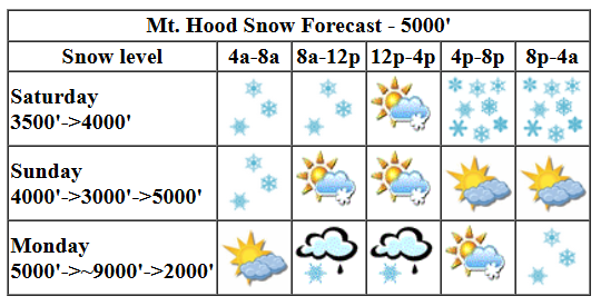
Saturday looks like another snowy one, although it’s likely there will be sunbreaks during the day. Snowfall picks up again tonight. The snow level will be 4000′ in the morning, 3500′ in the afternoon, and back to 4000′ after midnight. About 0.1” water equivalent (WE) falls during the day for an inch or two (west wind might bump up the total) of new snow. Overnight, models give us another 0.8” WE for 7-9” of new. As the wind turns to the NW tonight, snowfall rates could increase and exceed expectations. Wind: W 35 this morning, WSW 20-30 this afternoon, and NW 30 overnight.
Sunday sees the snow taper off and eventually stop. High clouds move in during the afternoon, and the sky partially clears overnight. The snow level will be 4000′ in the morning, 3000′ in the afternoon, and 5000′ after midnight. About 0.1” WE is forecast before the snow stops. That’s an inch of new. Orographics (wind/terrain effects) could add an inch or two more. Wind: NW 30-40 in the morning, NW 25-35 in the afternoon, and W 15 overnight.
Make the wah-wah noise for Monday; a (fortunately) weak and warm system moves through. This drives temps aloft over 0C. But wait… there will be cold air mixed in. This is the sort of setup that can result in freezing rain and wet snow that freezes to lifts and trees and everything. Anyway, the snow level (or should we say “freezing level” in this case?) will be 5000′ early, bouncing around up to 9000′ midday, 4000′ in the afternoon, and back to 2000′ overnight. About 0.3” WE is forecast in the mixed-precip time frame. Another 0.1” to 0.2” WE falls overnight as a couple inches of snow. Wind: What a mess! ! 15 early becomes W 60 midday and NW 45-55 overnight. If the resorts were open, there would be no lifts running.
A few more inches of snow falls on Tuesday with the snow level around 2000′. We then see a few dry days mid week. That’s followed by a return to very wet weather next weekend and into the following week. A glance at the forecast for 850mb (5000′) shows temps in the next wet period holding right around 0C, which gives us a snow level somewhere in the 4000-5000′ zone. Fingers crossed. Things look darn fine! Given all this great news, please share this forecast with your friends. Help me get the word out, and also help get the word out about my forecasts! Thank you!
Go ahead and subscribe to the forecast using the fancy auto-renew option. Don’t like electronic payment? No problem! You can send a check or cash to: Temira / PO Box 841 / Hood River, Oregon, 97031. Thank you so much for supporting the forecast. I’m glad you find it helpful, and I appreciate your kindness in supporting the work I’m doing!
Gorge Wind Forecast
Hi friends! Very active weather which includes offshore high pressure sets us up for strong, gusty, rather unpredictable westerlies. By unpredictable, I mean that it’ll be windy, but models have a lot of range. The exact strength of the wind is going to be tricky to predict.
Saturday opens up with gradients of 29.80/29.76/29.71 for gradients of 0.04 and 0.05. A system moving through this morning is followed by one approaching during the day and moving in late. Offshore: strong high pressure. This gives us a windy day! Expect gusty 13-16 or less west of Lyle. From Lyle to Boardman, we’ll see gusty 24-27 mid-morning followed by a period of 28-31 (Avery to Threemile) late morning into early afternoon. The wind drops to 24-27 mid-afternoon as the system moves inland. At this same time, areas west of Avery drop to 10-13 as drizzle arrives. Just ahead of the drizzle, you could see a short burst of stronger wind from Viento to Swell. Maybe. Head east for the best results today. River flow over the last 24 hours was 92-173kcfs (100-172kcfs at Rufus), river temp is 57.74F, and high temp forecast is 52F.
Is this feeling helpful? If so, go ahead and make a contribution using Paypal to support it. Send $19.99 or more, and I’ll send the forecast to your inbox for a year.
While the deterministic GFS isn’t all that enthusiastic about tomorrow, especially about areas east of The Dalles, the ensembles are much more optimistic. This is what I mean by “tricky to predict”. For now, let’s broad-brush it with low to mid 20s from Viento to Hood River with mid to upper 20s from Mosier to Rufus. East of there: probably less. High temp: 53F.
A truly impressive system barrels into BC on Monday and strong offshore high pressure builds in behind it. Aloft: very strong WNW wind. This timing is about 12 hours earlier than it was in previous model runs. If it holds, we should see a period of very strong (and wet) westerlies from Stevenson to Hood River and also east of The Dalles (it’s not a great setup for the Mosier-Doug’s zone). Westerlies of some sort, perhaps low 30s early and mid 20s in the afternoon, linger into Tuesday. Beyond that, we have a couple days of east wind. Whew. That’s a lot. Have fun out there!

Jones, Sauvie Island, Oregon Coast: done for the season
Alan’s Sauvie Island Wind Sensor
Very basic Hood River weather forecast. Don’t plan your life around this. You really should read Temira’s Awesome Travel Advisory Service on Facebook
Showery this morning, dry for a period midday, and rainy again later. Temps start in the upper 40s and rise to the low 50s. Moderate westerlies. 99% chance of rainbows. Sunday will be showery early then dry the rest of the day. Temps start in the low 40s and rise to the low 50s. Moderately strong westerlies. 89% chance of rainbows. Monday will be dry early, rainy midday, and then sprinkly. Temps start near 40 and rise to the low 50s. Strong westerlies. 99.99% chance of rainbows.
Link to my Local-ish Outdoorsy Events Google Calendar
Please let me know of outdoor-related local-ish events. If you don’t tell me, I don’t know!
Cycling
Please see the HRATS/Hood River County for complete details on Post Canyon closures. Newly reopened in Post: lower Trail 100 paralleling the lower part of Post Canyon Road. The Twin Tunnels Trail between Hood River and Mosier has reopened. Kreps and Green Diamond Lands have reopened. That includes Whoopdee, Hospital Hill, and Underwood. Closed: Gorge 400 and lots of other trails due to the Whisky Creek Fire. Trail near Mt. Adams due to the Williams Mine Fire. Remember that E-bikes are not allowed on USFS non-moto trails. They are allowed on moto trails.
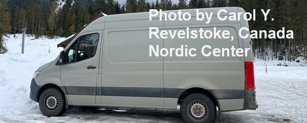
Sprinter Van of the Week!
 Click here for the Sprinter Van map of the world!!!
Have an awesome day!

