| Your favorite launch | dawn patrol |
morning max | afternoon max | executive session |
|
|---|---|---|---|---|---|
| Iwash (Rooster) Rock | morning | clouds | afternoon | buns | |
| Stevenson | 7-10 | 21-24 | 21-24 | 21-24 | |
| Viento | 17-20 | 17-20 | G20-23 | G20-23 | |
| Swell-Hood River | 17-20 | G20-23 | G24-27 | G21-24 | |
| Lyle to Doug’s | 17-20 | 20-25+ | 28-32 | 28-32 | |
| Rufus, etc: 94-159kcfs flow | 17-20 | 20-25+ | 28-32 | 28-32 | |
| Roosevelt & Arlington | 24-27 | 24-27 | 28-32 | 28-32 | |
| River flow last 24 hours: 88-159kcfskcfs | =River temp: 71.42F | HR High temp: 74F | |||
Gorge Wind Forecast
Hi friends! It’s Monday, and the marine clouds have deigned to pay us a visit. They’ll be part of the picture on and off for the next week or so. Offshore, we’ll lose the high pressure, but we’ll keep some inland heating. In other words, the westerlies are likely to stick around in some form for the long haul. Strongest days are Monday, Tuesday, and Thursday this week. I’d pick today as the best of the bunch. In other news, I talked to the Williams Mine fire folks. They’ll be scooping water either from Swift Reservoir or from the Columbia between Memaloose and Lyle. If you see them scooping near where you’re recreating, get off the river. They told me the Coast Guard will be around helping the aircraft do their job.
Is this feeling helpful? If so, go ahead and make a contribution using Paypal to support it. Send $19.99 or more, and I’ll send the forecast to your inbox for a year.
So, let’s look at today’s wind. It’s Monday, and it starts with pressures of 30.00/29.98/29.79 for gradients of 0.12/0.09. That screams “near east and Rufus” to me. Looking out the window (the good ol’ go outside look up method), there are some marine clouds past Hood River. They’ve actually pushed farther inland since I woke up. Those clouds will burn off. For best morning results, aim east of them. Generally speaking, the wind was in the 17-20 range all the way from Stevenson to Rufus early this morning with 25ish at Arlington. The wind will build to 29-32 from Lyle to Arlington late morning or early afternoon with 24-27 at Threemile. The forecast is a little more complicated to the west of Lyle. Mosier should start with 21-24 and build to 24-27. Models also suggest you’ll find 24-27 from Stevenson to Hood River once the clouds burn back. That’ll probably happen early afternoon. If it takes that long, the wind is likely to be punchy – up and down. If it happens earlier, say in the 10-11am window, the wind is likely to be steadier. Can’t tell you why. Can just tell you that’s how it goes usually. Either way, the wind will drop off to gusty 20-23ish in the evening from Stevenson to Mosier. So, to recap: once the clouds burn off, it’ll be windy pretty much everywhere. Strongest, steadiest wind will be east of Mosier, strongest from 11am on into the evening. River flow over the last 24 hours was 88-159kcfs, river temp is 71.42F, and high temp forecast is 74F for Hood River and 86F for Arlington. It’s a great day to get some Indian food at Amayah’s!
Deep marine clouds, 5000′ deep, are forecast for Tuesday morning. They’re going to stick around for a good portion of the day. This knocks down the wind in the west. Focus your attention tot he east. Models suggest the Stevenson to Mosier stretch will start with 10mph and rise to 15mph or so. East of there, the wind starts at 20-23mph from Avery to Boardman. It picks up late morning or early afternoon to 25-28 from Lyle to Arlington. We should see 27-30 in the afternoon for that stretch with 22-25 at Threemile. Remember that 27-30 on those eastern Gorge sensors is more like 20-24 at Swell. Why do I forecast for the sensors? Because historically, most people have access and are planning/driving based on those readings. High temp: 71F and cloudy for Hood River and 76F and sunny for Arlington.
Writing the complete forecast takes me 1-2 hours a day. If it saves you time, gas money, or helps you plan your life, please consider contributing.

Somewhat warmer weather all the way from the metro area to the desert on Wednesday knocks down the thermal gradients. With weak high pressure offshore, the Gorge will produce just enough, or a touch more than “just enough”. Let’s call it 16-19 from Viento to Arlington early with 18-21 from Stevenson to Mosier in the afternoon. The Rowena stretch eventually joins at 13-16 or so. High temp: 79F.
That was helpful in planning your life, wasn’t it? Go ahead and subscribe to the forecast using the fancy auto-renew option. Don’t like electronic payment? No problem! You can send a check or cash to: Temira / PO Box 841 / Hood River, Oregon, 97031. Thank you so much for supporting the forecast. I’m glad you find it helpful, and I appreciate your kindness in supporting the work I’m doing!

Extended: Ensembles have us with 26-29 on Thursday. Beyond Thursday, those ensembles definitely have cooler weather and some sort of west wind, but they’re far from a consensus about the details. They also hint at an upper level low offshore next weekend, which could really knock the wind speeds down. We’ll keep watching it to see what sort of consensus develops. Have a great day out there today!

Jones, Sauvie Island, Oregon Coast
North/Central/South coast, waves (swell forecast provided by NWS). Wind forecast for the afternoon (unless it’s a storm on the coast, in which case that’s peak wind during the day). Wind direction N (coast/Sauvie Island) and W (Jones) unless otherwise noted. Monday: LTW/LTW/N15, NW swell 4′ at 8 seconds. Tuesday: LTV/LTV/LTN, NW 3′ @ 7. Wednesday: 15/15/LTV, NW 3′ @ 10. Jones Monday: LTW. Tuesday: LTW. Wednesday: 11-14. Sauvie Island Monday: 10-13. Tuesday: LTV. Wednesday: 7-10.
Alan’s Sauvie Island Wind Sensor
Mt. Hood Weather Forecast
I’m tired. It’s on vacation.
Very basic Hood River weather forecast. Don’t plan your life around this. You really should read Temira’s Awesome Travel Advisory Service on Facebook
Mostly clear sky this morning stays mostly clear with a few high clouds. Temps start near 60 and rise to the mid 70s. Strong westerlies. No rainbows. Tuesday will be cloudy then partly cloudy. Temps start in the mid 50s and rise to 70 or so. Moderate westerlies. No rainbows. Wednesday might have a few marine clouds, but it’ll turn mostly clear. Temps start in the mid 50s and rise to 80 or so. Moderate westerlies. No rainbows.
Local-ish Events
Please let me know of outdoor-related local-ish events. If you don’t tell me, I don’t know!
There’s a weekly social for Wind Johnnies (The Gorge Wind Social) at Ferment Brewing every 3rd Monday this summer. There’s a free community paddle at Wylde Wind and Water every Saturday at 10am (gear provided, all ages). They also have a free community wingfoil orientation every Thursday at 5:30pm at the Hook (all ages, gear provided). Northwave and GoFoil sponsor wingfoil races on Tuesday evenings.
The Columbia Gorge Junior Kayak Club offers free roll sessions (gear provided) for kids at the Hood River Pool every other Tuesday from 5:30 to 7pm. Visit their website for more deets: https://www.columbiagorgejuniorkayakclub.org/. Amayah’s offers a free meal every First Thursday from 1pm to 4pm. Regular weekly events:. NK Studio’s by-donation Tuesday morning yoga class is back. Ferment’s Tuesday night 4-mile walk/run is at 6pm. There’s meditation with monks at 5:15pm (an hour) and 6:30pm (30 minutes plus a talk) at Yoga Samadhi in White Salmon. Columbia Gorge Tri Club meets at Mayer State Park at 6pm Tuesdays. At 7:15am on Wednesdays, there’s a run from the White Salmon Bakery. At 7am on Friday morning, there’s a run from Pine Street Bakery. On Fridays at 2:30pm, there’s a free meditation and stretching class at Yoga Samadhi. On Saturday at 9am, there’s a by-donation outdoor group fitness on the 2rd floor deck about Ferment Brewing.
Cycling
All vehicles on HR County forest roads need a gallon of water and a shovel. All areas to the west of 140 trail in Post Canyon are closed. Please see the HRATS for complete details, but essentially, all that is open is 7 Streams, Eldorado, 140, GP, and other trails in those areas. Mobius, Mitchell Ridge, Spaghetti, etc are all closed. People have been riding the closed trails. If this continues, all of Post will be closed. The sheriff is patrolling, and will ticket you. The Twin Tunnels Trail between Hood River and Mosier is closed due to wildfire. Kreps and Green Diamond Land (formerly SDS) are now closed to fire danger. That includes Whoopdee, Hospital Hill, and Underwood. Those lands will remain closed until significant rain in the fall. Also closed: Gorge 400 and lots of other trails due to the Whisky Creek Fire. Ape Canyon and Plains of Abraham are open per USFS website. 44 Road trails are all open and clear, including upper 450 and Fifteenmile. Gunsight is open. Boulder Lakes and other more remote trails are not bucked out yet. Remember that E-bikes are not allowed on USFS non-moto trails. They are allowed on moto trails.
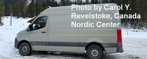
Sprinter Van of the Week!
 Click here for the Sprinter Van map of the world!!!
Have an awesome day!
