

GORGE WIND FORECAST
If you’re still seeing yesterday’s and it’s after 9am, try opening this in an incognito window
SHORT-TERM gorge wind forecast
Hi friends! Not sure what happened with the river yesterday, but the swell was fantastic in the Corridor! Maybe because the bathtub had less water in it? Flow wasn’t any lower than it’s been for weeks. Cross your fingers that the water conditions hold, because we have some good days coming up. The only day off will be Thursday and potentially Sunday. Other than that: windy day after day with some potentially big days tossed in!
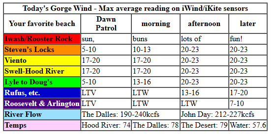
Wednesday started with pressures of 30.23/30.13/30.12 and 30.47 offshore. Morning clouds in Portland will allow the desert to get a jump on heating – a heat low is forecast for the east side. Early wind will be 17-20mph from Viento to Hood River. Everywhere else seems to be under 10mph. The wind holds at 17-20mph this morning and fills in between Stevenson and Mosier. If clouds hold longer than expected in the metro area, 20-23mph from Viento to the Hatch is within reach.
Afternoon wind, thanks to the cross-Cascade temp difference, rises to 20-23mph from Stevenson to Doug’s, drops to 17-20mph near the Hatch, and rises to 14-17mph near Avery and Rufus. River flow over the last 24 hours was 190-240kcfs, river temp is 57.6F, and high temp forecast is 74-79F, hottest out east.
RIVER FLOW FOR SITES BETWEEN AVERY (EAST OF THE DALLES) AND RUFUS: CLICK HERE FOR JOHN DAY DAM FLOW.
RIVER FLOW FOR SITES BETWEEN STEVENSON AND DOUG’S BEACH (WEST OF THE DALLES): CLICK HERE FOR THE DALLES DAM FLOW

LONGER-TERM gorge wind forecast
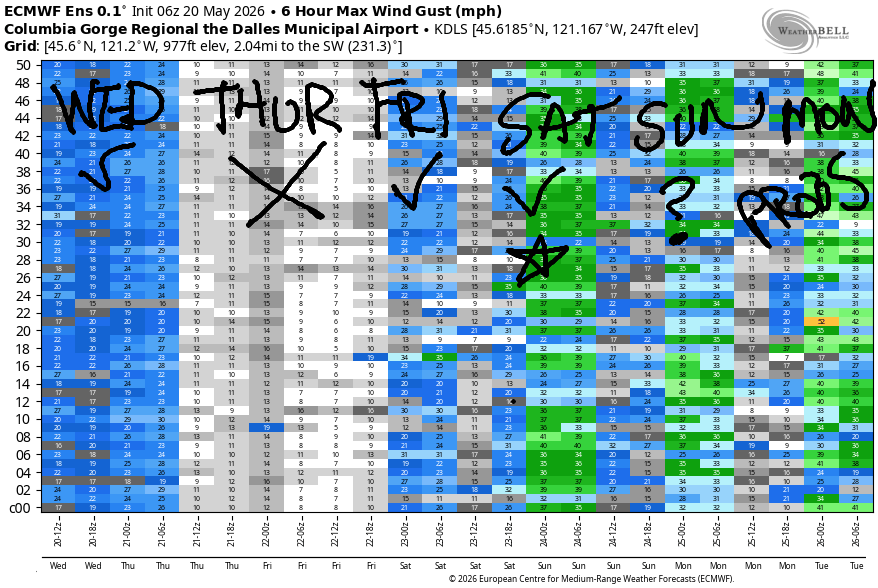
High pressure builds over the region on Thursday and leaves us with similar temps on both sides of the Cascades. Wind will be light westerly or even dead calm in the morning, which sets you up to do whatever needs doing on a no-wind day. Afternoon westerlies build to 10-13mph from Stevenson to Doug’s; it’s possible we’ll see a short period of E 10mph near Stevenson midday, but we also might not. High temp: 81-84F and mostly sunny.
The heat low shifts inland on Friday as cooler air drops south from Alaska on the west side. Models start us with 11-14mph from Stevenson to the Hatch. Afternoon wind rises to 20-23mph from Stevenson to Doug’s and 17-20mph at Rufus.
Things get more interesting on Saturday as hot weather persists in the desert, especially in central OR, cool air lingers on the Coast, and offshore high pressure persists. As of this morning, the forecast suggests 27-30mph from the Corridor to the Near East (Rowena zone) by the afternoon. This follows a low-mid 20s Dawn Patrol from Viento to Mosier. ‘Nuff said there – it’s gonna be good! An approaching front on Sunday may impact wind speed; the GFS has 16-19mph. The ECMWF ensembles are more optimistic.
Somewhere in the Monday/Tuesday time frame we have (Not Quite) The Cooldown You Were Looking For. That said, there is decent potential for big westerlies in the Monday-Wednesday time frame, which already resulted in me rescheduling my Monday appointment with my therapist to next Friday, which is far enough out that I have no idea what the weather will do. That’s all I have for you this morning. See you on the Nch’i Wana soon!

Was that helpful? I knew it was! Guess what? All of this crucial work – from your personal wind and snow reports to the invaluable TATAS updates – is made possible by my relentless efforts. Maintaining this labor of love isn’t easy. Each daily forecast takes hours. Website hosting, weather model access, and back-end admin work takes time and money. That’s where you come in.
YOUR CONTRIBUTION MAKES A DIFFERENCE
- SUPPORT ACCURATE, HYPER-LOCAL WEATHER FORECASTING
- ENABLE ACCESS FOR ALL, EVEN THOSE WITH LESS MEANS
- SUPPORT A COOL HUMAN WHO WORKS HARD SO YOU CAN PLAY
Take a moment to click one of the buttons below. Donate $19.99 or more (how much does this forecast enhance your life?) and get the email in your inbox. Whether it’s a renewing subscription (auto-renew) or a one-time donation, every contribution makes a real difference. Help me keep this labor of love alive, so we can all continue playing, commuting, and living in the Gorge with peace of mind and the best weather forecasts possible. Thank you!


Hood River, Oregon 97031


JONES BEACH, SAUVIE ISLAND, & COAST FORECAST
Wind northerly unless otherwise indicated. For coast, it’s North/Central/South with the “central” at approximately Florence. Swell forecast from NWS for central coast. Jones: westerly unless otherwise stated. Sauvie Island: northerly unless otherwise stated. Coast Wednesday: 20/20/30-35, W swell 6′ at 12 seconds. Thursday: 15-20/20-25/30-35, NW 6′ @ 11. Friday: 15/20-25/30-35+, NW 6′ @ 11. Jones Wednesday: 17-20. Thursday: 19-22. Friday: 21-24. Sauvie Island Wednesday: 13-16. Thursday: 16-19. Friday: 11-14.
BARE BONES HOOD RIVER WEATHER FORECAST
Clear this morning with some high clouds later. Temps start in the low 50s and rise to the mid 70s. Moderate westerlies. No rainbows. Thursday will be sunny. Temps start in the upper 40s and rise to the low 80s. Light westerlies. No rainbows. Friday will be sunny then partly high cloudy. Temps start in the low 50s and rise to the low 80s. Light westerlies early. Moderate to moderately strong westerlies later. No rainbows.
TEMIRA’S AWESOME TRAVEL ADVISORY SERVICE
HYPERLOCAL WEATHER FORECAST FOR THE COLUMBIA GORGE
THE DALLES, HOOD RIVER, WHITE SALMON, TROUT LAKE, STEVENSON, CASCADE LOCKS, PARKDALE, ODELL, HUSUM, BZ, MILL A, WILLARD, GOLDENDALE, RUFUS, ARLINGTON, boardman
Good morning, neighbors! Lovely spring weather continues this week with sunshine and west wind. I mean, duh, it’s the Gorge. Of course it’s windy. Warmth persists through Sunday or Monday, and then we’ll see a chance of some rain. At the 50th percentile, the ECMWF ensemble gives us about 0.5” for the Cascades and less than 0.10” for areas east of The Dalles. During that period of moisture, the snow level will drop as low as 4000′ (Mon/Tue) and then rebound as next week progresses. Looking at the next couple of weeks, uncertainty is high, but there’s no sign of a significant heat wave. So far this spring is being pretty darn awesome!
Glenwood and Tehran this morning & today’s Gorge weather forecast
Looking around the Gorge and world this morning, we have 34F in Glenwood and no sign of !CE on the roads. Forecast for Tehran, Iran today is 72 degrees and partly cloudy sky. Most of us will be warmer than central Iran – temps rise to SIX-SEVEN in Cascade Locks, 74 in Hood River, and 78-79F from The Dalles eastward. West wind will be 20-25mph today as far east as Wishram or perhaps Rufus late in the day.
Thursday’s Gorge weather forecast
A few low clouds start Thursday west of Hood River with clear sky everywhere else. Temps will be 40-50F to start the day except in Glenwood, where it’ll be 35ish. If you need a light wind period, Thursday morning is your bet – we might even see a period of dead calm wind from 8am on into early afternoon. Westerlies eventually rise to 10mph from Stevenson to The Dalles. Temps max out in the mid 70s to the west, 80F near Hood River, and 85F in the The Dalles with 80F out near Pasco.
Extended Gorge weather forecast
Friday looks mostly sunny all day long with just enough high clouds in the evening to make a pretty sunset. Morning temps will be 42-52F. Afternoon: 75-87F, hottest in The Dalles. West wind will be 10-15mph between Stevenson and Hood River early with 20-25mph from Stevenson to Rufus in the afternoon. Temps stay warm on Saturday – 72-88F, hottest in the desert – and westerlies pick up to 30mph, strongest near Hood River.
As we move into the deeper future, Sunday onward, uncertainty rises. It does appear we’ll see cooler temps and a bit of rain starting Monday and continuing into Tuesday. Temps probably bottom out on Tuesday (snow level 4000′, highs low 60s) before slowly climbing again into the end of next week. As I mentioned earlier, there’s zero sign of an early season heat wave (90+) in the next couple of weeks. Yay. Safe travels. -TATAS
HEY! DON’T STOP READING! Is this community-focused forecast helpful to you? It sure is! It takes me a couple hours a day to write. Please join your friends and neighbors in contributing to keep it going. Venmo: @thegorgeismygym PayPal: twomirrors@gmail.com USPS: Temira / PO Box 841 / Hood River, Oregon 97031 You can test out the forecast subscription for a few days for free by signing up below. Easy! Do it!
MT HOOD SNOW FORECAST

QR codes and links for end-of-season tips – thank you!!!
Cash/check: Temira – PO BOX 841 – Hood River, Oregon 97031


