


Thank you for using this forecast. I offer it freely so you can have more fun and plan your life. It does take significant time and energy to produce. If you find yourself using it often, or if you feel your life is more awesome because of my work, please make a donation. You can get this forecast via email by donation. The email subscription isn’t $99/year. Not $50/year. Donating $12.34 or more gets you on the list for 12 months. Thank you for your support and thank you for trusting my forecast.
Click here to donate using a credit card.
Click here to donate via PayPal.
Venmo: @theGorgeismyGym
Snail Mail: PO Box 841, Hood River, Oregon 97031
Get the email version free through the end of January – try it out! Click here.
| 4a-8a | 8a-12p | 12p-4p | 4p-8p | 8p-4a | |
|---|---|---|---|---|---|
| Wednesday 10,000′ |
 |
|
|
|
|
| Thursday 10,000′->2000′ |
 |
|
|
 |
 |
| Friday 2000′ |
 |
|
|
|
|
Mt. Hood Weather Forecast
Warm and dry and sunny weather on Wednesday gives way to a more active weather pattern starting Thursday night. The “activity” may or may not continue through the weekend, as models disagree on the extent of precipitation for Saturday and Sunday.
For Wednesday, the mountain will be sunny and warm. Free air freezing level 10,000′. Wind: SW 10 early, WSW 20 in the afternoon, and W 30 overnight.
Thursday looks partly cloudy during the day with mixed precip, rain, or wet snow that switches to snow overnight. Precip starts around 10pm with the snow level around 5500-6000′. By 1am, the snow level will be down to 2000′. Overnight, the mountain will see about 0.6” water value (WV). Let’s call that 0.2” of rain or mixed precip followed by 0.4” WV that falls as 3-5” of new snow. Wind will be W 30 early, SW 25 in the afternoon, SW 35 overnight, and WSW 35 after midnight. The warm temps early followed by the crash in temps could result in icing on lifts.
Friday looks snowy during the day with partly cloudy condition overnight. The snow level will be 2000′ early, 2500′ in the afternoon, and 2000′ overnight. About 0.3” WV falls during the day, for 3-4” of fresh powder. No snow overnight. Wind will be WNW 35 early, WSW 20 in the afternoon, and S 10 after midnight.
As I said before, models disagree on the amount of precipitation for the weekend. They also disagree on the amount of sunshine. Combing and averaging gives us light snowfall over the weekend for an inch or two of new snow each day, but that’s far from an accurate forecast. Models do seem to agree on a more intense system on Monday, but this one looks a bit warm for your average rider’s taste.
Gorge Wind Forecast
For Wednesday, we’ll have easterlies at 15-20 or so for the first half of the day. The wind turns calm in the afternoon. Thursday starts off with light east wind and switches to light west flow with calm wind in the central Gorge after noon. Friday looks calm early. In the afternoon, the wind will pick up to light westerly in most places with gusty 15-18 from The Dalles to Arlington.
JONES, SAUVIE’S, COAST: now on vacation for the fall and winter. Will return in spring.
Virtual Spin – video, beats, friends, BIKES!!
Got a schedule that makes it hard to link up with scheduled classes? No worries, we got you. Our virtual spin program gives you access to our all new Spin Studio built for our Cycling program. Connect up with Virtual Classes led by a live coach, or with voiceover some fresh beats and paired with Scenic Rides all over the world. You can even hit one button and play your favorites from NetFlix and a variety of other media services. Or jam out to tunes and catch up with your friends for an all-time great experience in a private studio. Bike Max is 10 people. Meet up with your friends on your schedule and keep your cycling fitness strong all winter long!Get signed up now by clicking here!
Gorge Weather Forecast
Wednesday is starting off clear and will stay that way. Temps will be in the upper 20’s early and near 40 in the afternoon. East wind. No rainbows. Thursday looks partly to mostly high overcast and then turns rainy late. Temps will be in the low to mid 30’s early and mid 40’s in the afternoon. East wind turns calm in the afternoon. No rainbows. Friday looks rainy early and showery with partly cloudy sky for the rest of the day. Temps will be near 40 early and in the upper 40’s later. Light west wind. 99% chance of rainbows.
For weather specifically directed at travel through the Gorge, please visit Temira’s Awesome Travel Advisory Service on Facebook.
White Sprinter Van of the Week!
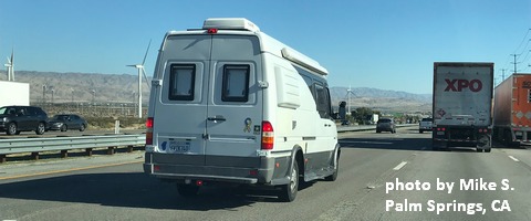
Click here for the White Sprinter Van map of the world!!!
Road and Mountain Biking
*FREEZE THAW ALERT* We’re in a pattern of overnight freezing temps with daytime temps above freezing. This means the soil structure on the trails will liquefy. If you ride them, you will do major damage. Please don’t. Or, if you must ride, only do so under the forest canopy where the trails will not thaw. Or ride your road bike, gravel roads, or the trainer!
Upcoming Events
It’s Wednesday, and the only thing on the events calendar today is free yoga at the FISH food bank in Hood River at 10am.
Random Morning Thoughts
Click here for the full events calendar.
Have an awesome day today!
Temira
