

MT HOOD WEATHER FORECAST
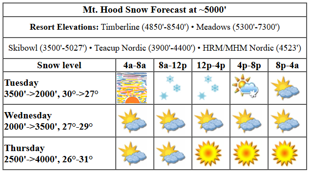
Hey skiers and snowboarders! Today, Tuesday, is your best shot at fresh snow this week. After that, Mt Hood weather looks dry, or mostly so, until next Monday or Tuesday. Powder hounds should be happy with the Mt Hood forecast beyond that: colder temps and lots of snow for up to a week. Ensembles have anywhere from 2” to 6.5” of water equivalent (two to six and a half feet of snow, potentially) for that week-long period, and those same models keep temps well below freezing at 5000′ for that time period. Fingers crossed this forecast stays just like it is right now! Let’s get back to today: snow conditions currently are frozen and loose granular, but they’ll add some fresh, moderately dense snow as the day goes on.
After a beautiful sunrise, clouds quickly build. Snow starts up mid-morning and continues into the afternoon. The snow level will be 3500′ this morning, 2500′ this afternoon, and the freezing level will drop to 2000′ tonight. Temps at 5000′ start around 30F and fall to the mid 20s. About 0.2” water equivalent (WE) is forecast today for a couple inches of new snow before 4pm. After 4pm, there’s just a trace in the forecast before the sky clears for a few hours and then clouds over. Wind: SSW 10-15 early, WSW 30-35 this afternoon, WSW 20-25 this evening, and E 10 after midnight.
High clouds Wednesday morning give way to at least some sunshine in the afternoon. No precip is expected. The free air freezing level will be 2000′ in the morning, 3500′ in the afternoon, and 2500′ after midnight. Temps bounce around in the mid to upper 20s. Wind: W 10 in the morning, E 10 in the afternoon, and light northerly after midnight.
If you’re seeing sunshine, try Thursday. It looks partly cloudy to start and sunny by the afternoon with a few little fluffy clouds from instability as a low moves into Idaho. The free air freezing level will be 2500′ in the morning, 4000′ in the afternoon, and 3500′ after midnight. Temps start in the mid 20s and rise to the low 30s. Wind: Light and variable all day peaking at NW 10-15 in the afternoon. Sunshine is forecast all day Friday with temps in the low 30s. As of this morning, the weekend looks dry with intermittent high clouds, plenty of sun, and a freezing level of around 5500′ with max temps in the low to mid 30s. Next week: as I mentioned before, somewhere in that Monday-Tuesday time frame, the big weather picture transitions to cold, wet, and snowy. Yes! See you on the snow!
Was that helpful? I knew it was! Guess what? All of this crucial work – from your personal wind and snow reports to the invaluable TATAS updates – is made possible by my relentless efforts. Maintaining this labor of love isn’t easy. Each daily forecast takes hours. Website hosting, weather model access, and back-end admin work takes time and money. That’s where you come in.
YOUR CONTRIBUTION MAKES A DIFFERENCE
- SUPPORT ACCURATE, HYPER-LOCAL WEATHER FORECASTING
- ENABLE ACCESS FOR ALL, EVEN THOSE WITH LESS MEANS
- SUPPORT A COOL HUMAN WHO WORKS HARD SO YOU CAN PLAY
Take a moment to click one of the buttons below. Donate $19.99 or more (how much does this forecast enhance your life?) and get the email in your inbox. Whether it’s a renewing subscription (auto-renew) or a one-time donation, every contribution makes a real difference. Help me keep this labor of love alive, so we can all continue playing, commuting, and living in the Gorge with peace of mind and the best weather forecasts possible. Thank you!


Hood River, Oregon 97031


GORGE WIND FORECAST

Hi friends! Nice seeing all of you on the river yesterday. Maybe someone put out a memo, because there were quite a few more people than there have been lately despite the river temp still being right around 40 degrees. The next best chance for enough west wind to get you on the river is Thursday with a somewhat lesser chance on Friday. Tuesday kicks off with light offshore gradient, but the wind will turn light westerly this afternoon. After 2pm, you’ll find W 11-14 from Iwash to Viento or maybe to Swell, light wind from Hood River to Doug’s, and gusty 18-22 from Avery to Rufus. Arlington joins after 4pm with 13-16. River flow over the last 24 hours was 97-157kcfs, river temp is 40.28F, and high temp forecast is 50F with drizzle through early afternoon as far east as Boardman.
Not much happens Wednesday. The day starts nearly calm. Easterlies pick up to 10mph at Iwash (Rooster) Rock and 10-15mph at Stevenson before dropping to 10mph at both locations after 1pm. High temp: 52F and mostly clear. Models currently call for west wind on Thursday afternoon as a low move along the OR-CA border and into Idaho. As of this morning, models suggest 15-18 from Stevenson to Mosier, light wind in the Lyle stretch, and 20-23 from Avery to Arlington. Lingering westerlies are possible near the Hatch on Friday morning. Weekend: not much in the cards in any of the ensemble members. Have a great day today, everyone!
BARE BONES HOOD RIVER WEATHER FORECAST
Mostly cloudy sky this morning adds rain that sticks around to mid-afternoon. Temps start near 40 and rises to 50 or so. Calm wind early. Light to moderate westerlies later. 99% chance of rainbows. Wednesday starts partly cloudy and turns clear. Temps start in the mid 30s and rise to the low 50s. Light easterlies. No rainbows. Thursday will be mostly clear with partly Nothing then clear. Temps start in the mid 30s and rise to the mid 50s. Moderate westerlies. No rainbows.
TEMIRA’S AWESOME TRAVEL ADVISORY SERVICE
HYPERLOCAL WEATHER FORECAST FOR THE COLUMBIA GORGE
THE DALLES, HOOD RIVER, WHITE SALMON, TROUT LAKE, STEVENSON, CASCADE LOCKS, PARKDALE, ODELL, HUSUM, BZ, MILL A, WILLARD, GOLDENDALE, RUFUS, ARLINGTON, boardman
Good morning, neighbors! Other than today, the weather’s looking pretty chill (chill meaning “mellow”, not chill meaning “cold”) through the weekend. Not much rain, plenty of sun, high temps 50+, limited frost… No snow, no ice… Looking deeper into the future… colder, wetter weather returns in the early part of next week. Some of the higher-elevation communities will likely see snow, but it’s too early to sort out the details.
Let’s start the day by checking in with Glenwood: they bottomed out at 29 degrees last night and are currently sitting at 32 degrees with a dewpoint of 27. If the darn rain would hurry up and arrive, Glenwood could see some snow or ice. But the rain is taking its sweet time, and so it’ll probably just be rain. TATAS Executive Order Of The Day: wait, when all parties don’t follow the laws or choose to subvert the laws to achieve their personal desires, laws and legislation and checks and balances no longer work. This is called “anarchy”, and we are currently experiencing it. I’m not sure how you address anarchy with executive orders or laws. Frightened by this? You should be.
tuesday
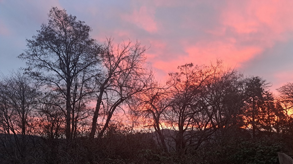
Tuesday’s weather started off with a beautiful (in my opinion, anyway), sunrise. Although… all sunrises are beautiful in their own ways, and the beauty of them allows us to tap into the wonder and joy that is always present under the day-to-day bullshit of our lives. So, today’s cloudy, and it’ll turn drizzly. Heaviest rain should be mid to late morning. West of Hood River, you’ll find moderate rain, enough to make the commute to the metro area unpleasant-but-not-terrifying. Drizzle (or sprinkly weather) extends all the way to Boardman this afternoon. From 4pm, on, the only place you’ll find rain will be west of Cascade Locks. High temps along the river today will be right around 50F. Wind starts calm. It’s currently completely mirror-like in front of my house in Hood River. Afternoon westerlies pick up to 10-15mph from Iwash (willie) Rock to Viento, 10mph near Hood River and Lyle, and 15-25mph from Avery to Amayah’s Indian Curry and Kababs, the location formerly known as Biggs Junction.
wednesday
Partly cloudy sky tonight and calm wind allows our usual cold spots (Parkdale, Glenwood, Centerville, east side of The Dalles) to drop a bit below freezing Wednesday morning. The rest of us will start Wednesday in the mid 30s. By afternoon, it’ll be full-on sunshine and 52.3F (I initially typo-ed 523F, but I didn’t want to scare you, so I added the decimal point) with very light east wind.
thursday
A low pressure system transits inland to Idaho along the OR-CA border Thursday. Despite that excitement happening to the south of us, we’ll be dry and mostly sunny. Afternoon instability related to this system forms some little fluffy clouds. Onshore gradients build as that low moves inland, and westerlies pick up to 15-25mph all through the Gorge. We can refine that wind forecast later, or you can just read the Wind Johnnie forecast for a more detailed wind forecast.
all those days after thursday
Friday, Saturday, and probably Sunday will be dry and 55-60 degrees. Monday’s most likely a transition day. Beyond that, we’re in for a week or so of cooler, wetter weather. It’s very unlikely we’ll see snow on the 84/14 commuter corridor, but it’s quite possible that our friends in the elevated communities (maybe that’s you!) will pick up some snow next week. We shall see. Safe travels. -TATAS
HEY! DON’T STOP READING! Is this community-focused forecast helpful to you? It sure is! It takes me a couple hours a day to write. Please join your friends and neighbors in contributing to keep it going. Venmo: @thegorgeismygym PayPal: twomirrors@gmail.com USPS: Temira / PO Box 841 / Hood River, Oregon 97031 You can test out the forecast subscription for a few days for free by clicking this link: https://subscribepage.io/YhevGc
