

MT HOOD SNOW FORECAST

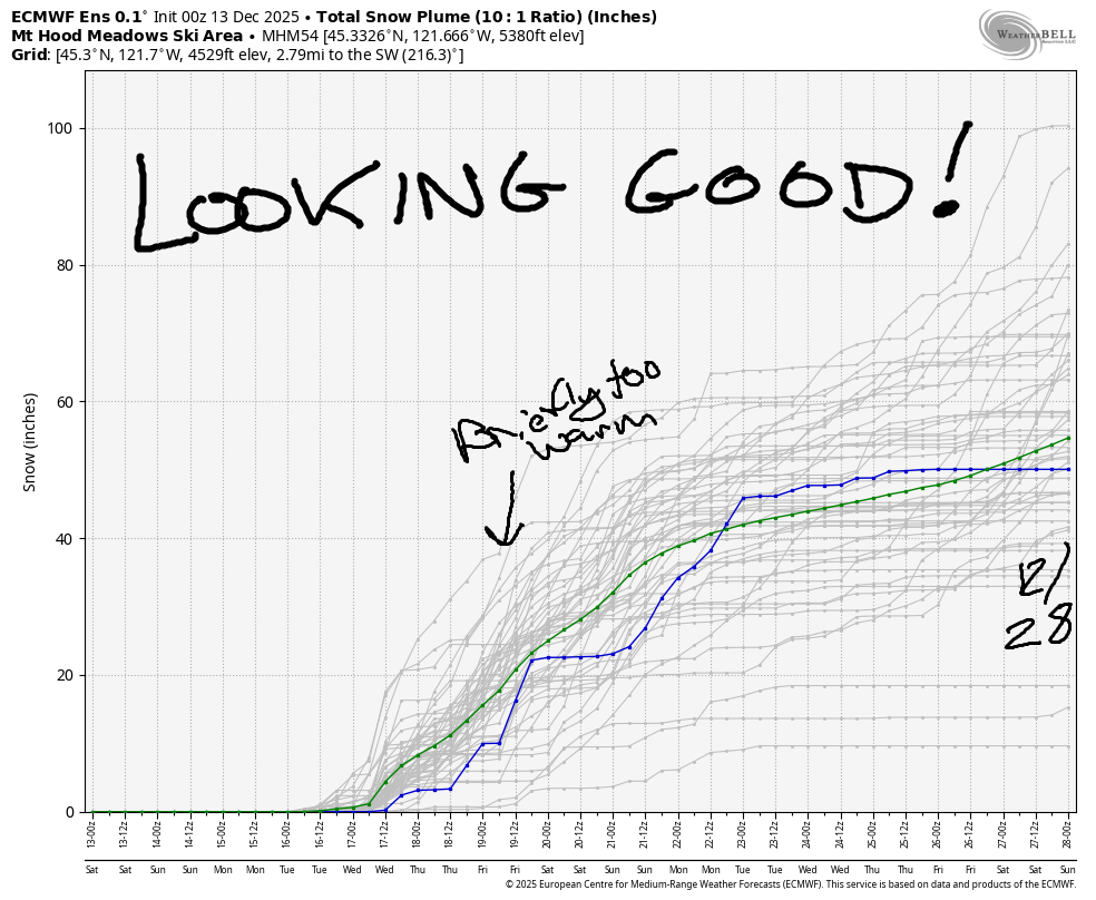
Hey skiers and snowboarders! Things, and by things I mean the amount of snow in the forecast, are really looking up. All of the GFS ensemble members and 78% of the Euro give us enough snowfall for a potential start to ski season by next weekend or early the following week. Once it starts snowing, it’s likely to stay snow through at least the 28th of December, with just a short exception of mixed precip/rain/icing sometime next Thursday. Now that we’re all stoked, let’s dive in, and don’t get discouraged by the next few days – we’re stoked on the long-term here!
Saturday will be sunny on Mt. Hood. The free air freezing level will be around 12,000′ for the 24 hour period. Wind: W 15 this morning, SW 10-15 in the afternoon, and SW 20-35overnight. Sunday will be cloudy with a trace of rain. The snow level will be 12,000′ in the morning and 9500′ from late afternoon into the night. Wind: SW 20-35mph all day and all night. Rain continues on Monday with the snow level around 9500′ during the day time and 6000′ after midnight. About an inch of rain is currently forecast. Wind: SW 20-35mph in the morning, WSW 40-55mph in the afternoon (which could drive up rainfall beyond that 1.0”), and SW 25-40 after midnight.
Mixed precip is in the cards Tuesday daytime as the snow level hangs around 6000′ in the morning, bounces to 7000′ in the afternoon, and then (HOORAY), falls to 3000-3500′ after midnight. About 0.8” mixed precip is forecast during the day. Models give us about 0.8” water equivalent (WE) as mixed precip, then snow overnight. Given the BLASTING west wind overnight, snow totals are likely to over-perform dramatically. For now, let’s call it 8-12” at 5000′. Wind: SW 30-50 during the day, and W 60-65 overnight.
On Wednesday into Thursday, the snow level hovers around 2500-3000′ (yay, Skibowl!) with strong WNW then WSW wind. About 0.8” WE is forecast. With orographic enhancement, we’re looking at 8-11” new snow. Another 1.5” (at least) WE is forecast in the Thursday-Friday time period. At some point on Thursday, temps spike and the precip type switches to rain/mixed for several hours.
It’s worth noting that 21% of the Euro members do bring that Thursday system in as a full-on Pineapple Express. It’s an unlikely scenario, but worth holding lightly. 100% of the GFS keeps us (mostly) cold enough, and 78% of the Euro does as well. Beyond that: plenty cold for snow at Timberline and Meadows, and probably plenty cold enough for Skibowl too. Barring the outlier Thursday scenario, ski season is coming very soon!
Was that helpful? I knew it was! Guess what? All of this crucial work – from your personal wind and snow reports to the invaluable TATAS updates – is made possible by my relentless efforts. Maintaining this labor of love isn’t easy. Each daily forecast takes hours. Website hosting, weather model access, and back-end admin work takes time and money. That’s where you come in.
YOUR CONTRIBUTION MAKES A DIFFERENCE
- SUPPORT ACCURATE, HYPER-LOCAL WEATHER FORECASTING
- ENABLE ACCESS FOR ALL, EVEN THOSE WITH LESS MEANS
- SUPPORT A COOL HUMAN WHO WORKS HARD SO YOU CAN PLAY
Take a moment to click one of the buttons below. Donate $19.99 or more (how much does this forecast enhance your life?) and get the email in your inbox. Whether it’s a renewing subscription (auto-renew) or a one-time donation, every contribution makes a real difference. Help me keep this labor of love alive, so we can all continue playing, commuting, and living in the Gorge with peace of mind and the best weather forecasts possible. Thank you!


Hood River, Oregon 97031


GORGE WIND FORECAST
If you’re still seeing yesterday’s and it’s after 9am, try opening this in an incognito window
today’s gorge wind forecast
Hi friends! Not much happening in the next couple of days, but depending on timing and setup, we could see westerlies Monday through Wednesday. A period of strong wind is almost certainly in the cards as a strong cold front arrives in the late Tuesday to early Wednesday window. Cross your fingers that the timing is during the day, not overnight!
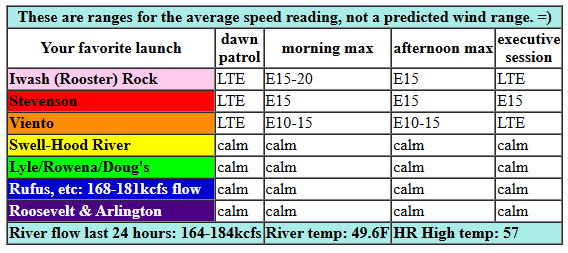
Saturday starts nearly calm, but easterlies pick up mid-morning. We’ll see a few hours of 20mph or so at Iwash (Rooster) Rock before the wind drops below 10mph there in the afternoon. Stevenson climbs to 15mph, maybe a few mph more, and holds into the afternoon. River flow over the last 24 hours was 164-184kcfs, river temp is 49.6F, and high temp forecast is 57F with sunshine! Watch for debris in the river from recent heavy rains.
RIVER FLOW FOR SITES BETWEEN AVERY (EAST OF THE DALLES) AND RUFUS: CLICK HERE FOR JOHN DAY DAM FLOW.
RIVER FLOW FOR SITES BETWEEN STEVENSON AND DOUG’S BEACH (WEST OF THE DALLES): CLICK HERE FOR THE DALLES DAM FLOW

tomorrow’s gorge wind forecast
Sunday starts light westerly. We could see 11-14mph from Stevenson to Viento in the afternoon, but that’s about it. High temp: 55F and cloudy.
extended Gorge wind forecast
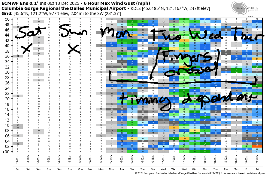
A rainy system arrives on Monday. Models have a wide range of possible wind speed. Most likely scenario is upper teens west of Hood River and east of Rufus (lighter in between), but more is possible. Light westerlies persist on Tuesday ahead of the next, much stronger, system.
When this one swings through, we’ll have a period of very strong west wind. As of right now, it looks like that will happen late Tuesday night or early Wednesday morning with lingering moderately strong westerlies for much of Wednesday. Fingers crossed. With this cold front swinging through, high temps on Wednesday are forecast to fall into the mid 40s, so be prepared! Beyond that… we’re probably looking at the start of ski season, but this wind forecast shall still be here for you!
BARE BONES HOOD RIVER WEATHER FORECAST
Mostly clear most of today with some high clouds later. Temps start in the low 40s and rise to the upper 50s. Light easterlies. No rainbows. Sunday start with high clouds and becomes cloudier. Temps start in the low 40s and rise to the mid 50s. Light westerlies. No rainbows. Monday will be rainy, heaviest in the morning. Temps start in the mid 40s and rise to the upper 50s. Moderate westerlies. 99% chance of rainbows.
TEMIRA’S AWESOME TRAVEL ADVISORY SERVICE
HYPERLOCAL WEATHER FORECAST FOR THE COLUMBIA GORGE
THE DALLES, HOOD RIVER, WHITE SALMON, TROUT LAKE, STEVENSON, CASCADE LOCKS, PARKDALE, ODELL, HUSUM, BZ, MILL A, WILLARD, GOLDENDALE, RUFUS, ARLINGTON, boardman
Good morning, neighbors! It’s a dark and gloomy morning underneath the Nothing along the banks of the Nch’i Wana. Out around the region, as best we can tell so far, the roads are free of ¡CE. Coming up in a week or so, our higher-elevation roads could be seeing some snow and ice, but that’s far from certain. Almost certain is a fair bit of rain in the upcoming week. But before we get to that: two more days of dry, unseasonably warm weather here in the Gorge.
Looking around the region this morning, we have my usual source refusing to give me a temp for Glenwood. Let’s substitute Goldendale because they have some of the same letters. Morning low: 37 degrees there. Compare and contrast with 53F on Middle Mountain and 85F (max 100F) at the Coldwater Ridge Visitor’s Center, where the thermometer is (hopefully) broken, and if it’s not broken, we should all make a field trip for one last taste of summer.
For the rest of today (it’s Saturday), we should see the Nothing break up and clear sky return for all of us. Late in the day, high clouds move in from the west. If they stay thin enough, a colorful sunset is assured. High temps rise to the mid-upper 50s as far east as The Dalles with low-mid 50s out in the desert. East wind rises to 15-20mph in the usual spots (Cock Rock and Cascade Cocks, I mean Locks).
Overnight into Sunday, high clouds swarm the Gorge sky. We wake to temps in the low 40s and a few hours of drizzle for areas west of Underwood. Clouds thicken like Santa’s cock when you touch it, but thanks to a warm air mass, temps rise to the mid 50s. SO WARM FOR DECEMBER! Normal high temp: 42F. We’ll have light west wind early and west wind at 10-15mph west of Mosier in the afternoon.
Our next atmospheric river arrives on Monday with moderate to heavy morning rain from Stevenson to Hood River and light rain to the Arlington Triangle. Rain persists all day west of Hood River, and it will be strong enough to make your drive to/from The City unpleasant. West wind in the teens to low 20s ensures that the pineapple-flavored air makes it inland – high temps will be 58-60F. That’s record territory. Speaking of… we did set both a record high-low and a record high-high on Friday.
Tuesday daytime brings rain to the far western Gorge. In the evening, the next atmospheric river strikes. Overnight, temps aloft plummet. This results in a period of heavy rain and potentially very strong west wind both at river level and up in the hills. Up on the mountain passes, we’ll see a full-on blizzard as moderately heavy snowfall combines with 60mph west wind and a snow level that bottoms out around 2000-2500′. That means some of you could pick up a little snow, but significant accumulations in the TATAS forecast area currently seem unlikely.
Lowland rain and strong wind continue (details later) into Wednesday, and then we have the potential for another very strong system Thursday into Friday. In other words, it’s going to be a very active weather week with messy driving conditions possible in both the western Gorge and mountain passes. So you better make the most of the nice weather this weekend! And this Nothing cloud better hurry the F up and burn off. Safe travels. -TATAS
HEY! DON’T STOP READING! Is this community-focused forecast helpful to you? It sure is! It takes me a couple hours a day to write. Please join your friends and neighbors in contributing to keep it going. Venmo: @thegorgeismygym PayPal: twomirrors@gmail.com USPS: Temira / PO Box 841 / Hood River, Oregon 97031 You can test out the forecast subscription for a few days for free by signing up below. Easy! Do it!
JONES BEACH, SAUVIE ISLAND, & COAST FORECAST
ON WINTER VACATION UNLESS DESPERATELY NEEDED.
Leave a Reply