


Thank you for using this forecast. I offer it freely so you can have more fun and plan your life. It does take significant time and energy to produce. If you find yourself using it often, or if you feel your life is more awesome because of my work, please make a donation. You can get this forecast via email by donation. The email subscription isn’t $99/year. Not $50/year. Donating $12.34 or more gets you on the list for 12 months. Thank you for your support and thank you for trusting my forecast.
Click here to donate using a credit card.
Click here to donate via PayPal.
Venmo: @theGorgeismyGym
Snail Mail: PO Box 841, Hood River, Oregon 97031
Get the email version free through the end of November – try it out! Click here.
| 4a-8a | 8a-12p | 12p-4p | 4p-8p | 8p-4a | |
|---|---|---|---|---|---|
| Tuesday 10,000′->7000′ |
 |
|
|
|
 |
| Wednesday 7000′->4500′ |
 |
|
|
 |
 |
| Thursday 4500′->5000′->3500′ |
|
 |
|
|
|
Mt. Hood Weather Forecast
There’s finally enough snow in the forecasts for the Timberline and Meadows to jump for joy! Models are coming into agreement on a couple feet of new snow over the next few days. Hooray!
For Tuesday, the weather will be clear on Mt. Hood with clouds overnight. Free air freezing level: 10,000′ falling to 7000′ overnight. Wind: S 10 slowly building to SSW 30.
Wednesday starts off with rain and switches to snow overnight. Snow level: 7000′ in the morning, 5000′ after sunset, 4500′ after midnight. About .2” water value (WV) falls as rain during the day. Another .1-.2” WV falls as snow overnight, for up to an inch of wet accumulation. Wind: SSW 35-40 until midnight, then WSW 25.
Thursday starts off with flurries and becomes very, very snowy. Snow level: 4500′ early, 5000′ daytime, 3500′ evening and overnight. About 1.0” WV falls between 10am and 4pm, for 8-10” of dense base-building snow. Another .3-.5” falls overnight, for 3-5” of fluffier snow. Wind: WSW 25 daytime, W 35-40 overnight. The overnight wind could enhance snowfall by 50%.
Friday also looks snowy, and Skibowl will be happy with this day: Snow level 3500′ early, 2500′ afternoon and evening. About 1.0” WV falls during the day, for 9-11” at the higher resorts. Another .4” WV falls overnight, for 5-6” up high and 3-4” down low (on the passes too – careful!). Wind: W 35 in the morning, WNW 40 in the afternoon and evening. That wind strength and direction could increase snowfall by 50-100%. That’s all lovely news for base building. Sadly, a wee bit of rain looks to fall on Sunday morning, just 0.1” or so, enough to put a crust on all the powder. But whatevs… we’ll finally have snow!
Gorge Wind Forecast
Happy Tuesday. Let’s keep this quick: we’ll have east wind at 45-50 near Rooster Rock, 30-35 near Stevenson, and 20-25 near Viento Tuesday and Wednesday. Thursday starts off with light and variable wind. In the afternoon, we’ll have W 15-20 in the far western reaches, calm wind from Stevenson to The Dalles (perhaps to Biggs), and gusty 20-30 in the far eastern reaches of the Gorge late in the day. Friday starts off with light westerlies. Late in the day, perhaps too late to do anything with it, the wind will pick up to relatively steady 25-28. Tuesday flow: 88,200cfs. Temp: 50 degrees.
JONES, SAUVIE’S, COAST: now on vacation for the fall and winter. Will return in spring.
Power Station cycling classes start November 5th and run all winter!!
It’s that time of year: you’re in peak cycling fitness, and now the rain is falling. You’re dreading losing everything you’ve gained over the dry months. Want to keep that fitness this winter and also build some strength? Get signed up now for Power Station winter classes. BIKE: keep that fitness. BUILD: cycling specific strength workouts. BIKE & BUILD: the best of both. Like virtual rides? Power Station has a projector and ginormous wall. Zwift (or whatever!) with friends. Get signed up now by clicking here!
Gorge Weather Forecast
The Nothing has finally arrived. SAD. It should clear out Tuesday afternoon. Temps will be in the mid 20’s early and mid 40’s later. East wind. No rainbows. Wednesday starts out right near freezing with rain. Yay, freezing rain. Temps should warm up to the mid 40’s late in the day, except in cold pockets. Models take temps below freezing early Thursday morning for another round of freezing rain followed by very heavy rain midday and light to moderate rain through Friday morning. Thursday temps will be in the 30’s early and mid 40’s in the afternoon. Light and variable wind. 39% chance of rainbows. 99% chance of rainbows on Friday.
For weather specifically directed at travel through the Gorge, please visit Temira’s Awesome Travel Advisory Service on Facebook.
White Sprinter Van of the Week!
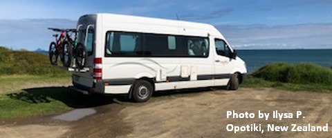
Click here for the White Sprinter Van map of the world!!!
Road and Mountain Biking
**Alert** We have now entered freeze-thaw season. Multiple locations have been dropping below freezing overnight. This means that exposed trails will potentially be delicate and subject to damage. Please limit your riding to areas under the canopy.
Upcoming Events
It’s Tuesday. There’s Zen meditation at Trinity Body Arts at 6am, free yoga at HAVEN in The Dalles at 5:30pm, and meditation with the Pacific Hermitage Monk(s) at 6:30pm at Yoga Samadhi in White Salmon. Thursday is the Turkey Trot Fun Run from the Hood River end of the Twin Tunnels. This benefits the Mosier School.
Random Morning Thoughts
Click here for the full events calendar.
Have an awesome day today!
Temira
