


Thank you for using this forecast. I offer it freely so you can have more fun and plan your life. It does take significant time and energy to produce. If you find yourself using it often, or if you feel your life is more awesome because of my work, please make a donation. You can get this forecast via email by donation. The email subscription isn’t $99/year. Not $50/year. Donating $12.34 or more gets you on the list for 12 months. Thank you for your support and thank you for trusting my forecast.
Click here to donate using a credit card.
Click here to donate via PayPal.
Venmo: @theGorgeismyGym
Snail Mail: PO Box 841, Hood River, Oregon 97031
Get the email version free through the end of January – try it out! Click here.
| 4a-8a | 8a-12p | 12p-4p | 4p-8p | 8p-4a | |
|---|---|---|---|---|---|
| Thursday 0′ |
 |
|
|
|
|
| Friday 0′ |
 |
 |
 |
|
 |
| Saturday 0′ |
|
|
 |
|
|
Mt. Hood Weather Forecast
It’s another sunny and cold morning on Mt. Hood, and it’ll stay that way today before a pattern change kicks in on Friday. That pattern change will bring fresh powder, real powder, to the mountain. Sadly, forecasts have backed off on the amounts, but it’ll still be enough for good times!
For Thursday, it’ll be sunny and cold and dry on Mt. Hood. The free air freezing level will be at the surface. Temps will be in the low double digits early and in the low 20’s this afternoon. Light and variable wind.
Friday starts off with high clouds. A few scattered flurries may fall in the day. Heavier snow arrives in the evening. The snow level will be at the surface near Mt. Hood with mountain temps in the low 20’s. Models disagree on how much snow will fall overnight, predicting 0.2” to 0.7” water value (WV). Call it 3-9” of champagne powder, and vote for the NAM forecast. Fluffy, dry blower powder. Wind Friday will be W 10 early, WSW 20 in the afternoon, and SW 20 after midnight.
Light snowfall continues Saturday morning before the sun breaks out in the afternoon. A few scattered flurries may fall overnight. The snow level will be at the surface with mountain temps in the low 20’s early and single digits to teens in the afternoon and overnight. Wind will be SW 20 early, SSW 15 in the afternoon, and light and variable overnight.
Sunday brings clouds with scattered snow flurries. The snow level will be at the surface. Mountain temps will be in the single digits as the coldest air of the season settles over us. Up to 0.2” WV falls during the day, for 1-3” (probably the low end) of light, fluffy powder. Wind will be light and variable early, WNW 10 in the afternoon, and NNW 35-40 overnight. That direction of wind should result in heavy orographic snowfall Sunday night into Monday, but we’ll have to wait and see how the model details pan out.
For Thursday, we’ll have easterlies: 35-40 this morning near Rooster Rock with 20-25 near Stevenson and Viento. The wind will bump up about 5mph midday and end up at 30-35 at both Rooster and Stevenson this afternoon. Friday starts with 20-25 near Rooster and 15-20 near Stevenson. The wind ends up light easterly and builds overnight. By Saturday morning, we’ll have easterlies at 35-40 at Rooster and Stevenson. The wind will spread into the metro area midday with 30-35 out of the east and blizzard conditions through the Gorge.
JONES, SAUVIE’S, COAST: now on vacation for the fall and winter. Will return in spring.
Virtual Spin – video, beats, friends, BIKES!!
Got a schedule that makes it hard to link up with scheduled classes? No worries, we got you. Our virtual spin program gives you access to our all new Spin Studio built for our Cycling program. Connect up with Virtual Classes led by a live coach, or with voiceover some fresh beats and paired with Scenic Rides all over the world. You can even hit one button and play your favorites from NetFlix and a variety of other media services. Or jam out to tunes and catch up with your friends for an all-time great experience in a private studio. Bike Max is 10 people. Meet up with your friends on your schedule and keep your cycling fitness strong all winter long!Get signed up now by clicking here!
Hood River Weather Forecast
It’s cloudy and cold out there, but the sun should come out later. Temps will be near 20 early and in the low 30’s later. East wind. No rainbows. Friday looks cloudy with scattered flurries that turn to heavy snow mid-evening. Temps will be in the mid 20’s early and mid 30’s later. 3-6” of snow overnight. East wind. No rainbows. Light snow continues Saturday for another 2-3” of accumulation. Temps will be in the mid 20’s early and near 30 in the afternoon. East wind. No rainbows. Models disagree on the weather after Sunday.
For weather specifically directed at travel through the Gorge, please visit Temira’s Awesome Travel Advisory Service on Facebook.
White Sprinter Van of the Week!
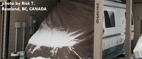
Click here for the White Sprinter Van map of the world!!!
Road and Mountain Biking
As you can see by looking out your window, we have entered fat bike season. All the trails are snowy. We have also entered trainer bike season.
Upcoming Events
There’s by-donation yoga at 8am at Flow. That’s followed by $5Tai Chi at the Hood River Adult Center at 2:30, community yoga at 6pm at Samadhi in White Salmon, and free Tai Chi at Our Savior Church in Bingen at 6. There’s Zumba at Mid-Valley elementary at 6:30. At 7am on Friday, there’s the Kickstand Coffee Run, where jogging or walking 4 miles gets you a free cup of coffee and a donut. There’s a by-donation yoga class at Yoga Samadhi at 4:15 on Friday afternoons.
Random Morning Thoughts
Click here for the full events calendar.
Have an awesome day today!
Temira
