

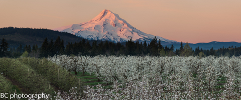
Mt. Hood Snow Forecast
To say that there has been massive snowfall on Mt. Hood in the last couple of days would be a bit of an understatement. Even little Skibowl has been scoring, with over 4 feet of snow at their base. You know, they really do have the best nachos on Mt. Hood. Anyway, today, Sunday looks like another ridiculous day of snowfall on Mt. Hood. The snow level will be somewhere around 2000′, dropping to less than 1000′ after midnight. We’ll see .9” water value (WV) between 4am and 4pm, for 10-12” of fluffy powder. We’ll see another .6-.8” tonight (mostly due to orographic effects – we could even see more!) for 7-10” of dry, light fluffy happy powder. Wind today will be SSW 20 early, turning to W 40 around 1pm and becoming a little more WNW 40 overnight. Total accumulation: 17-22”. Continued after the chart…
 |
4a-8a | 8a-12p | 12p-4p | 4p-8p | 8p-4a |
|---|---|---|---|---|---|
| Sunday 2000′->1000′ |
 |
|
|
|
|
| Monday 1000′->0′ |
|
|
|
 |
|
| Tuesday 0′ |
 |
 |
 |
|
|
Mt. Hood Snow Forecast, continued…
Monday currently looks a bit confusing in the models, at least in terms of snowfall. The precip model is insisting on a lot of snow, and the sounding model is thinking the moisture will be concentrated at lower levels. So, we’re going to cut the predicted numbers in half and hope for the higher end. The snow level on Monday will be 1000′, dropping to the surface (at least in the Gorge, maybe not in the metro area… yet) in the evening. We’ll see .3-.4”+ WV between 4am and 4pm for 4-5” of fluffy new. We’ll see a break in the afternoon, followed by another .3” WV between 7pm and midnight, for another 3-4” of snow. Wind on Monday will be WNW 35-40 early, fading to W 20 in the afternoon and becoming light and variable in the evening.

Say “thanks for the forecasts”
by making a donation!
Keep the forecasts coming.
Does this forecast save you time, gas money, or help you have more fun in your life? Make a donation to support continued forecasting, and get the forecast in your inbox each day. Click on the button to donate. The email subscription isn’t $99/year. Not $50/year. No, just $12.34 or more gets you on the list for 12 months. Don’t PayPal? Send a check to Temira @ PO Box 841 in Hood River. Thank you for your support and thank you for trusting my forecast.

Mt. Hood Snow Forecast, finished
Tuesday may see some flurries in the morning, but the sky will turn clear by midday. The free air freezing level will be at your house all day long, with temps on the hill in the low double digits. Wind will be light and variable all day.
The long-range models were down this morning, ending at 4am on Wednesday. The mountain currently looks clear and cold with east wind on Wednesday. The NAM and GFS disagree this morning on the chances of precip on Thursday. Both think the bulk of the moisture will stay to the south and east of us, but the GFS hints at us getting clipped Thursday at some point. We’re really going to have to wait and see, because I’m flying blind without that long-range GFS this morning.
Simcoe Accounting
Simcoe Accounting, LLC is a full-service accounting firm. Serving clients throughout the Columbia gorge, dedicated to providing our clients with professional, personalized services and guidance in a wide range of accounting and business needs. We believe in getting it right the first time. The right service at the right time, at the right price. Contact us for a free quote by clicking the headline above.
Gorge Wind Forecast
This is so tricky! With high pressure offshore and a low pressure system headed for Vancouver Island and a front headed our way, we should theoretically see a west wind push today. I’m going to trust in the 4/3 GFS and say we’ll see light westerlies after 1pm with 13-16 possible in Steven’s Locks and areas east of The Dalles. Monday starts with W 5-10 and turns east at 5-10 after 4pm. Look for E 25-30 Tuesday morning with E 40 Tuesday afternoon. Wednesday currently looks like E 40-45.
Jones, Sauvie’s, Coast Beta Test Forecast
If you click right here , you’ll find NOAA’s coast forecast.
Random Morning Thoughts
I’m betting that a lot of you out there use the Hood River Weather Website for some of your weather needs. I find the chatroom particularly helpful for understanding what is going on in various parts of the Gorge.
For those of you who haven’t yet visited Hood River Weather, check it out. You can get all sorts of local weather information (temps, precip, records, cams, etc.) in one place.
This month happens to be Larry’s annual donation drive. Larry’s a good dude, and he’s retired. Your donations help him keep the site going. They also help him buy nachos at Everybody’s and his dinner and drinks at the kinda-weekly weather chatroom gatherings at various Gorge restaurants. If you like weather, you too can come to those meetups! Larry can make your social life better!
Anyway, if you want to make a donation to Larry for the Hood River Weather website, head on over, scroll below the chatroom, and click on the paypal button. Larry’s awesome. Hood River Weather is awesome. So are you. Have an awesome day.
Disclaimer required by my grad school program: I am not your therapist (but I could be 51 graduate school credits from now). I am your weather forecaster. Take everything I say with a grain of salt, and consult with your actual therapist about your mental health issues. One other thing: I plan to keep doing this forecast indefinitely, even when I am a therapist.
Gorge Weather Forecast
As I’m writing this, it’s 30 degrees and raining in Hood River. That means it’s not actually rain. It’s freezing rain. Break out the ice skates! I think (hope?) we’ll see temps warm above freezing around 1pm, dropping back below freezing under partly cloudy sky tonight. On the other hand, the west wind that’s predicted for tonight might keep us above freezing. So, if we have west wind, we’ll be 30 degrees early and 33 degrees tonight. If not, we’ll just stay at 30 all day and night. There. I like that forecast. We’ll also see rain through 2pm, followed by a break, followed by showers in the evening. 87% chance of rainbows.
Models currently suggest rain or freezing rain on Monday morning, a break midday, and snow overnight. Temps will somewhere between 29 and 34 on Monday morning, probably staying there all day, and dropping into the upper 20’s Monday night. We’ll see an inch or two of snow on Monday night. Light west wind early, light east wind later. 76% chance of rainbows.
Tuesday looks like a Nothing day with low clouds. Temps will be in the upper 20’s early and upper 20’s to low 30’s later. Below freezing for sure. East wind. No rainbows. The rest of the week looks cold, with our first possible chance of precip coming Thursday, but models currently think the bulk of the moisture will stay to our south.
It’s worth noting that all this snow on the ground is going to contribute to a feedback loop of cold temps. If the sky clears at night, we’re going to be down in the single digits by the end of the week, most likely.
For weather specifically directed at travel through the Gorge, please visit Temira’s Awesome Travel Advisory Service on Facebook.
White Sprinter Van of the Day
Road and Mountain Biking
You can ride your bike if you have a fat bike. =)
Upcoming Events
Oh for goodness sake. There’s freezing rain. Who knows what events are on or off today?!?!
Have an awesome day today!
Temira
