


Thank you for using this forecast. I offer it freely so you can have more fun and plan your life. It does take significant time and energy to produce. If you find yourself using it often, or if you feel your life is more awesome because of my work, please make a donation. You can get this forecast via email by donation. The email subscription isn’t $99/year. Not $50/year. Donating $12.34 or more gets you on the list for 12 months. Thank you for your support and thank you for trusting my forecast.
Click here to donate using a credit card.
Click here to donate via PayPal.
Venmo: @theGorgeismyGym
Snail Mail: PO Box 841, Hood River, Oregon 97031
Get the email version free through the end of January – try it out! Click here.
| 4a-8a | 8a-12p | 12p-4p | 4p-8p | 8p-4a | |
|---|---|---|---|---|---|
| Saturday 1500′->0′ |
 |
|
 |
 |
 |
| Sunday 0′ |
|
|
|
|
|
| Monday 0′ |
|
|
|
|
 |
Mt. Hood Weather Forecast
A ginormous powder dumping Friday night into Saturday morning is setting up an epic day on the hill. Additional snow arrives during the day Saturday, Saturday night, and on through Monday evening. Models aren’t quite agreeing on the path of an incoming system on Monday; the outcome means the difference between snow (most likely) and rain (unlikely) on Mt. Hood. More about that later.
For Saturday, it’s gonna be very snowy. The snow level will be 1000′-1500′ during the day and 0′ overnight. We’ll see about 0.4” water value (WV) during the day, for 4-5” of fluffy powder. Another 0.6” to 0.8” WV arrives overnight, dropping 6-9” of fluffy snow. Wind will be W 40 early, W 20 mid-morning, WSW 20 in the afternoon, and SW 10-15 overnight.
Snow continues on Sunday, but we should see a period of sunshine or partly cloudy sky or perhaps fog from mid-morning on through mid-afternoon. The snow level will be 0′. About 0.3” WV falls during the day, for 3-4” of powder. 0.4” additional precip arrives overnight, taking the form of 4-5” of dry, fluffy powder. Wind Sunday will be SW 10-15 during the day, W 20 in the afternoon, and SE 10 overnight.
Monday’s tricky to forecast. The GFS and ECMWF agree on the general picture of moderate to heavy, cold, dry snow for Mt. Hood. The NAM swings this system much farther north, setting up a scenario where there’s heavy precip, but the p-type could change. For now, let’s call it 0.7” WV that falls as sweet fluffy powder: 8-9” during the day. Just a trace falls overnight. Wind will be SE 10 early, light and variable in the afternoon, and W 5 overnight. Models suggest a break in the weather Tuesday followed by more snow Wednesday.
Gorge Wind
Saturday starts off with W 13-16 east of the Deschutes and 5-10 west of there. By daybreak, or shortly afternoon, the wind will turn to light easterly in all locations. Sunday starts with E 25-30 from the metro area to Viento. The wind will back off to 20-25 in the afternoon and build overnight. By Monday morning, we’ll have 20-25 in Portland, 40-45 near Rooster Rock, and 25-30 near Viento and Cascade Locks. The wind will back off to E 10-15 in the afternoon.
JONES, SAUVIE’S, COAST: now on vacation for the fall and winter. Will return in spring.
Virtual Spin – video, beats, friends, BIKES!!
Got a schedule that makes it hard to link up with scheduled classes? No worries, we got you. Our virtual spin program gives you access to our all new Spin Studio built for our Cycling program. Connect up with Virtual Classes led by a live coach, or with voiceover some fresh beats and paired with Scenic Rides all over the world. You can even hit one button and play your favorites from NetFlix and a variety of other media services. Or jam out to tunes and catch up with your friends for an all-time great experience in a private studio. Bike Max is 10 people. Meet up with your friends on your schedule and keep your cycling fitness strong all winter long!Get signed up now by clicking here!
Hood River Weather Forecast
It’s high overcast out there this morning. We’ll see rain showers this morning, scattered wet snow flurries this evening, and steady snow after midnight. 4-8” accumulation. Temps will be in the mid 30’s early, low 40’s later. Light west wind early switches to light east after daybreak. 89% chance of rainbows. Sunday starts off with light snow and turns dry in the afternoon. Up to 1” during the morning. Heavier snow starts up after midnight with up to 7” by the time the snow stops Monday afternoon. Temps will be in the low 30’s early and mid 30’s later. East wind. No rainbows. Steady snowfall early Monday tapers off in the afternoon. Temps will be in the upper 20’s early and low 30’s later. Strong east wind early. Light east wind later. No rainbows.
For weather specifically directed at travel through the Gorge, please visit Temira’s Awesome Travel Advisory Service on Facebook.
White Sprinter Van of the Week!
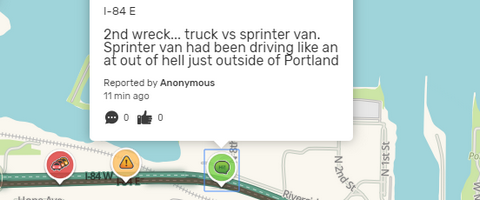
Click here for the White Sprinter Van map of the world!!!
Road and Mountain Biking
Silly rabbit… it’s not biking season in the Gorge. It’s XC skiing and BC skiing season! Wax those skis with some red and get out and play in the snow!
Upcoming Events
Once again, the weather is interfering with events. The normally scheduled 3pm Cold Lap at Dirty Fingers has been replaced by an afternoon movie showing. Grab some popcorn and come by the shop at 3pm for screen time. Weather recovery happens Sunday morning at Yoga Samadhi with by-donation yoga.
Random Morning Thoughts
Click here for the full events calendar.
Have an awesome day today!
Temira
