

GORGE WIND FORECAST
If you’re still seeing yesterday’s and it’s after 9am, try opening this in an incognito window AND/OR FLUSHING YOUR CACHE or do a do a hard refresh (Ctrl+Shift+R / Cmd+Shift+R)
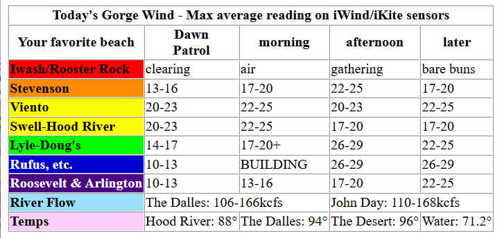
Keep in mind that this forecast attempts to predict what the iKite/iWind sensors will read. Think like a local! All sensors are not equal. Swell reads low. Viento/Arlington/The Wall read high compared to Swell. 30mph at Rufus (The Wall sensor) is about 23-24mph at Swell. 30mph at Swell is about 35-37mph at Rufus/Viento/Arlington. Hope that helps!
SHORT-TERM gorge wind forecast

Hi friends! One last day of west wind is in the Gorge wind forecast before we tumble into a heat wave. Along with the heat, moderate easterlies are forecast Saturday and Sunday. Models like the idea of west wind potentially returning late in the day on Monday with a big west wind day on Tuesday. Fingers crossed – we often linger in the heat a day longer than initially forecast.
That said, both the GFS deterministic and the Euro ensemble peg Tuesday as a windy cooldown day despite the lack of forecast marine clouds in the metro area. Beyond that, there’s uncertainty in the models, but most of the Euro ensemble predicts solid westerlies each day after Tuesday – that said, it really depends on where high pressure ends up. Hold off on any solid planning for a day or two more until we have more info.
Friday started off with clear sky across the region and pressures of 30.12/30.02/30.01 with 1026mb offshore. Early wind was 16-19mph between Viento and Hood River with 7-10mph at Stevenson and the Rowena zone with light/variable wind east of The Dalles. Models suggest 17-20mph pretty much all day between Viento and Hood River with a late morning lull to 14-17mph possible at the Hatch.
In the afternoon, offshore high pressure strengthens. This gives us a shot at 21-24mph from Stevenson to Doug’s with 17-20mph at the Hatch, which generally does not like it when the metro area is clear. River flow over the last 24 hours was 176-201kcfs, river temp is 61.5F, and high temp forecast is 80F and sunny.

RIVER FLOW FOR SITES BETWEEN AVERY (EAST OF THE DALLES) AND RUFUS: CLICK HERE FOR JOHN DAY DAM FLOW.
RIVER FLOW FOR SITES BETWEEN STEVENSON AND DOUG’S BEACH (WEST OF THE DALLES): CLICK HERE FOR THE DALLES DAM FLOW

LONGER-TERM gorge wind forecast
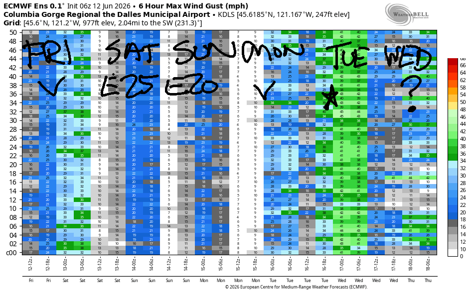
Breezy weather continues on Sunday, but it won’t be quite as windy as Saturday. There may be a brief Dawn Patrol of 22-25mph from Viento to the Hatch, but after that brief burst, early wind will be 19-22mph from Viento to the Hatchery. There may be a brief period of 22-25mph at the Hatch before the wind falls to 20-23mph and fills in from Stevenson to Doug’s. Afternoon wind rises to 22-25mph from Stevenson to Doug’s with the Hatch dropping to 17-20mph. Evening: Rufus joins at 22-25mph. High temps: 85 in Hood River, 91 in the desert.
A solid overall setup continues on Monday with the possible addition of some marine clouds in the metro areas. This sets up the another 22-25mph day. Strongest wind will be from Viento to the Hatch in the morning. Afternoon brings 22-25mph from Stevenson to Rufus. Tuesday may be slightly windier thanks to slipping temps on the west side – better cross-Cascade temp gradient generally equals more wind.
Wind range increases on Wednesday, but it should still be 20mph somewhere. Uncertainty skyrockets starting Thursday Lighter wind and hotter temps are nearly certain, but it’s unclear just how light the wind will be and just how hot the temps will get. Have a great week, everyone. Get some for me! See you on the Nch’i Wana soon!
Tip via venmo, cash or check
Want to subscribe to the email version, support Temira, and get the forecast earlier? Click on the blue box up above or use the methods below. Year-round is $29.99 or more if you think it’s worth more. Only need snow or only need wind? Warm season (May-Oct) or cold season (Nov-Apr) is $19.99 or more if you think it’s worth more. Thanks for your support!

JONES BEACH, SAUVIE ISLAND, & COAST FORECAST
Wind northerly unless otherwise indicated. For coast, it’s North/Central/South with the “central” at approximately Florence. Swell forecast from NWS for central coast. Jones: westerly unless otherwise stated. Sauvie Island: northerly unless otherwise stated.
Coast Saturday: 15/15-20/30-35, N swell 3′ at 5 seconds and W 3′ @ 11. Sunday: 15-20/20/30-35, N 4′ @ 6 and W 3′ @ 10. Monday: 15/20/30-35, N 4′ @ 6 and W 3′ @ 11. Jones Saturday: 19-22. Sunday: 21-24. Monday: 17-20. Sauvie Island Saturday: 12-15. Sunday: 16-19. Monday: 14-17.
BARE BONES HOOD RIVER WEATHER FORECAST
Sunny today. Temps start in the upper 60s and rise to the upper 80s. Moderately strong westerlies. No rainbows. Sunday will be sunny. Temp start in the mid 50s and rise to the mid 80s. Moderately strong westerlies. No rainbows. Monday will be sunny. Temps start in the upper 50s and rise to the low 80s. Moderately strong westerlies. No rainbows.
BIKE TRAILS INFO
NEXT WORK PARTY: August 15th and September 5th on the 133 trail in Post Canyon. Meet at Post Flats Staging Area at 9am. Hosted by Hood River County.
CLOSED TRAILS: Anything south of the 44 Road due to the Grasshopper Fire / Forest Closure Order: for example – Boulder Lakes, Gunsight, Gumjuwac, Lookout Mountain, 450, Fifteenmile. ALL GREEN MOUNTAIN LANDS: Underwood Mountain, Whoopdee Trail. Kreps Land (Hospital Hill) is also closed due to fire danger. Please respect the wishes of the landowners (they are generous to let us use their lands most of the year) and stay off until these lands reopen.
TEMIRA’S AWESOME TRAVEL ADVISORY SERVICE
HYPERLOCAL WEATHER FORECAST FOR THE COLUMBIA GORGE
THE DALLES, HOOD RIVER, WHITE SALMON, TROUT LAKE, STEVENSON, CASCADE LOCKS, PARKDALE, ODELL, HUSUM, BZ, MILL A, WILLARD, GOLDENDALE, RUFUS, ARLINGTON, boardman

Good morning, neighbors! Today’s the last forecast until the 17th – I’m off to a retreat, and the housesitter/catsitter has declined to forecast. So I’ll see you when I return! Weather for the next week or so looks generally seasonable, intermittently smoky, and breezy through the middle of next week. The Dalles, Hood River, and the Hood River Valley are at high risk of an ICE storm for the next few days due to confirmed recent sightings of a scout in The Dalles, and an unable-to-disconfirm sighting in Hood River (yesterday). There is no rain in the forecast for the next week, and very little sign of potential precipitation in the next two weeks. Fire danger: Red Flag Warning today, and high fire danger until it rains again…. Highway 35 remains closed between Bennett Pass and Parkdale due to the Grasshopper Fire.
This morning started off hot in Hood River (68) and cool in Glenwood (44) and less smoky than it’s been but still quite smoky. High Lava Fire: 1490 acres. Grasshopper Fire: 54,223 acres. Around the world with our friends this morning, we have…
Bandar-e Mahshahr, Iran: 108, sunny, 29% humidity
Havana, Cuba: 83, partly cloudy 81% humidity
Muscat, Oman: 91 sunny, 76% humidity
Caracas, Venezuela: 74, sunny, 78% humidity
Nuuk, Greenland: 49, cloudy, 81% humidity
Gaza City: 88, sunny, 68% humidity
Ottawa, Canada: 73, partly cloudy, 90% humidity
Today in the Gorge, we’ll have warm, breezy weather. High temps: 85 in Stevenson, 88 in Hood River, 94 in The Dalles, and 96 in Pasco. West wind builds to 20-25mph this morning between Stevenson and Mosier. In the afternoon, we’ll have 20mph from Stevenson to Mosier, 25-30mph from Lyle to Bob’s Texas T-Bone, and 20-25mph near the Arlington Triangle.
Overnight into Sunday morning, temps fall to the 50-60 degree range. A few low clouds might wander into areas west of Wyeth, but they’ll burn off quickly. A few high clouds swing inland from west to east during the day. Temps max out at 82/85/91/93. West wind starts at 25-20mph from Viento to Hood River and builds to 20-25mph between Stevenson and Celilo Village. Monday looks nearly identical minus two degrees of heat. Tuesday looks nearly identical to Monday.
There’s more uncertainty in the Gorge weather forecast from Wednesday on – models have 7+ degrees degrees of range in the potential high temps starting Wednesday and continuing into the future. Generally speaking, the weather looks warmer starting Thursday or Friday and continuing until I’m back in town. I’LL MISS YOU PEOPLE!!! Safe travels. -TATAS
HEY! DON’T STOP READING! Is this community-focused forecast helpful to you? It sure is! It takes me a couple hours a day to write. Please join your friends and neighbors in contributing to keep it going. Venmo: @thegorgeismygym PayPal: twomirrors@gmail.com USPS: Temira / PO Box 841 / Hood River, Oregon 97031