

GORGE WIND FORECAST
If you’re still seeing yesterday’s and it’s after 9am, try opening this in an incognito window
SHORT-TERM gorge wind forecast
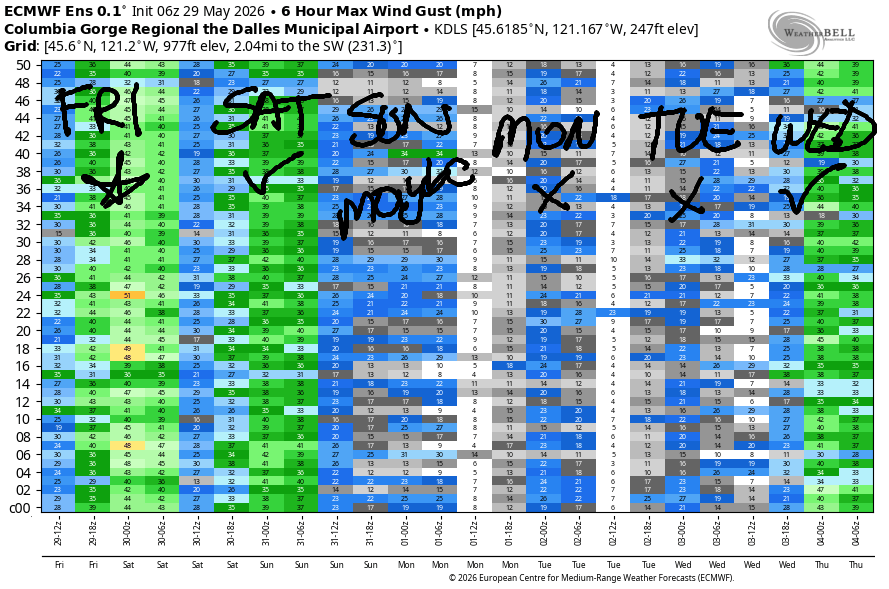
Hi friends! Yesterday was pretty wild, wasn’t it? I was watching the storms from Cook-Underwood lookout. It was blowing perhaps 20-25mph at the hatch, and as the storm approached, the wind turned easterly. Thunderstorm action is done now – a cold front today stabilizes things. Big westerlies are forecast today, and solid westerlies linger into Sunday. A light wind stretch (maybe even calm at times) is forecast Monday and Tuesday, when the mountain biking is likely to be epic thanks to yesterday’s rain. Your regularly scheduled west wind returns on Wednesday.
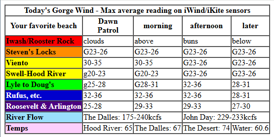
Looking at this morning (it’s Friday!), we have pressures of 29.89/29.82/29.75with 30.24 offshore. That gives us 0.07/0.07 and hints at wind all through the Gorge today. Early wind was 18-22mph from Stevenson to Hood river with 36mph at Viento. That zone was under the clouds and gusty. Between Lyle and Rowena (and probably Avery and Celilo), westerlies were 25-30mph to start the day. The Rufus zone was the early rock star with 33-36mph, and Arlington & Threemile were reading 25mph. Peak wind today will be prior to 3pm, but it’ll still be windy afternoon. Max average speeds hold in the 30-35mph zone between Lyle and Rufus and build to 30-35mph as far east as Hermiston through early afternoon.
After a cold front swings through mid-morning or midday, clouds slowly burn off on the west side, and the wind drops a bit to the east. From mid-afternoon on, we’ll have gusty 23-26mph from Stevenson to Mosier with 27-30mph from Lyle to Hermiston. River flow over the last 24 hours was 175-240kcfs (229-233kcfs at Rufus), river temp is 60.6F, and high temp forecasts range from 65F in Hood River to 74F way out east in the desert.
RIVER FLOW FOR SITES BETWEEN AVERY (EAST OF THE DALLES) AND RUFUS: CLICK HERE FOR JOHN DAY DAM FLOW.
RIVER FLOW FOR SITES BETWEEN STEVENSON AND DOUG’S BEACH (WEST OF THE DALLES): CLICK HERE FOR THE DALLES DAM FLOW

LONGER-TERM gorge wind forecast
Saturday’s a lovely setup: morning marine clouds, offshore high pressure, onshore temp gradient. We start with 20-23mph from Viento to Rufus with 14-17mph in cloudy Stevenson and east of Rufus to Hermiston. Stevenson to Avery builds to 22-25mph by mid-morning with 17-20mph at Rufus and Arlington. Afternoon: 26-29mph from Viento to Rufus with the Hatch likely falling to 19-22mph, although lingering marine clouds, if we’re lucky, could keep the Hatch going to. Late in the day, after 5pm, the wind fills in to Threemile at 23-26mph. High temps: 67F in Hood River and 73F in the desert.
Similar conditions are forecast on Sunday – partly cloudy on the west side to start and clear to finish. Early wind will be 22-25mph from Viento to Mosier with 17-20mph at Stevenson and 13-16mph east of Mosier out to Hermiston. There will be a few ups and downs to the wind, most notably a midday dip at the Hatch, but we’ll finish with 23-26mph from Mosier to Avery with 18-21mph from Stevenson to Hood River. Highs range from 73F in Hood River to 77F in the desert.
Lighter wind, potentially even becoming calm, is in the cards on Monday as hotter weather settles in over the region. Tuesday starts calm. If we’re lucky, we’ll see 13-16mph from Stevenson to Hood River in the afternoon, but no promises. As of this morning, Wednesday’s looking like 25-30mph as cooler weather return. Some sort of westerlies are likely to persist next week as cooler, seasonable weather persists. See you on the Nch’i Wana soon!

Was that helpful? I knew it was! Guess what? All of this crucial work – from your personal wind and snow reports to the invaluable TATAS updates – is made possible by my relentless efforts. Maintaining this labor of love isn’t easy. Each daily forecast takes hours. Website hosting, weather model access, and back-end admin work takes time and money. That’s where you come in.
YOUR CONTRIBUTION MAKES A DIFFERENCE
- SUPPORT ACCURATE, HYPER-LOCAL WEATHER FORECASTING
- ENABLE ACCESS FOR ALL, EVEN THOSE WITH LESS MEANS
- SUPPORT A COOL HUMAN WHO WORKS HARD SO YOU CAN PLAY
Take a moment to click one of the buttons below. Donate $19.99 or more (how much does this forecast enhance your life?) and get the email in your inbox. Whether it’s a renewing subscription (auto-renew) or a one-time donation, every contribution makes a real difference. Help me keep this labor of love alive, so we can all continue playing, commuting, and living in the Gorge with peace of mind and the best weather forecasts possible. Thank you!


Hood River, Oregon 97031


JONES BEACH, SAUVIE ISLAND, & COAST FORECAST
Wind northerly unless otherwise indicated. For coast, it’s North/Central/South with the “central” at approximately Florence. Swell forecast from NWS for central coast. Jones: westerly unless otherwise stated. Sauvie Island: northerly unless otherwise stated.
Coast Friday: 15-20/15/25-30, NW swell 8′ @ 14 seconds. Saturday: 15/15-20/30-35, NW 6′ @ 11. Sunday: 20-25/25/35-40, NW 6′ @ 11. Jones Friday: 21-24. Saturday: 19-22. Sunday: 17-20. Sauvie Island Friday: NNW13-16. Saturday: N15-18. Sunday: 14-17.
BARE BONES HOOD RIVER WEATHER FORECAST
Mostly cloudy this morning and mostly clear later. Temps start in the upper 50s and rise to the mid 60s. Moderate westerlies early. Strong westerlies later. 11% chance of rainbows. Saturday will be partly cloudy. Temps start in the mid 40s and rise to the upper 60s. Moderately strong westerlies. No rainbows. Sunday will be partly cloudy then clear. Temps start in the mid 40s and rise to the low 70s. Moderately strong westerlies. No rainbows.
TEMIRA’S AWESOME TRAVEL ADVISORY SERVICE
HYPERLOCAL WEATHER FORECAST FOR THE COLUMBIA GORGE
THE DALLES, HOOD RIVER, WHITE SALMON, TROUT LAKE, STEVENSON, CASCADE LOCKS, PARKDALE, ODELL, HUSUM, BZ, MILL A, WILLARD, GOLDENDALE, RUFUS, ARLINGTON, boardman

Good morning, neighbors! That was one hell of a thunderstorm last night, eh? Outflow winds caused all sorts of damage in Arlington, High Prairie, Parkdale, and probably other places judging by the prevalence of power outages. Lightning struck a pole in Odell and took out power there, and there were thousands of lightning strikes across the region. Hopefully the accompanying rain doused fires, and hopefully the accompanying rain didn’t do too much damage to cherry crops.
I’ve been trying to find a historical precip totals map this morning and haven’t had any luck. When I looked last night, White Salmon was nearing an inch, Arlington had received 1.1”, and the rain rate was over 3” per hour! Hood River ended up setting a record yesterday with 0.73” rain! Atmospheric instability is done now, but we will have a few spots of drizzle west of Hood River this mroning. Up next: a couple of cool days followed by a warming trend Monday and Tuesday (thankfully short-lived) and cooler weather for the following several days.
Today’s Gorge weather forecast
I’d look around the region this morning, but many weather stations (especially on the WA side) are offline. Temps were generally running 50-55F away from the Nch’i Wana and 55-60F along it. We had mostly cloudy sky to the west and partly cloudy sky to the east to start. We’ll see some drizzle west of Hood River this morning thanks to a cold front. Afternoon brings temps in the low 60s to the west, mid to upper 60s in The Dalles, and mid 70s out near Pasco. Thanks to that temp gradient, westerlies build to 30-35mph east of The Dalles and 25-30mph west of The Dalles. Dewpoints fall this afternoon following the passage of a cold front that sweeps out some of the lingering mugginess.
Saturday’s Gorge weather forecast
Saturday looks downright pleasant. Early in the day, temps aloft range from -1C to the west and +4C to the east. We”ll have west wind in the 15-20mph range along the river to start the day with partly cloudy sky. Dufur and Glenwood will drop to 31-35F. Upper Valley and Trout Lake: 37-40F. Everyone else: low to upper 40s. In the afternoon, we’ll have a few low clouds to the west and mostly clear sky east of Hood River. West wind builds to 20-25mph west of Mosier and 25-30mph from Mosier to Rufus with 15-20mph near Arlington Triangle. Temps range from SIX-SEVEN degrees in Hood river to 70 in The Dalles and 73 in Pasco.
Extended Gorge weather forecast
Sunday looks almost identical to Saturday but slightly warmer: 73F in Hood River and 76-77F from The Dalles into the desert. Much warmer weather is forecast on Monday: 81-84F with light wind. Tuesday: 85-91F with calm wind to start and westerlies at 15mph in the afternoon. On Wednesday, temps drop. How much they’ll drop is still uncertain – perhaps 10-15 degrees from Tuesday’s highs. Not only will this be a nice change, it’ll fire off the west wind which will make the wind johnnies happy. Perfectly pleasant (under 80F) weather continues into the end of the week and probably into next week. Holy shit! It looks like a great week for gardening! Safe travels. -TATAS
HEY! DON’T STOP READING! Is this community-focused forecast helpful to you? It sure is! It takes me a couple hours a day to write. Please join your friends and neighbors in contributing to keep it going. Venmo: @thegorgeismygym PayPal: twomirrors@gmail.com USPS: Temira / PO Box 841 / Hood River, Oregon 97031 You can test out the forecast subscription for a few days for free by signing up below. Easy! Do it!
MT HOOD SNOW FORECAST

QR codes and links for end-of-season tips – thank you!!!
Cash/check: Temira – PO BOX 841 – Hood River, Oregon 97031


Leave a Reply