

GORGE WIND FORECAST
today’s gorge wind forecast
Hi friends! It’s a sunny Sunday morning, and we’ve got one, maybe two rest days on tap. I’m gonna take this opportunity to organize my car – I’m not sure how many foils, wetsuits, and cases of SpinDrift are in there, but now seems like a good time to reset and vacuum. You lemme know if you want to come over and do your car! Back to the Gorge wind forecast – we might get westerlies in the teens or low 20s on Monday evening, but we’ll definitely be back to wind on Tuesday. Wednesday looks like the strongest day of the week, and then we should have westerlies of 17-20mph or more all the way through next weekend; there’s still plenty of uncertainty in how windy it will be each day, but the overall setup looks good.
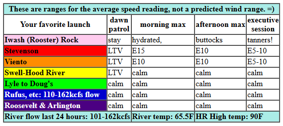
Taking a look at Sunday morning, there’s not much to see. Pressures were 30.16/30.14/30.16 for gradients of 0.02 (pdx-dls) and E 0.02 (dls-psc). Wind to start the day was light and variable everywhere. Easterlies pick up to 15mph between Stevenson and Home Valley for a couple of hours midday before fading to 5-10mph this afternoon. East of Home Valley, the wind eventually turns calm. River flow over the last 24 hours was 101-162kcfs, river temp is 65.5F, and high temp forecast is 90F for Hood River.
RIVER FLOW FOR SITES BETWEEN AVERY (EAST OF THE DALLES) AND RUFUS: CLICK HERE FOR JOHN DAY DAM FLOW.
RIVER FLOW FOR SITES BETWEEN STEVENSON AND DOUG’S BEACH (WEST OF THE DALLES): CLICK HERE FOR THE DALLES DAM FLOW

tomorrow’s gorge wind forecast
Monday’s going to be a hot one. If we’re very lucky, we’ll see evening westerlies. Expect light easterlies, 10mph or so, at Stevenson, Iwash (Rooster) Rock, and Home Valley early. The wind goes calm midday. Break out the e-foils and wakeboarding boats and sculling boats! Westerlies might return at 17-20mph after 5pm. Usually the wind is delayed in this sort of setup, so let’s call ourselves lucky if we do get that super-hot evening session. High temp: 97F and sunny.
extended Gorge wind forecast
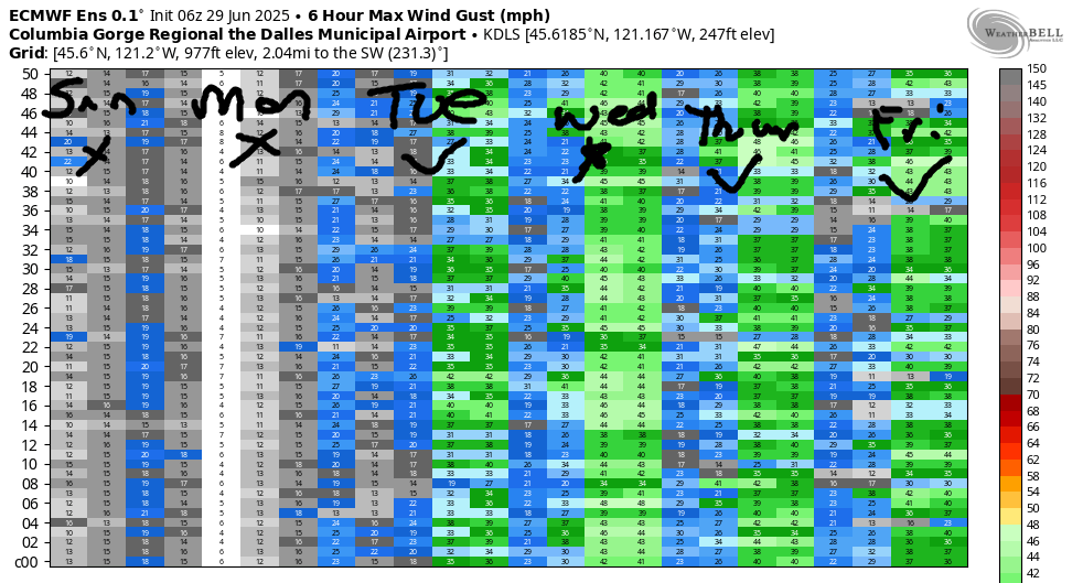
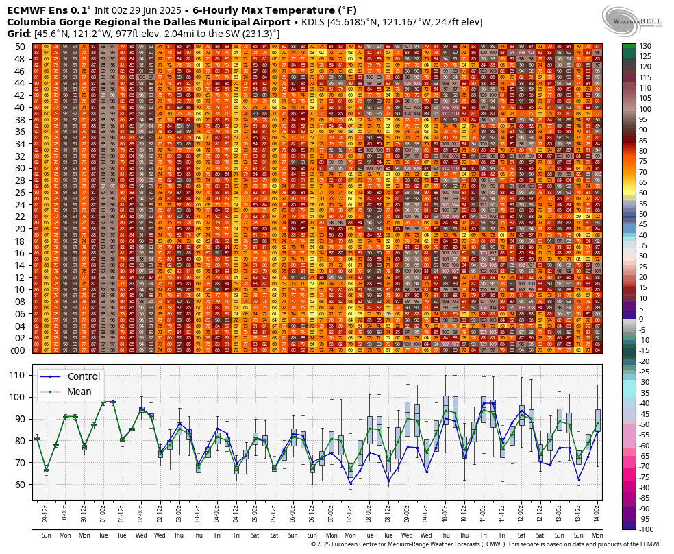
Models have knocked down the potential for a marine layer on Tuesday and thus knocked the wind forecast down a bit. Still… plenty of wind in the cards. Models suggest 20-23 from Viento to Mosier at dawn with 14-17 at Stevenson. To the east of Mosier: calm to start, or nearly calm. Thanks to a massive temp gradient across the Cascades, the wind will build throughout the day. Stevenson to Doug’s rises to 23-26 late morning or early afternoon. By mid-afternoon, we’ll have 26-29 from Stevenson to Rufus. Caveat to all this wind: given that the metro area will likely be clear of clouds all day, there’s a good chance that the wind will fall apart at the Hatch early afternoon – the “midday lull”. There’s also a good chance it will return in the evening for the Executive Session. High temp: 92F for Hood River and 98F out at Rufus. HOT!
Models have also backed off on the potential for marine clouds in the metro area and western Gorge on Wednesday, which leaves us with the same potential for the wind to fall apart near the Hatch in the afternoon. With that out of the way… we currently have a forecast of 26-30 from Viento to The Dalles in the morning and 28-32 from Viento to Arlington in the afternoon. Stevenson: High temp: 83F in Hood River and 88F in Arlington.
Beyond Wednesday, the ECMWF ensemble insists on moderately strong wind each day through Saturday. Uncertainty increases next Sunday, but there’s still a very good chance of 17-20mph or more. Ok. That’s 8 days of forecast. That’s probably plenty. Have a great day today. Find yourself a nice swimming hole near some big trees and settle in for the heat!
Was that helpful? I knew it was! Guess what? All of this crucial work – from your personal wind and snow reports to the invaluable TATAS updates – is made possible by my relentless efforts. Maintaining this labor of love isn’t easy. Each daily forecast takes hours. Website hosting, weather model access, and back-end admin work takes time and money. That’s where you come in.
YOUR CONTRIBUTION MAKES A DIFFERENCE
- SUPPORT ACCURATE, HYPER-LOCAL WEATHER FORECASTING
- ENABLE ACCESS FOR ALL, EVEN THOSE WITH LESS MEANS
- SUPPORT A COOL HUMAN WHO WORKS HARD SO YOU CAN PLAY
Take a moment to click one of the buttons below. Donate $19.99 or more (how much does this forecast enhance your life?) and get the email in your inbox. Whether it’s a renewing subscription (auto-renew) or a one-time donation, every contribution makes a real difference. Help me keep this labor of love alive, so we can all continue playing, commuting, and living in the Gorge with peace of mind and the best weather forecasts possible. Thank you!


Hood River, Oregon 97031


JONES BEACH, SAUVIE ISLAND, & COAST FORECAST
Wind northerly unless otherwise indicated. For coast, it’s North/Central/South with the “central” at approximately Florence. Swell forecast from NWS for central coast. Jones: westerly unless otherwise stated. Sauvie Island: northerly unless otherwise stated. Sunday: 25-30/20-25/30-35, W swell 4′ at 10 seconds. Monday: 20-25/20-25/30-35, NW 5′ @ 14. Tuesday: 20-25/20-25/35-40, SW 4′ @ 13. Jones Sunday: 13-16. Monday: 24-27. Tuesday: 24-27. Sauvie Island Sunday: 19-22. Monday: 20-23. Tuesday: 20-23.
BARE BONES HOOD RIVER WEATHER FORECAST
Clear sky all day today. Temps start in the upper 50s (open windows) and finish near 90 (close windows). Calm wind. No rainbows. Monday will be sunny. Temps start in the low 60s (open windows) and rise to the upper 90s (close windows, find air conditioning). Light westerlies most of the day. Moderate in the evening. No rainbows. Tuesday will be clear. Temps start in the mid 60s (open windows, barely) and finish in the low 90s (close windows, find AC). Moderate westerlies early. Strong westerlies in the afternoon. No rainbows.
TEMIRA’S AWESOME TRAVEL ADVISORY SERVICE – SUNDAY 6/29
HYPERLOCAL WEATHER FORECAST FOR THE COLUMBIA GORGE
THE DALLES, HOOD RIVER, WHITE SALMON, TROUT LAKE, STEVENSON, CASCADE LOCKS, PARKDALE, ODELL, HUSUM, BZ, MILL A, WILLARD, GOLDENDALE, RUFUS, ARLINGTON, boardman
Good morning, neighbors! It’s 7am as I write this, and all my windows and doors are open. We do this because cool air is curious and likes to enter homes. And then we can close the doors and windows and keep it safe until the next morning. Being air, it doesn’t mind being locked up all day with you and your pets. With hot weather forecast the next few days and warm weather the next few after that, go ahead and get used to this routine. Highlights of the week: triple digit heat from The Dalles eastward on Monday; mugginess Monday and Tuesday; strong west wind Tuesday and Wednesday; no rain on the cherries for the next couple of weeks, at least.
Glenwood this morning. Today’s gorge weather forecast.
Checking in with the 220 folks in Glenwood this morning, we see… everyone neglecting their coffee for a few minutes while they open the windows and doors to let in the curious cold. And cold it is: 45 degrees there to start the day. The rest of us started in the 50s. By afternoon, we’ll have 90 degrees (west), upper 90s (The Dalles), and low 90s (watermelon growing zones out east). Watermelons: happy. People: maybe a little less happy unless they’re sitting by a swimming hole in the depths of the forest.
monday’s gorge weather forecast
Monday looks even hotter, and to add to the fun, it’ll be muggy. The dewpoint rises from 45 in the morning to 59 in the afternoon. Temps rise to the low 60s in the morning to 97 (west) and 101 (The Dalles and areas to the east) in the afternoon. Calm wind is forecast until the evening, when westerlies pick up to 15mph or so between Stevenson and Mosier. East of there: hot and muggy and breezeless.
Canada Day gorge weather forecast
Expect a warm and muggy start to Tuesday, Canada Day. OH CANADA! We love you, and not just because you have Cheezies! Hood River’s record high-low Tuesday morning is 66 degrees. Will it fall? It’s going to be close – the current forecast low is 65 degrees. After that muggy, warm start, we’ll have a muggy, hot day; forecast highs are 92 (west), 98 (The Dalles) and 103 (watermelons). With the dewpoint forecast to be 56-59F all the way east to Boardman, the heat and humidity will feel intense. For here. Not for Florida, where the heat and humidity are bad, but they’re really the least of the problems. West wind returns on Tuesday. Expect 20-25mph early between Stevenson and Mosier. Afternoon wind rises to 25-30mph between Stevenson and Rufus with less to the east.
extended gorge weather forecast
High temps fall a few degrees on Wednesday. In response, the wind gets really excited, like big boner excited, and blows really hard: 30mph pretty much all day everywhere between Stevenson and the Arlington Triangle. Up in the hills, northwest wind is forecast at 20-25mph.
Thanks to the wind and the anomalously dry weather, fire danger on Tuesday and Wednesday will be extreme. Take whatever steps you need to take to protect your property. Consider carrying a fire extinguisher (or shovel and water) in your car in case you encounter fire. Put off your mowing and weed whacking and outdoor blacksmithing until another day. We’re all in this together. Let’s keep each other safe. Safe travels. -TATAS
HEY! DON’T STOP READING! Is this community-focused forecast helpful to you? It sure is! It takes me a couple hours a day to write. Please join your friends and neighbors in contributing to keep it going. Venmo: @thegorgeismygym PayPal: twomirrors@gmail.com USPS: Temira / PO Box 841 / Hood River, Oregon 97031 You can test out the forecast subscription for a few days for free by signing up below. Easy! Do it!
Leave a Reply