

GORGE WIND FORECAST
today’s gorge wind forecast
Hi friends! While there’s hope for wind in the eastern Gorge today, our long streak of windy days is about to come to an end. For some of you, the rest period in the Gorge wind forecastmight be welcome. For others of you, it’ll be disappointing. In light of this, I offer up the fact that we’re probably going to get enough rain in the next two days to make for excellent mountain biking conditions for a few days! But let’s dive in to the wind forecast, shall we?
First, if you haven’t made a contribution to Bingen Bart’s GoFundMe, please take the time to do so. Bart is the OG of wind forecasters for the Gorge, and he’s the OG for Meadows snow reporting. Last week, he lost everything in the Rowena Fire. Open up your heart and your wallet and send a few bucks his way. And as you contemplate how much you can afford to send his way, think of this: give with no regrets. Give so that you aren’t left wishing you’d given more, and give so you don’t regret giving more than you can afford. Let’s all step up and help Bart out in his time of need.
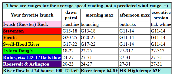
On to Friday’s forecast… A rainy weather system is headed for the Gorge today. Ahead of it, we’ll have a burst of wind for both the west side and the east side. For the afternoon, we’ll be relying on a thermal gradient. That’ll send you east of The Dalles for the best results. Early pressures were 29.92/29.82/29.72 for solid 0.10 (pdx-dls) and 0.10 (dls-psc). Ahead of this system, we’ll see gusty 17-22 for a short period of time from Viento to Swell and then from Mosier to Doug’s. Rowena remains off-limits due to the Rowena Fire. Once the low clouds (and maybe rain) arrive, areas under those clouds drop to gusty 11-14. For the afternoon, the focus shifts east: gusty 27-31, or perhaps a couple MPH more, from Avery to Threemile. Lyle/Doug’s will be right on the edge; it depends on how far east the low clouds penetrate. Areas east of Avery will be your best bet today. River flow over the last 24 hours was 100-155kcfs (113-171kcfs at Rufus), river temp is 64.8F, and high temp forecast is 62F for Hood river and 75F way out in the desert.
RIVER FLOW FOR SITES BETWEEN AVERY (EAST OF THE DALLES) AND RUFUS: CLICK HERE FOR JOHN DAY DAM FLOW.
RIVER FLOW FOR SITES BETWEEN STEVENSON AND DOUG’S BEACH (WEST OF THE DALLES): CLICK HERE FOR THE DALLES DAM FLOW

tomorrow’s gorge wind forecast
Saturday brings more extensive clouds, more extensive rain and significantly less wind. Areas west of Rufus stay under 15mph all day and will be under 10mph for much of the day. While the zone from Philippi Canyon to Boardman may start at 22-25mph, it will drop to 18-22mph or less in the afternoon. Remembering that those eastern Gorge sensors read high when compared to the Swell sensor, we probably won’t have enough wind to get you on the water unless you have really big gear. High temp: 60F for Hood River with rain and 69F out in the desert with some drizzle and sprinkles.
extended Gorge wind forecast
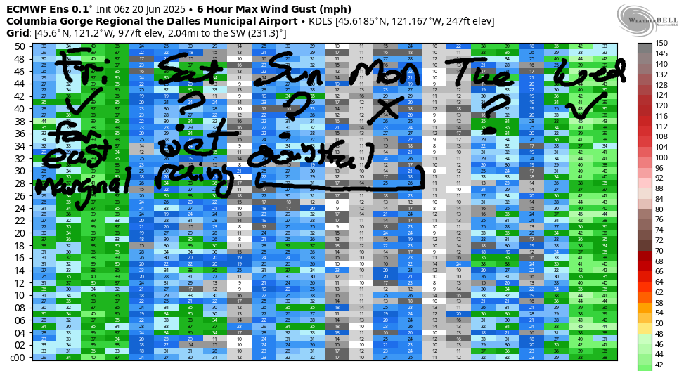
While the rain will come to an end on Sunday we won’t have much support for wind. A weak thermal gradient combines with weak offshore high pressure for perhaps 14-17 from Stevenson to The Dalles. Monday doesn’t look much better – temps equalize across the Cascades and leave us with little to drive the wind. There’s some hope for Tuesday as cooler air on the west side combines with lingering heat in the desert for late-day westerlies, but those often arrive later than forecast, which would put Tuesday’s wind after dark. Fingers crossed!. Better chances for stronger wind are in the cards on Wednesday, despite the setup being (as of now) not quite ideal. I think that’s enough days of forecast for now. Have a great day on the Nch’i Wana!
Was that helpful? I knew it was! Guess what? All of this crucial work – from your personal wind and snow reports to the invaluable TATAS updates – is made possible by my relentless efforts. Maintaining this labor of love isn’t easy. Each daily forecast takes hours. Website hosting, weather model access, and back-end admin work takes time and money. That’s where you come in.
YOUR CONTRIBUTION MAKES A DIFFERENCE
- SUPPORT ACCURATE, HYPER-LOCAL WEATHER FORECASTING
- ENABLE ACCESS FOR ALL, EVEN THOSE WITH LESS MEANS
- SUPPORT A COOL HUMAN WHO WORKS HARD SO YOU CAN PLAY
Take a moment to click one of the buttons below. Donate $19.99 or more (how much does this forecast enhance your life?) and get the email in your inbox. Whether it’s a renewing subscription (auto-renew) or a one-time donation, every contribution makes a real difference. Help me keep this labor of love alive, so we can all continue playing, commuting, and living in the Gorge with peace of mind and the best weather forecasts possible. Thank you!


Hood River, Oregon 97031


JONES BEACH, SAUVIE ISLAND, & COAST FORECAST
Wind northerly unless otherwise indicated. For coast, it’s North/Central/South with the “central” at approximately Florence. Swell forecast from NWS for central coast. Jones: westerly unless otherwise stated. Sauvie Island: northerly unless otherwise stated. Friday: W5-10/W5-10/W5-10, W swell 5′ at 10 seconds. Saturday: LTW/W10-15/LTV, W 7′ @ 9. Sunday: LTNW/N5-10/N25-30, NW 6′ @ 9. Jones Friday: 7-10. Saturday: LTV. Sunday: 13-16. Sauvie Island Friday: NW10-13. Saturday: S 5-10. Sunday: N10-13.
BARE BONES HOOD RIVER WEATHER FORECAST
Clouds this morning add some light drizzle or sprinkles this afternoon. Temps start in the mid 50s and rise to the low 60s. Light westerlies. 68% chance of rainbows. Saturday will be cloudy with drizzle. Temps start in the upper 40s and rise to 60 or so. Light westerlies. 79% chance of rainbows. Sunday will be cloudy then partly cloudy. Temps start in the upper 40s and rise to the low 70s. Light westerlies. No rainbows.
TEMIRA’S AWESOME TRAVEL ADVISORY SERVICE
HYPERLOCAL WEATHER FORECAST FOR THE COLUMBIA GORGE
THE DALLES, HOOD RIVER, WHITE SALMON, TROUT LAKE, STEVENSON, CASCADE LOCKS, PARKDALE, ODELL, HUSUM, BZ, MILL A, WILLARD, GOLDENDALE, RUFUS, ARLINGTON, boardman
Good morning, neighbors! Clouds have arrived. Rain is on the way. The Parka and RainGuard are hugging the cherries, and the cherry farmers are crossing their fingers. All the rest of us are crossing our fingers for them. After a couple of cool, cloudy, potentially drizzly days, we’ll dive right back in to warm weather and sunshine Sunday into the first half of next week. Then it’s back to cool and breezy for Wednesday. Then we repeat the cycle, minus any rain chances.
glenwood!
Let’s check in with Glenwood. It was 51 degrees there this morning, and all the witches and pagans were dancing in the streets (and will be all day) in celebration of the summer solstice. Hmm… that reminds me. Someone sent me a summer solstice party invite, and I have no idea who it was or through what medium I received the invite. Guess I will just go to bed at 8:30pm tonight like usual…
today’s gorge weather forecast
Back to today’s forecast: a bit of drizzle is already falling along the Cascades, but it’ll take some time for this incoming system to saturate the dry air. Dry air is like the sponge that’s been under your kitchen sink for two years. It takes a surprising amount of water to rehydrate it! Eventually, though, we’ll have some west-side drizzle today. Cascade Locks sees drizzle until 8pm with moderately heavy rain from 11am to 5pm or so. Models suggest light rain, or at least sprinkles, will push all the way to Mosier between 2pm and 8pm. Accompanying the rain will be west wind at 10-15mph west of The Dalles and 25-30mph from The Dalles to Threemile Canyon. High temps today won’t be all that high: low 60s (west) upper 60s (The Dalles) and mid 70s (watermelon growing areas near Hermiston).
saturday’s gorge weather forecast
Clouds stick around tonight as a second frontal system and cool trough move inland on Saturday. With the atmosphere already moist (like my skin during this morning’s first hot flash), we’re more likely to see widespread drizzle on Saturday. Even so, models are far from agreeing on the amounts. As of now, we’re looking at moderate rain west of Hood River from 5am to 8pm with mist or sprinkles or drizzle all the way to Arlington from mid-morning on into the evening. With flow out of the NW, it’s likely there will be a dry zone between Mosier and The Dalles for at least part of the day. South Wasco and Sherman counties also see light drizzle for much of the day. Wind will be minimal: 10mph west of Biggs and 20mph east of Biggs pretty much all day. Combine the wind and the rain for decent rainbows chances. High temps will be 60 (west – and close to a record low-high), 66 (The Dalles), and 69 (watermelons). That’s after a start in the upper 40s. My goodness. What a chilly day for June!
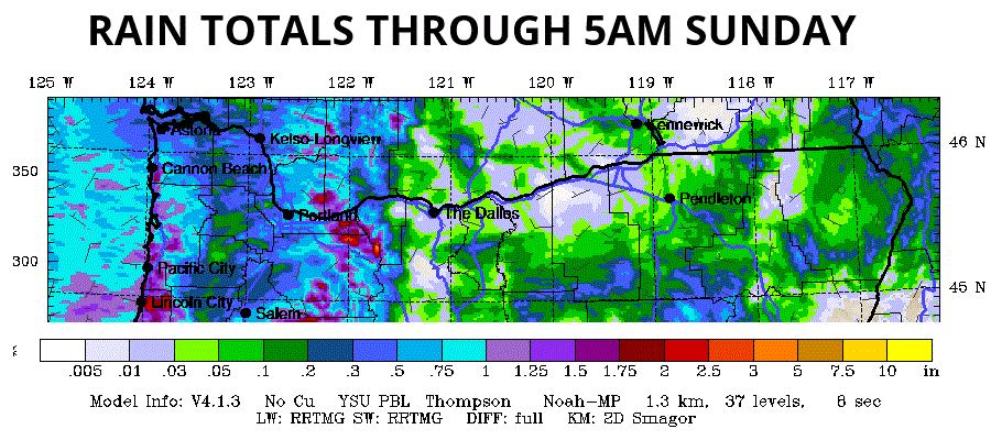
Rain total for the two days range from 0.05” to 0.15” for The Dalles. Cascade Locks, or at least the Cascade Crest, picks up 0.5” to 0.75”, which will be helpful in terms of (temporarily) knocking down fire danger.
sunday’s gorge weather forecast
Sunday morning starts out 50 degrees or so with clouds in the west and mostly cloudy sky to the east. Afternoon turns partly cloudy west of Mosier and mostly clear to the east. The combo of a moist (there’s that horrible word again) atmosphere and sunshine could fire off a few instability-driven showers; models suggest the Maryhill/Goldendale area would be the focus if that happens. Wind will be 10-15mph west of The Dalles and 5-10mph to the east. Highs range from 73 (west) to 77 (The Dalles and the watermelons).
extended gorge weather forecast
Dry, warmer weather is forecast Monday (80-85 for The Dalles) and Tuesday (85-90 for The Dalles) followed by a drop in temps and an increase in wind for the middle of next week. While there’s a lot of range in the forecast temps for the latter half of next week, models are pretty confident that we’ll warm back up into the 80-90 degree zone for next weekend, the last weekend of June. How in the world did we already get to the end of June? Safe travels. -TATAS
HEY! DON’T STOP READING! Is this community-focused forecast helpful to you? It sure is! It takes me a couple hours a day to write. Please join your friends and neighbors in contributing to keep it going. Venmo: @thegorgeismygym PayPal: twomirrors@gmail.com USPS: Temira / PO Box 841 / Hood River, Oregon 97031 You can test out the forecast subscription for a few days for free by signing up below. Easy! Do it!

Leave a Reply