

MT HOOD WEATHER FORECAST
Hey skiers and snowboarders! We’re still on track to pick up a bunch of snow this weekend, although the quantity for Sunday has dropped a bit. More on that later. Thinking about heading up today for some early morning cloudy, dry, excellent-snow Mt Hood Weather? Get on it – a couple inches of cold snow fell yesterday. Groom today is spectacular cold packed powder. Snowfall returns this evening and continues all the way into Monday morning. Next chance for dray weather: Tuesday and Wednesday.
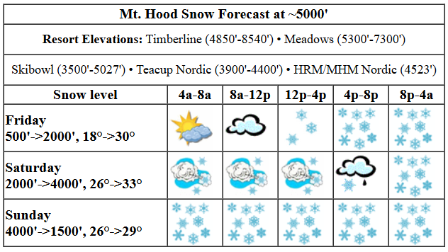
Friday kicks off cold and partly cloudy with awesome pack pow groom. Light snowfall returns this afternoon, and snow intensity picks up overnight. The snow level will be around 500′ this morning, 1500′ this afternoon, and 2000′ overnight. Temps rise from 18F this morning to 29F this afternoon. About 0.1” water equivalent (WE) is forecast by 5pm, for an inch of new. Overnight, we’re looking at 0.5” to 0.7” WE depending on how much help the strong W wind gives us. Call it 5-8” medium-dry powder. Wind will be S 10-15 this morning, SW 150-20 this afternoon, and W 45 after midnight.
Heavy precip continues all day Saturday and all of Saturday night. There’s some potential for a period of snain or mixed precip in the evening. Given the current forecast track for an incoming low (south of Mt. Hood), it’s most likely we’ll see dense, wet snow rather than rain. The snow level starts at 2000′, rises to perhaps 4000′ in the evening, and falls back to 1500-2000′ overnight. Temps rise from 27F to 33F and fall back to 27F overnight. About 0.8” WE is forecast during the day for 7-9” new snow. We could exceed that thanks to moderately strong wind and orographic assistance. Overnight, we’re expecting another 0.9” WE for 7-9” increasingly dry powder. Wind will be W 45 in the morning, WSW 35 in the afternoon, SW 15-30 in the evening, and W 20 after midnight. The early morning westerlies at 45mph could cause some lifts to run slowly, but it’s probably not going to result in anything more than the usual lifts (Cascade/Vista, for example) getting taken offline.
Snow continues on Sunday, but it’s unclear how much. It really depends on where the band of heaviest moisture sets up. When we looked yesterday, Mt. Hood was in the bullseye. As of this morning, the most intense precip is forecast to stay south of us. For now, let’s call it a foot of new snow evenly spread between the day and the night. Snow level max: 2500′, unless something changes dramatically. Temps should be in the mid to upper 20s. Wind: probably not more than 20mph, but subject to chance.
Monday and Tuesday may have a few scattered flurries, but they’ll mostly be dry. Temps: mid to upper 20s. Wednesday currently looks 100% dry. We’ll move back into a wetter pattern towards the end of the week, but the GFS and Euro have very different ideas on the p-type. The Euro is leaning colder with snow. The GFS is currently leaning warmer with a snowy start and rainy finish. Of course we’ll all vote for the Euro! See you on the snow!
Was that helpful? I knew it was! Guess what? All of this crucial work – from your personal wind and snow reports to the invaluable TATAS updates – is made possible by my relentless efforts. Maintaining this labor of love isn’t easy. Each daily forecast takes hours. Website hosting, weather model access, and back-end admin work takes time and money. That’s where you come in.
YOUR CONTRIBUTION MAKES A DIFFERENCE
- SUPPORT ACCURATE, HYPER-LOCAL WEATHER FORECASTING
- ENABLE ACCESS FOR ALL, EVEN THOSE WITH LESS MEANS
- SUPPORT A COOL HUMAN WHO WORKS HARD SO YOU CAN PLAY
Take a moment to click one of the buttons below. Donate $19.99 or more (how much does this forecast enhance your life?) and get the email in your inbox. Whether it’s a renewing subscription (auto-renew) or a one-time donation, every contribution makes a real difference. Help me keep this labor of love alive, so we can all continue playing, commuting, and living in the Gorge with peace of mind and the best weather forecasts possible. Thank you!


Hood River, Oregon 97031


GORGE WIND FORECAST

Hi friends! That was quite the squall that came through yesterday afternoon. Hopefully a few of you got some river rides from that one. Next chance for westerlies is Saturday as a cold front approaches and then moves through. All-in-all, the weather looks active for the next couple of weeks, and that means intermittent gusty west wind is possible. Friday starts with easterlies at 25mph at Iwash (Rooster) Rock and 10mph at Stevenson. By mid-morning, the wind builds to 25mph at both spots and holds for a couple hours. By early afternoon, the wind drops to 10mph at Iwash and slowly fades to 10mph by mid-afternoon at Stevenson. River flow over the last 24 hours was 123-164kcfs, river temp is 43.0F, and high temp forecast is 48F with clouds.
Saturday‘s setup is far from ideal, but a combo of a cold front moving through and 850mb wind at W 45mph will nudge westerlies into the “enough” zone. Expect intermittent showers between Stevenson and Swell all day with gusty 17-20mph through early afternoon. The wind between Stevenson and Doug’s drops to 10-13mph or less early afternoon and stays down. Out east, the day starts with gusty 23-26 from Avery to Boardman. Models suggest a period of 26-29mph, perhaps a touch more 11-2, from Avery to Boardman. After 2pm, the wind drops to the low 20s out east. Keep in mind that these predictions are to the sensors, and 26 at The Wall and Arlington is equivalent to a 19-20 reading at the Hatch. High temp: 49F with showers west of The Dalles and partly to mostly cloudy sky out east.
Sunday will be light and variable – light westerly or calm early and light easterly later. High temp: 46F with clouds in the morning and rain in the afternoon. Next chance for westerlies is Monday, when offshore high pressure briefly takes hold and gives us upper teens to low 20s from Stevenson to Rufus. Have an awesome day today!
BARE BONES HOOD RIVER WEATHER FORECAST
Clouds this morning, rain tonight. Temps start in the mid 30s and rise to the upper 40s. Light easterlies. No rainbows. Saturday will be showery all day. Temps start in the upper 30s and rise to the upper 40s. Moderate westerlies. 99% chance of rainbows. Sunday will be dry early and rainy the rest of the day. Temps start in the upper 30s and rise to the mid 40s. Light/variable wind. 11% chance of rainbows.
TEMIRA’S AWESOME TRAVEL ADVISORY SERVICE
HYPERLOCAL WEATHER FORECAST FOR THE COLUMBIA GORGE
THE DALLES, HOOD RIVER, WHITE SALMON, TROUT LAKE, STEVENSON, CASCADE LOCKS, PARKDALE, ODELL, HUSUM, BZ, MILL A, WILLARD, GOLDENDALE, RUFUS, ARLINGTON, boardman
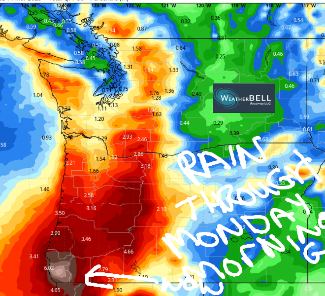
Good morning, neighbors! We’re about to tumble into a three-day period of wetness, a period that just might get us over the water year average. Yay! Currently Hood River is at -1.34” for the year. Take a look at the 50th percentile precip map and see if you think we’ll make a run on surplus. After a very wet weekend for many of us, we’ll drop into a short dry period to start next week. Then it’s right back into the moistness, the dampness, the wetness… Models hold out hope for a couple days of 60+ degree weather about 12 days from now. Keep that in your mind as the sky stays gray and the rain totals add up. Heading over the passes the next few days? Expect lots and lots of snow. Prepare for winter driving conditions.
glenwood. tatas eootd.
Let’s check in with Glenwood. It’s 26F there this morning with a dewpoint of 22F. TATAS Executive Order Of The Day: know what? I can’t even today.
today (it’s Friday, π day)
To start Friday (TGIF), we have high clouds above a Nothing. Rain arrives west of Hood River by 2pm and pushes east to The Dalles and Goldendale late afternoon.. South Wasco picks up some drizzle overnight. I can’t rule out a little snow for Parkdale, York Hill, Hood River Mountain, and elevated areas of Mosier tonight, but even if it does snow, it should be sloppy and wet (like my CAR, people), and just a little accumulation. Temps max out in the upper 40s in the lowlands today, and east wind at Iwash (cock) Rock and Stevenson fade from 25mph to 10mph.
saturday
Showery weather continues all day Saturday west of Rowena and also in the WA hills as far east as High Prairie or Centerville. Rainfall intensity ramps up late afternoon. Expect pouring rain Saturday evening all the way east to the Arlington Triangle (which looks suspiciously like a full bush in a bikini) and beyond. South Wasco and Sherman Counties also get a soaking. Those of you driving home from the metro area from late afternoon on into the night will be unhappy campers. Consider camping out in the city instead. Saturday’s temps max out near 50 in the lowlands. Wind will be W 15-25 west of The Dalles and 20-30mph to the east. Given the intense precip rates overnight, snow is possible (from evaporative cooling) anywhere at 1500′ or higher.
sunday
A brief break in the action Sunday morning gives way to… well, it depends on the path of an incoming low. It’s going to be wet Sunday, but it’s unclear if it’ll just be wet or torrentially wet. This uncertainty is disrupting my plans for a downpour jog, because I can’t downpour jog without a freakin’ downpour. FFS, Ma Nature! Rain tapers off on Sunday night and leaves us with a partly cloudy Monday. Sunday’s high temps: mid 40s. Wind: light/variable. Snow level: 2000′, but we can’t rule out it dropping lower if the precip rate really amps up.
extended gorge weather forecast
Monday, Tuesday, and Wednesday look mostly dry. After that, we drop right back into wet weather late next week. Details on this are less clear than the future of democracy in this country – the GFS is calling for warmer, wet weather next weekend, and the ECMWF keeps the temps cooler. Either way, the mountains should pick up at least some additional snowpack next weekend before the weather (probably) warms up…. about the time I take off for a month long retreat for April. Safe travels. -TATAS
HEY! DON’T STOP READING! Is this community-focused forecast helpful to you? It sure is! It takes me a couple hours a day to write. Please join your friends and neighbors in contributing to keep it going. Venmo: @thegorgeismygym PayPal: twomirrors@gmail.com USPS: Temira / PO Box 841 / Hood River, Oregon 97031 You can test out the forecast subscription for a few days for free by clicking this link: https://subscribepage.io/YhevGc
