

MT HOOD WEATHER FORECAST
Hey skiers and snowboarders! We’re back into a very active Mt Hood weather pattern for the next week or so – lots of precip in the forecast along with periods of cold-enough-for-snow temps. Today will be beyond exciting, as I’m sure many of you have heard, but the excitement is from thunder and lightning, not from powder. Mixed precip, potentially heavy, sticks around Thursday and transitions to snow by Thursday night. We then see light snow Friday, dry weather Saturday into Sunday morning, and another round of borderline-temp precip Sunday into Monday. On Tuesday, I take off for a month of silent meditation. I’ll be back forecasting early in May.
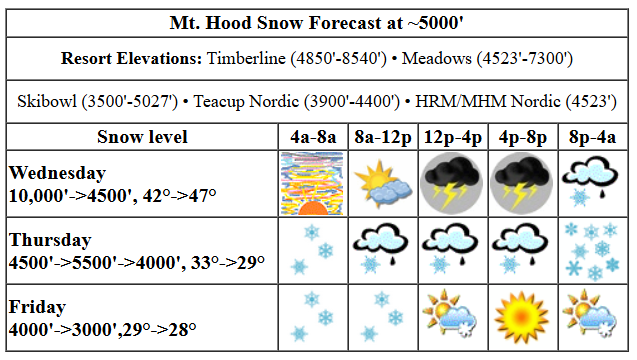
wednesday’s exciting mt hood weather forecast
Wednesday starts partly high overcast. By afternoon, thunderstorms, lightning, hail, and pouring rain are possible for Mt. Hood and the metro area, which is going to take a beating. Any lightning strike near Mt. Hood will shut lifts down for 45 minutes (at Meadows anyway), and given the setup, I’d be surprised if lifts come back. Get up there early. Sounds like the snow did not refreeze last night, so it should be a slushy start. The free air freezing level will be 11,000′ this morning. The snow level falls to 4500′ to 5000′ overnight. It’s completely impossible to tell you how much rain/snow we’ll pick up, as it’ll depend a lot on where thunderstorm cells develop. Given the high moisture availability, we could see lots of precip – up to a couple inches. If models are correct, temps at 5000′ will fall from the mid 40s this morning to 33F or so overnight, which gives us a shot at wet snow at 5000′ and heavy snow above that. Wind will be southerly today at 10-20mph until storms arrive. Then the wind is anyone’s guess – strong outflow gusts are possible from those storms.
thursday’s mt hood weather forecast
Mixed precip continues on Thursday and transitions to snow Thursday night. The snow level starts around 4500′, rises to 5500′ in the afternoon, and slowly falls to 4000′ after midnight. Models give us 0.3” to 0.4” mixed precip during the day. They follow that up with 1.0” to 1.2” WE overnight. Let’s call it 6-8” dense new snow. Wind will be SW 15-30 in the morning, S 20-40 in the afternoon, and SW 20-35 overnight.
extended mt hood weather forecast
Light snowfall Friday morning gives way to sun in the afternoon and light snowfall after midnight. The snow level will be 4000′ in the morning, 3000′ in the afternoon, and 2500′ after midnight. About 0.3” WE is forecast during the day for about 3” decent-quality new. Overnight: a trace. Wind: SW 25-35 all day. A trace of snow early Saturday gives way to dry, cloudy weather. Dry weather continues through midday Sunday and is then replaces by mixed precip. That’s all for now. See you on the snow!
Was that helpful? I knew it was! Guess what? All of this crucial work – from your personal wind and snow reports to the invaluable TATAS updates – is made possible by my relentless efforts. Maintaining this labor of love isn’t easy. Each daily forecast takes hours. Website hosting, weather model access, and back-end admin work takes time and money. That’s where you come in.
YOUR CONTRIBUTION MAKES A DIFFERENCE
- SUPPORT ACCURATE, HYPER-LOCAL WEATHER FORECASTING
- ENABLE ACCESS FOR ALL, EVEN THOSE WITH LESS MEANS
- SUPPORT A COOL HUMAN WHO WORKS HARD SO YOU CAN PLAY
Take a moment to click one of the buttons below. Donate $19.99 or more (how much does this forecast enhance your life?) and get the email in your inbox. Whether it’s a renewing subscription (auto-renew) or a one-time donation, every contribution makes a real difference. Help me keep this labor of love alive, so we can all continue playing, commuting, and living in the Gorge with peace of mind and the best weather forecasts possible. Thank you!


Hood River, Oregon 97031


GORGE WIND FORECAST

Hi friends! We have an exciting day on tap today, if not for wind, at least for weather. Not much happens in the next several days in terms of wind. Wednesday kicks off with easterlies as a low spins offshore. We’ll see peak speeds at 25mph at both Stevenson and Iwash (Rooster) Rock mid-morning before the wind drops in the afternoon. After 2pm, a weak low moves inland, and the atmosphere completely destabilizes in response to a variety of factors. While the flow will turn onshore, potentially strong enough to get you on the river, you should use situational (radar, in this case) awareness. If there are thunderstorm cells anywhere near, get off the river. Today’s setup is quite dangerous and could result in frequent lightning. River flow over the last 24 hours was 124-175kcfs, river temp is 46.0F, and high temp forecast is 73F.
Thursday starts with light west flow, less than 10mph. Wind direction quickly turns easterly. Iwash maxes out at 20mph mid-morning before turning around to W 15 in the afternoon. Stevenson holds at E 15mph pretty much all day. High temp: 57F and rainy. Friday starts dead calm. Westerlies pick up mid-morning to 11-14mph west of The Dalles and 19-23mph from Avery to Boardman. After 5pm, the wind goes calm. High temp: 55F and rainy west of The Dalles all day with rain to Arlington in the afternoon. Saturday looks light/variable. There a possibility of easterlies at 35mph on Sunday, which would be enough to get you on the river. Let’s keep an eye on it. With very active weather in the picture next week, high-quality west wind is unlikely. Shoots. I was hoping for one last paddle before I leave for a month. Alas… there will be plenty of wind when I return in May!
BARE BONES HOOD RIVER WEATHER FORECAST
Partly high overcast sky this morning gives way to thunderstorms this afternoon with pouring rain, hail, and strong wind gusts. Temps start near 50 and rise to the low 70s. Muggy. Light easterlies early. Westerlies late. 89% chance of rainbows. Thursday will be rainy. Temps start in the mid 40s and rise to the upper 50s. Light and variable wind. 93% chance of rainbows. Friday will be rainy. Temps start in the mid 40s and rise to the mid 50s. Light westerlies. 95% chance of rainbows.
TEMIRA’S AWESOME TRAVEL ADVISORY SERVICE
HYPERLOCAL WEATHER FORECAST FOR THE COLUMBIA GORGE
THE DALLES, HOOD RIVER, WHITE SALMON, TROUT LAKE, STEVENSON, CASCADE LOCKS, PARKDALE, ODELL, HUSUM, BZ, MILL A, WILLARD, GOLDENDALE, RUFUS, ARLINGTON, boardman
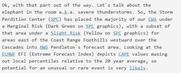
Good morning, neighbors! VERY EXCITING weather is on tap across the PNW today with the Storm Prediction Center (part of NOAA) calling for geographically abnormal thunderstorm, hail, lightning, and even tornado risk. It seems that NWS Portland is maybe mad at SPC; they called it the “Storm Perdition Center” this morning. Highest risks (and thus the most exciting weather) will be in the valley of Willies and north towards the Seattle-Tacoma metro area. Driving I-5 north this afternoon? Change your plans if you can! We too shall have some fun, but the golf-ball sized hail is likely to stay west of us. After today: just wet. A dry period is in the cards early Saturday through midday Sunday. Fingers crossed for our orchardist friends that it is dry enough for their needs.
Hindustani, the new Indian food restaurant
Before we talk about anything else… Hindustani, the Indian restaurant going in to the old China Gorge building, opens this Friday at 3pm. Hope to see you there!
glenwood
Checking in with Glenwood and today’s temp record potential: it must have been clear last night, because Glenwood is 40F this morning, about 10 degrees colder than the rest of us. Hood River is making an attempt at another record high-low; today’s record is 46, and the temp was 50 when I last looked. Hood River did set a record high of 75F yesterday. Today’s record is 74F.
today
On to today. If you haven’t read Shawn Weagle’s brilliant discussion of today’s thunderstorm potential (I posted it on TATAS on Facebook), please do so! This is where my self-taught meteorology skills don’t hold a candle to the folks with degrees. Speaking in lay-person language: all the factors are in place today for strong thunderstorms. We’ll have unseasonably warm temps, abundant moisture, southerly flow, rapidly decreasing temps with elevation, and wind from different directions at different elevations.
SPC has us – yes us – under a marginal risk for severe thunderstorms. West of us in the Valley of Willies and all the way north to Seattle, strong storms and large hail, up to the size of a golf ball, are likely. This is Mother Nature’s way of tormenting people who love golf and can’t play today: she throws thousands of golf-ball-like-objects from the sky. That’s very rare around here – there’s actually never been a Level II posted by SPC for our area. Anyway, I just asked AI, and it tells me that hail over 1” is capable of damaging a car. If you’re in the metro area, try and find a covered spot for your vehicle today. Or, if you’re like me and have a car that’s totaled already, consider driving to the metro area to add some additional character to your vehicle in the form of hundreds of dents.
Silliness aside, these storms could be quite dangerous and damaging. You’ll want to avoid driving around in them – even here in the Gorge, away from the strongest storms, we’re still likely to have hail of 1” size or less, torrential rain, abundant lightning, and strong wind gusts. Timing: after 2pm, probably. A bit later east of the Cascade crest. This probably goes without saying, but… this afternoon is not the time to be out hiking or in exposed areas.
thursday
Things stabilize overnight (sadly only in the weather, not in the country) and leave us with a very wet Thursday. Rain continues on-and-off to Arlington with intermittent showers in the SW/Sherman area. Temps max out in the upper 50s with mostly cloudy sky, rainbows, and light wind. Wind exceptions: 15-20mph easterlies at Stevenson/Iwash early with 15mph westerlies at Iwash later.
friday and beyond
Rain continues as far east as Rowena most of Friday with rain all the way to Arlington in the afternoon. High temp: 55F. Wind: calm the morning and evening. West 10-15 west of The Dalles and 15-25 east of The Dalles most of the day. Dry weather Saturday persists into Sunday morning before rain returns. Looking long-range, we’ve got on-and-off rain through the first week of April. After that? Who knows. I’ll be locked down in a silent meditation retreat for the entire month. I’ll see ya when I return. Enjoy the storms today. Safe travels. -TATAS
