


Thank you for using this forecast. Like it? Find it useful? Support it (and me!) by sending some cash my way. What’s it cost to support me and get the email version? Not $99 a year. Nope. Not $49. Just $19.99 or more gets you a year. Click below to contribute. Thank you!!
Click here to use your PayPal
Venmo: @theGorgeismyGym
Snail Mail: PO Box 841, Hood River, Oregon 97031
(note: I am not a non-profit entity. The only way to accept credit cards with a user-defined amount is to use the ‘donate’ button. Thanks for understanding!)
Auto-renewing subscription. New! Awesome!
The Forecast
| 4a-8a | 8a-12p | 12p-4p | 4p-8p | 8p-4a | |
|---|---|---|---|---|---|
| Wednesday 3500′->6500′->1500′ |
 |
 |
 |
|
 |
| Thursday 1500′->2000′ |
 |
|
|
|
 |
| Friday 2000′->5500′->4500′ |
 |
 |
|
|
|
Mt. Hood Weather Forecast
Active weather is still the general picture through the weekend, but the timing and intensity of the weather systems keeps changing. For example, on yesterday’s forecast, Thursday looked like a storm skiing day. Now it looks windy with light accumulation, rather than a full-on blizzard. And that could change again!Looking at Wednesday, we have a clear morning with snow, rain, and then snow again after mid-morning. The snow level will be 3500′ early, 6500′ in the afternoon, 4000′ in the evening, and 1500′ overnight. About 0.5” water equivalent falls by sunset. Call that snow (1”) and then rain (0.4”). Another 1.1” WE falls overnight. That’ll probably split as 0.6” rain and 0.5” WE as snow, for 3-4” new. Wind: WSW 15-20 in the morning. That builds to SW 30-60 this afternoon and turns to W 40 overnight.
Thursday brings orographic snowfall all day intermixed with sunshine above 5500′. The snow level will be 1500-2000′ all day. About 0.2” WE falls during the day, for 2-3” of dry snow. A traces falls overnight. Wind: W 40 in the morning, NW 40-45 in the afternoon, NW 20-25 after midnight.
Friday starts out dry and turns snowy, then possibly rainy, then snowy again. Sensing a pattern here?! The snow level will be 2000′ early, 5500′ in the evening, and 4500′ after midnight. About 0.1” falls during the day as snow, for an inch of new. Another 0.8” WE falls overnight. With 850mb temps at 2C, that’s likely to fall as a mix of rain and snow, possibly transitioning back to snow overnight. Even if we do see a transition, rain is in the forecast for Saturday, so it won’t make much difference! Wind Friday: NW 20-25 early, WSW 30-45 in the afternoon, W 50 (affecting lifts) in the evening, and W 40 after midnight.
As of this morning, we’re looking at a forecast of light rain on Saturday and pouring rain Sunday.
Gorge Wind Forecast
Light and variable wind Wednesday morning picks up to E 20-25 in the afternoon from Rooster to Viento. The wind turns westerly overnight. Thursday brings westerlies at 23-26 west of Hood River and east of Bingen early. The wind quickly fills in to gusty 23-26 from Stevenson to The Dalles with 28-32 in the eastern Gorge. Peak wind: 10am to 1pm, most likely. Friday: light and variable. River flow Wednesday: 142kcfs. River temp: 44. Air temp: 41.Coast, Jones, Sauvie’s
As needed until next spring and summer.Hood River Weather Forecast
A cloudy morning turns rainy after 10am or so and stays that way. Temps will be in the mid 40’s all day. Light and variable wind in the morning turns easterly in the afternoon and westerly overnight. 11% chance of rainbows. Thursday will be showery in the morning and mostly cloudy during the day. Temps will be in the low 40’s early and mid 40’s later. Moderate to strong westerlies. 99% chance of rainbows. The first half of Friday looks dry, but the second half will be wet. Temps will be in the upper 30’s early and mid 40’s later. Light and variable wind. No rainbows. Looking for a complete Columbia Gorge forecast? Looking for more humor in your weather? Obscenities? You’re looking for my TATAS: Temira’s Awesome Travel Advisory Service on Facebook.Cycling
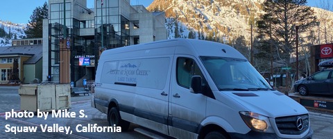
Volunteers needed! Columbia Area Mountain Bike Advocate (CAMBA) is doing small projects at the Syncline this winter: treadwork and trail maintenance. Show that we care and want to protect it! Due to COVID restrictions, work party numbers are limited, so if you can help, contact Ann 509-637-3713. Hikers, runners, mountain bikers, and sightseers all welcome! Do be aware of the possibility of freeze-thaw (muddy) conditions, especially on trails that are not under a tree canopy. Do not ride if it was below freezing last night and is above freezing when you want to ride. The soil structure will be liquefied, and you will do permanent damage to trails. Consider riding gravel roads instead.Sprinter Van of the Week!
 Click here for the Sprinter Van map of the world!!!
