

MT HOOD SNOW FORECAST

Hey skiers and snowboarders! Winter still isn’t, but ski season still is – Meadows and Timberline are holding it together, and Meadows has a little Nordic loop in the base area for you skate skiers and Nordic ski students. A weather system swings through today (Wednesday) and brings a little bit of very welcome snow to the slopes. After a cool day Thursday, warmer weather is forecast Friday. Uncertainty about temps and cloud cover remains high for the weekend and into the deeper future.
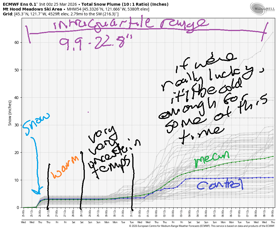
Short term Mt Hood snow forecast
Wednesday starts off partly cloudy. Snow arrives mid-morning and lingers until sunset. Overnight: clear sky. The snow level will be 2500′ early, 3500′ in the afternoon, and the freezing level will drop to 0-1000′ overnight. During the day, we’re expecting 0.2” to 0.3” water equivalent (WE) of snow for 2-3” new. Another 0.1” to 0.2” WE falls after 5pm for an inch or two more. Wind will be WSW 25 until early afternoon, and then it rises to WNW 35-40 in the evening before dropping to WNW 15-20 overnight. Snow conditions today will start as icy frozen granular (there was about 0.8” rain yesterday, and the snowpack refroze overnight) and add some fresh atop it this afternoon.
Thursday will be sunny. The free air freezing level (FAF) will be 0-1000′ in the morning, 2500′ in the afternoon, and 6500′ overnight. Temps at 5000′ rise to 32F in the afternoon. Wind will be WNW 15-20 early becoming light and variable from mid-afternoon on through the night.
Extended Mt Hood Snow Forecast
Sunny weather starts Friday, and high clouds finish it. The FAF will be 6500′ early, 10,000′ in the afternoon, and 9000′ overnight. Temps at 5000′ rise to the low 40s in the afternoon. Wind will be light and variable all day becoming W 10 overnight.
Uncertainty rises for the weekend. Temps are likely to remain above 32F, but it’s unclear just how warm it will be. For now, let’s call sky coverage “intermittently cloudy” – there’s a lot of disagreement in the models. Precipitation seems unlikely. Somewhat cooler weather returns by the early or middle part of next week, but snowfall seems unlikely. Looking at the intraquartile range for snowfall through April 9th, we have 9.9-22.8”. Better than nothin’, and it’ll be awesome to get a few inches of snow today!
Was that helpful? I knew it was! Guess what? All of this crucial work – from your personal wind and snow reports to the invaluable TATAS updates – is made possible by my relentless efforts. Maintaining this labor of love isn’t easy. Each daily forecast takes hours. Website hosting, weather model access, and back-end admin work takes time and money. That’s where you come in.
YOUR CONTRIBUTION MAKES A DIFFERENCE
- SUPPORT ACCURATE, HYPER-LOCAL WEATHER FORECASTING
- ENABLE ACCESS FOR ALL, EVEN THOSE WITH LESS MEANS
- SUPPORT A COOL HUMAN WHO WORKS HARD SO YOU CAN PLAY
Take a moment to click one of the buttons below. Donate $19.99 or more (how much does this forecast enhance your life?) and get the email in your inbox. Whether it’s a renewing subscription (auto-renew) or a one-time donation, every contribution makes a real difference. Help me keep this labor of love alive, so we can all continue playing, commuting, and living in the Gorge with peace of mind and the best weather forecasts possible. Thank you!


Hood River, Oregon 97031


GORGE WIND FORECAST
If you’re still seeing yesterday’s and it’s after 9am, try opening this in an incognito window
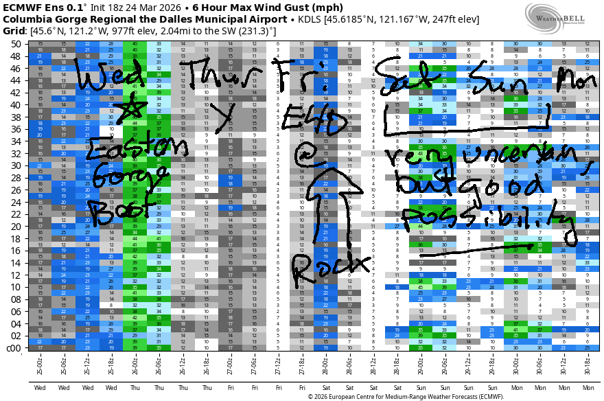
SHORT-TERM gorge wind forecast
Hey friends! A decent day is shaping up today as a cold front swings through and high pressure builds offshore. Next best chance for wind is Friday, when 40mph east wind is forecast at Iwash (Rooster) Rock. Unusually high uncertainty remains in the models for the weekend, but there’s a decent chance of moderate westerlies both days.
Wednesday starts with pressures of 30.09/30.01/29.99 for gradients of 0.08/0.02. Rain is incoming for the west side, but dry weather will persist out east. You know where to go! East! Prior to the rain, we’ll have gusty 20-25mph at Viento with gusty 14-17 at the Hatch. Lighter wind is slated for the morning from Mosier to Doug’s, and you’ll find gusty 15-18mph out east. Let the cold front swing through. By mid-afternoon, westerlies build to gusty 19-22* from Stevenson to Hood River with 29-33 from Lyle to Arlington. Evening wind spreads all the way to Boardman. After 5pm, areas between Stevenson and Hood River drop to 13-16mph.
* – While models suggest 19-22mph from Stevenson to Hood River post-frontal, a 60-90 minute period of stronger wind is entirely possible – models often don’t catch the post-frontal Hatch blast. River flow over the last 24 hours was 235-262kcfs, river temp is 46.2F, and high temp forecast is 54F in Hood River and 60F out in the desert. General consensus is that 200kcfs is max for paddling near Rufus, and 300-325kcfs is max for wind-powered sports.
RIVER FLOW FOR SITES BETWEEN AVERY (EAST OF THE DALLES) AND RUFUS: CLICK HERE FOR JOHN DAY DAM FLOW.
RIVER FLOW FOR SITES BETWEEN STEVENSON AND DOUG’S BEACH (WEST OF THE DALLES): CLICK HERE FOR THE DALLES DAM FLOW

LONGER-TERM gorge wind forecast
High pressure builds inland on Thursday. The wind takes a break. We’ll see very light westerlies or calm conditions early. Midday wind rises to E 15mph at Stevenson and W 5-10mph at Iwash (Rooster) Rock. High temp: 55F wish sunshine.
On Friday, a heat low of sorts sets up in the Willamette Valley, and cooler air lingers for at least part of the day in the desert. Easterlies are forecast at 40-45mph near Iwash Rock and 30mph near Stevenson until late morning or perhaps early afternoon. After 2pm, the wind settles in at 20mph at Iwash and 15mph at Stevenson. High temp: 60F with increasing clouds.
Ensembles for Saturday and Sunday contain very high levels of uncertainty. As a matter of fact, there’s so much uncertainty that I can’t even tell you if we’re looking at east wind or west wind. I’ll hold off on guessing until clarity develops in those ensembles. In the meantime… have a great day on the Nch’i Wana today!

BARE BONES HOOD RIVER WEATHER FORECAST
Partly cloudy this morning with drizzle in the afternoon. Temps start in the upper 40s and rise to the mid 50s. Moderate westerlies. 99% chance of rainbows. Thursday will be partly cloudy then clear. Temps start in the mid 30s and rise to the mid 50s. Light and variable wind. No rainbows. Friday will be mostly clear then mostly cloudy. Temps start in the mid 30s and rise to 60 or so. Light easterlies. No rainbows.
TEMIRA’S AWESOME TRAVEL ADVISORY SERVICE
HYPERLOCAL WEATHER FORECAST FOR THE COLUMBIA GORGE
THE DALLES, HOOD RIVER, WHITE SALMON, TROUT LAKE, STEVENSON, CASCADE LOCKS, PARKDALE, ODELL, HUSUM, BZ, MILL A, WILLARD, GOLDENDALE, RUFUS, ARLINGTON, boardman
Good morning, neighbors! TATAS got distracted this morning looking at plans for a DIY hip trust bench. That’s because TATAS doesn’t have much to contribute to a weather forecast when the weather is being un-Gorge-like. Other than a bit of rain and wind today, mild, unassuming weather is forecast for the extended period. Biggest news: a chance of frost Thursday and Friday mornings.
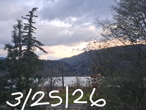
Glenwood this morning
The closest we have to frost this morning is in the Dufur area where temps are reading 32-37F on the inexplicably numerous thermometers there. Drive up past Parkdale on Highway 35, and you’re likely to encounter some ice thanks to radiational cooling. Glenwood is way out of the medals this morning with a low temp of 39F.
Today’s Gorge weather forecast
After a cloudy (west) and sunny (east) start, a weather system takes over mid-morning. This brings drizzle to Cascade Locks by noon, Wishram by 2pm, and South Wasco (just a touch of rain) by 5pm. Rain wraps up for all by 8pm. In the middle of all this, west wind picks up: 20-25mph west of Mosier and 25-35mph from Mosier to Boardman. High temps rise to the low 50s (west), upper 50s (The Dalles) and low 60s (the Desert).
Thursday’s Gorge weather forecast
Overnight, the wind stops, the sky (mostly) clears, and dewpoints fall to the 28-31F range. With temps at 850mb at -7C on Thursday morning, we could see frost all the way down to river level. Road temps are pretty warm, but we can’t rule out some black ice or frost Thursday morning. By afternoon, temps rise to 55-57F under sunny sky. Wind: light and variable becoming E 10-15mph near Stevenson.
Extended Gorge weather forecast
Friday starts mostly clear with a few high clouds, perhaps enough for a colorful sunrise. Despite warmer temps aloft, Friday morning is likely to be colder than Thursday morning thanks to much lower humidity. Expect frost all the way down to river level with temps in the 26-30 range near Parkdale, Trout Lake, Goldendale, and Dufur. During the day, areas west of The Dalles turn fully cloudy. East of The Dalles: partly cloudy. High temps top out at 60-63F. Commuters: expect east wind at 40mph near Iwash (dick) Rock in the morning and 20mph in the afternoon. Stevenson: 30mph fading to 15mph.
Looking at the weekend, we have unusually high levels of uncertainty about temps and wind and cloud cover. Precipitation is unlikely. Frost is unlikely. On Saturday, there are giant demonstrations against democratic backsliding, bigotry, and war all across the Gorge. Do join in for a rousing collaboration with your neighbors. Protesting, unfortunately, won’t increase your bank balance, but it might give you a sense of agency and connection. Visit the NoKings website for the times and locations of all the local protests. Keep standing up for democracy, kindness, and equality, peeps. I’m proud of you! Safe travels. -TATAS
HEY! DON’T STOP READING! Is this community-focused forecast helpful to you? It sure is! It takes me a couple hours a day to write. Please join your friends and neighbors in contributing to keep it going. Venmo: @thegorgeismygym PayPal: twomirrors@gmail.com USPS: Temira / PO Box 841 / Hood River, Oregon 97031 You can test out the forecast subscription for a few days for free by signing up below. Easy! Do it!
JONES BEACH, SAUVIE ISLAND, & COAST FORECAST
ON WINTER VACATION UNLESS DESPERATELY NEEDED.

Leave a Reply