

MT HOOD SNOW FORECAST

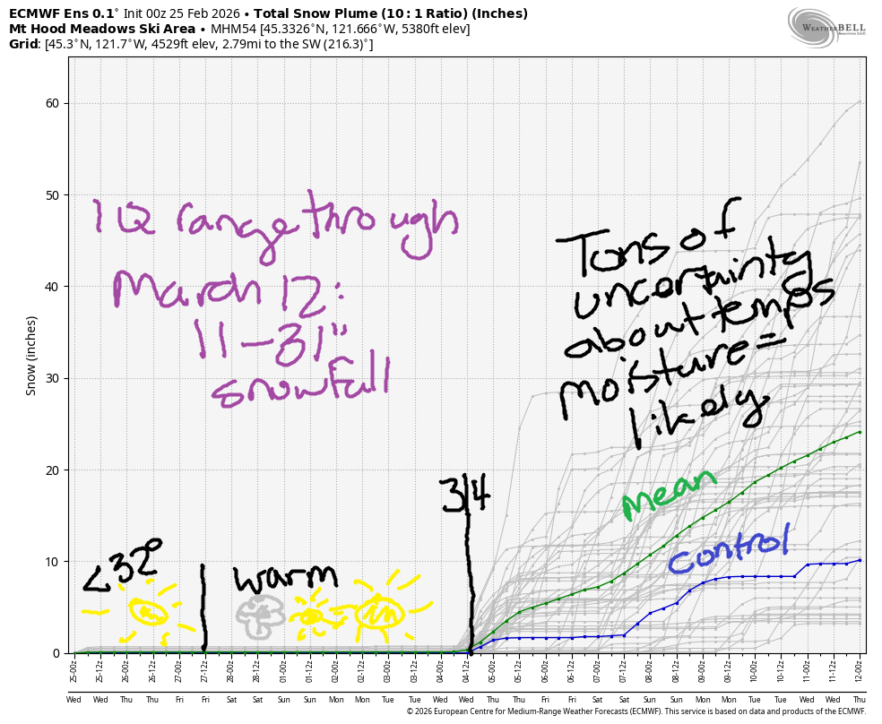
Hey skiers and snowboarders! Thank goodness we picked up a couple of feet of snow this week at the higher ski resorts, because we’re headed for another week of dry weather. I just went down the historical database rabbit-hole. Our snowpack is currently at 39% of normal and stands at the 7th percentile.
We’re in the company of these years: 2015 (when I rode my bike over Vista Ridge – 4000′ – in March), 2005 (almost as bad as 2015, which was the driest of all), 1981 (it recovered a bit), and 2003 (came close to average at the end). Of note with ’03 and ’81 is that it stayed cold and kept snowing into May, something we haven’t seen in the last 5 years or more. Anyway… Models keep us dry until March 4th or so, and then they offer up precipitation but no certainty around temps.
Short term Mt Hood snow forecast
For the next few days, we’ll stay cool. Today is Wednesday, and this forecast is for today and tomorrow; I have much sh*t to do and need those two hours back! Wednesday will be sunny on the mountain and quite windy to start; with a forecast of NW 25+, some lifts could see impacts early. The free air freezing level will be 1000′ early, 2500′ in the afternoon, and below 1000′ tonight. Temps max out in the upper 20s at 5000′ today. Wind will be NW 25-35mph early, NW 15-20 in the afternoon, and WNW 15-20 overnight. Snow surface today is reportedly “hard and fast with breakable crust off the groom”, meaning that the last precip type was likely rain or wet snow that’s now frozen hard. Hopefully that moisture content will allow for a faster transition to corn when things warm up on Friday!
Thursday will be sunny all day. The free air freezing level (FAF) starts around 500′, rises to 6500′, and drops back below 1000′ overnight. Temps max out in the upper 30s. Wind will be WNW 15-20 in the morning, W 25 in the afternoon, and WNW 20-25 overnight. No major concerns here other than remembering to rub on some sunscreen!
Extended Mt Hood Snow Forecast
Sunshine continues all day Friday, and temps will be on the rise. The free air freezing level starts below 1000′ and rises to 8500′ in the afternoon with temps in the low 40s at 5000′. Wind will be WNW 20-30 early, WNW 10-15 in the afternoon, and NE 10 overnight. Again, no concerns. Enjoy the sun!
Saturday starts clear but adds high clouds as a system pushes inland to the south. Overnight, clear sky returns. We’re almost certain to stay dry. The free air freezing level hovers around 9000′ all day and drops to 7000′ after midnight. Wind will be variable to 10mph all day. Sunshine returns on Sunday with the freezing level around 7000′ and temps in the upper 30s with light wind. Sunny weather sticks around to start next week. Uncertainty increases midweek. Please vote for snow!
Was that helpful? I knew it was! Guess what? All of this crucial work – from your personal wind and snow reports to the invaluable TATAS updates – is made possible by my relentless efforts. Maintaining this labor of love isn’t easy. Each daily forecast takes hours. Website hosting, weather model access, and back-end admin work takes time and money. That’s where you come in.
YOUR CONTRIBUTION MAKES A DIFFERENCE
- SUPPORT ACCURATE, HYPER-LOCAL WEATHER FORECASTING
- ENABLE ACCESS FOR ALL, EVEN THOSE WITH LESS MEANS
- SUPPORT A COOL HUMAN WHO WORKS HARD SO YOU CAN PLAY
Take a moment to click one of the buttons below. Donate $19.99 or more (how much does this forecast enhance your life?) and get the email in your inbox. Whether it’s a renewing subscription (auto-renew) or a one-time donation, every contribution makes a real difference. Help me keep this labor of love alive, so we can all continue playing, commuting, and living in the Gorge with peace of mind and the best weather forecasts possible. Thank you!


Hood River, Oregon 97031


GORGE WIND FORECAST
If you’re still seeing yesterday’s and it’s after 9am, try opening this in an incognito window
SHORT-TERM gorge wind forecast
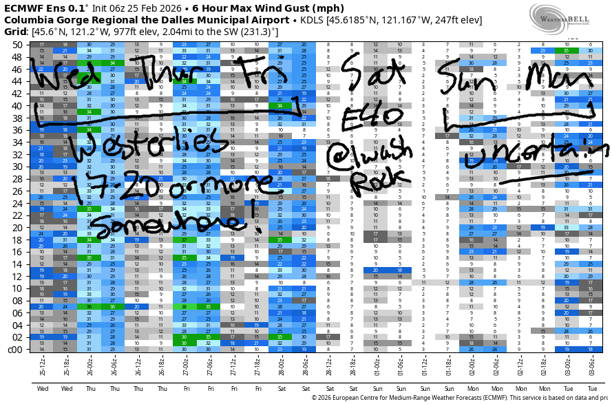
Hi friends! I was looking back through my Strava records from last year, and it appears I was paddling at Rufus on a day in early March. That puts this week’s weather squarely in “normal” for getting on the river. If you’re headed out, be careful – the river is still very cold! We are looking at a few days of potentially just-enough west wind for your favorite foil sports. We’ll be back to easterlies on Saturday. By Sunday, we’ll be wallowing in uncertainty as high pressure lingers; models are currently uncertain which way the wind will blow. Heads up: I don’t plan to do a full forecast on Thursday – I’m really short on time, but I’ll drop a quick wind forecast update on the website.
Wednesday will be a west wind day. Pressures prior to dawn were 30.11/30.02/29.99 for 0.09/0.03 onshore gradient. Models give us partly cloudy sky in Hood River in the morning and mostly clear sky in the afternoon with sunshine out east all day. Looking at the early speeds, we had 25mph at Viento, 17-20mph at the Hatch and Rufus, and 14-17mph at Rowena and Arlington. Models give us 17-20ish from Viento to Hood River, perhaps to Mosier, this morning. Afternoon wind drops to 14-17mph and fills in from Stevenson to Hood River with 19-22mph from Lyle to Avery. Rufus ends the day with 14-17mph. East of there: less wind. River flow over the last 24 hours was 178-193kcfs (184-193kcfs at Rufus), river temp is 41.5F, and high temp forecast is 46F with afternoon sunshine.
RIVER FLOW FOR SITES BETWEEN AVERY (EAST OF THE DALLES) AND RUFUS: CLICK HERE FOR JOHN DAY DAM FLOW.
RIVER FLOW FOR SITES BETWEEN STEVENSON AND DOUG’S BEACH (WEST OF THE DALLES): CLICK HERE FOR THE DALLES DAM FLOW

LONGER-TERM gorge wind forecast
Thursday starts with light westerlies thanks to chilly (low to mid 30s) temps across the region. By mid-morning, westerlies build to 13-16mph from Stevenson to the Hatch and also from Avery to Arlington with less wind between Hood River and Doug’s. Models suggest a period of 18-21mph late morning into early afternoon for Stevenson-Mosier and Avery-Rufus before the wind drops to 14-17mph all through the Gorge late afternoon. High temp: 51F with mostly clear sky.
Friday stars with 20-23mph from Viento to the Hatchery and falls to 14-17mph after 11am. Areas east of Mosier will see less than 15mph, probably less than 10mph, all day long. High temp: 53F with partly cloudy sky to start in Hood River and sunny sky to finish. On Saturday, the wind switches direction: we’ll have easterlies at 40mph at Iwash Rock in the morning before a precipitous afternoon collapse of wind speeds. Models are uncertain what we’ll see on Sunday and Monday. Stay safe and warm out there. Keep an eye on your buddies!
BARE BONES HOOD RIVER WEATHER FORECAST
Partly cloudy this morning. Mostly clear this afternoon. Temps start in the upper 30s and rise to the mid 40s. Moderate westerlies. 0.5% chance of rainbows. Thursday will be mostly clear then clear. Temps start in the low-mid 30s and rise to the low 50s. Moderate westerlies. No rainbows. Friday will be partly cloudy then mostly clear. Temps start in the mid 30s and rise to the low 50s. Moderate westerlies. No rainbows.
TEMIRA’S AWESOME TRAVEL ADVISORY SERVICE
HYPERLOCAL WEATHER FORECAST FOR THE COLUMBIA GORGE
THE DALLES, HOOD RIVER, WHITE SALMON, TROUT LAKE, STEVENSON, CASCADE LOCKS, PARKDALE, ODELL, HUSUM, BZ, MILL A, WILLARD, GOLDENDALE, RUFUS, ARLINGTON, boardman

Good morning, neighbors! A string of pleasant days are on tap. If you’re hoping for winter, it’s not what you’re hoping for. If you’re ready for a sunny, 60 degree day, a couple are scheduled for you next Monday and Tuesday. Between now and then, the only day with a high temp under 50F is today, and the only cloudy day will be Saturday. All-in-all… pleasant! Good for commuting! Good for gardening! Good for hiking and biking and riding-your-triking!
Glenwood this morning
To start off Wednesday, we have sub-freezing temps near Dufur, Goldendale, upper elevations of Mosier and The Dalles, Trout Lake, and of course Glenwood, where everyone’s looking smug with a winning low temp of 29F. Watch out for icy roads this morning – the combo of clear sky, cool temps (under 36F), and light wind away from the river could allow radiational cooling to freeze some spots. Nobody has confirmed icy roads this morning, and nobody has confirmed the presence of !CE (thankfully). If you want to get trained as an !CE verifier, reach out. There’s a training coming up in March!
Today’s Gorge weather forecast
There’s not all that much to say about the weather for the next five days or so. This means I’m going to take tomorrow off, because otherwise I’m not going to get the shit done that I need to get done. Generally speaking, the weather will be dry and increasingly warm, with the “heat” peaking at or above 60F in The Dalles next Tuesday.
Wednesday, this Wednesday, the day known as “today”, will be partly cloudy west of Mosier to start with sun all day to the east. West of Hood River, the day ends mostly clear with temps in the upper 40s all the way east to The Dalles. In the desert, you might break the 50 degree threshold. West wind is forecast today: 15-20mph all day from Rufus westward with 15mph east of Rufus to Hermiston.
Thursday’s Gorge weather forecast
Overnight into Thursday, temps are likely to drop near freezing all across the Gorge thanks to mostly clear sky and light wind. Away from the Big River (Nch’i Wana / Columbia), temps will drop into the mid-20s with colder weather possible in Glenwood. Icy spots are possible on the roads. Heading into the afternoon, temps rise a degree or two above 50, and west wind picks up to 20mph from Stevenson to Rufus with 15-20mph east of Rufus to the Arlington Triangle and the Hermiston Hexagon.
Extended Gorge weather forecaast
Friday looks similar – partly cloudy in the west early with sunshine to the east all day. Sunny everywhere in the afternoon. West wind at 15-20mph. High temps in the low 50s. Saturday temps look the same, but we’ll have east wind at 40mph near Iwash and high clouds in the afternoon all across the Gorge. Sunshine returns on Sunday, and temps climb a degree or two or three each day. We’ll max out near 60F on Monday and Tuesday. Starting Wednesday, cooler weather is likely, but the details are unclear. Let’s leave it there for now. Safe travels. -TATAS
HEY! DON’T STOP READING! Is this community-focused forecast helpful to you? It sure is! It takes me a couple hours a day to write. Please join your friends and neighbors in contributing to keep it going. Venmo: @thegorgeismygym PayPal: twomirrors@gmail.com USPS: Temira / PO Box 841 / Hood River, Oregon 97031 You can test out the forecast subscription for a few days for free by signing up below. Easy! Do it!
JONES BEACH, SAUVIE ISLAND, & COAST FORECAST
ON WINTER VACATION UNLESS DESPERATELY NEEDED.
