

MT HOOD SNOW FORECAST

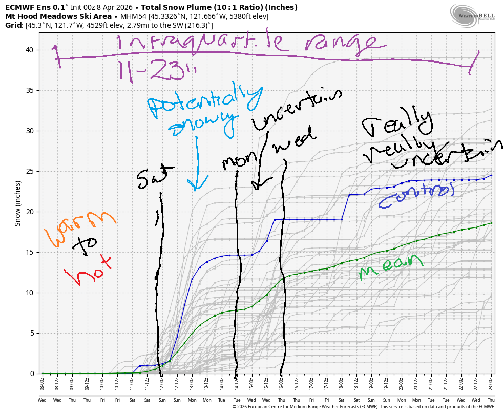
Hey skiers and snowboarders! Mostly sunny, warm weather continues on Mt Hood through Friday. For the weekend, we’ll have cooler weather with intermittent clouds and a chance of a little drizzle. Cooler weather continues through the early part of next week when a little snow is possible. The intraquartile range through April 23rd has jumped to 11-23”. Too late to save ski season, but a nice addition to the snowpack if it happens.
Short term Mt Hood snow forecast
Wednesday starts off clear with temps in the upper 30s at 5000′. Some high clouds move in later. Despite the early above-freezing temps, the snow did refreeze overnight, so there should be good corn snow for you after a hard/fast granular start. The free air freezing level (FAF) hovers around 9000′ today with west wind at 10-15mph. Temps at 5000′ max out in the low 40s.
Sunshine sticks around all day Thursday. The FAF will be 9000′ all day and 10,000 overnight with max temps at 5000′ around 50F. Wind will be light/variable all day long. Friday brings intermittent high clouds. The FAF will be 10,000′ early and will fall to 7000′ overnight with increasing clouds. Temps max out in the low to mid 40s. Wind will be variable to 15 becoming NW 10-15 after midnight.
Extended Mt Hood Snow Forecast
On Saturday, a little rain is possible during the day with clear sky for a period in the evening before clouds return overnight. The snow level will be 6500-7000′ all day and 6000′ overnight. Sometimes in spring, thanks to the lapse rate, we can see snow at 40+ degrees. So, snowflakes aren’t out of the question. Accumulating snow probably is – there’s no more than 0.2” water equivalent forecast, and we probably wont’ see that much. Wind will be variable to 10 becoming W 15 overnight. Temps max out near 40F.
Cooling is forecast on Sunday with the snow level around 6000′ early, 5000′ in the afternoon, and 3000′ overnight. We’re unlikely to see any snow accumulation. Wind will rise from W 15 in the morning to WNW 30-35 in the afternoon and hold overnight. As we look deeper into the future, we see a decent chance for at least a little snow next week as cooler temps combine with incoming moisture. We’ll see how this shakes out as we get closer… See you on the snow soon!
Was that helpful? I knew it was! Guess what? All of this crucial work – from your personal wind and snow reports to the invaluable TATAS updates – is made possible by my relentless efforts. Maintaining this labor of love isn’t easy. Each daily forecast takes hours. Website hosting, weather model access, and back-end admin work takes time and money. That’s where you come in.
YOUR CONTRIBUTION MAKES A DIFFERENCE
- SUPPORT ACCURATE, HYPER-LOCAL WEATHER FORECASTING
- ENABLE ACCESS FOR ALL, EVEN THOSE WITH LESS MEANS
- SUPPORT A COOL HUMAN WHO WORKS HARD SO YOU CAN PLAY
Take a moment to click one of the buttons below. Donate $19.99 or more (how much does this forecast enhance your life?) and get the email in your inbox. Whether it’s a renewing subscription (auto-renew) or a one-time donation, every contribution makes a real difference. Help me keep this labor of love alive, so we can all continue playing, commuting, and living in the Gorge with peace of mind and the best weather forecasts possible. Thank you!


Hood River, Oregon 97031


GORGE WIND FORECAST
If you’re still seeing yesterday’s and it’s after 9am, try opening this in an incognito window
SHORT-TERM gorge wind forecast
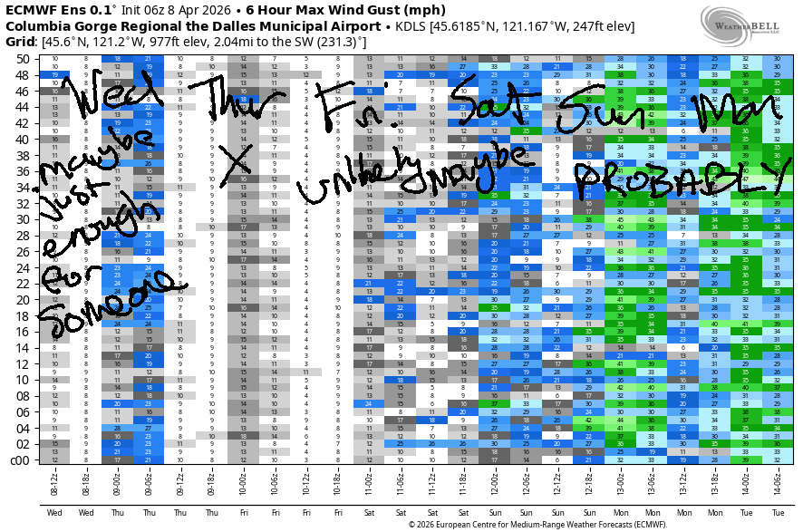
Hi friends! Yesterday ended up being a very weird day after a very promising start. Not much wind is forecast for the next few days. It’s possible we’ll have enough for a few folks today (Wednesday) and Friday and Saturday. Better chances for stronger westerlies are in the models for Sunday and Monday, but that’s a long ways out to be making plans as things are likely to change!
Wednesday started with pressures of 30.09/30.05/30.05 for gradients of 0.04/0.00. Westerlies were light to start. They’ll rise to 11-14mph from Stevenson to Doug’s late morning and to 13-16mph from Stevenson to Avery after 2pm. River flow over the last 24 hours was 164-209kcfs, river temp is 48.2F, and high temp forecast is 68F under mostly clear sky.
RIVER FLOW FOR SITES BETWEEN AVERY (EAST OF THE DALLES) AND RUFUS: CLICK HERE FOR JOHN DAY DAM FLOW.
RIVER FLOW FOR SITES BETWEEN STEVENSON AND DOUG’S BEACH (WEST OF THE DALLES): CLICK HERE FOR THE DALLES DAM FLOW

LONGER-TERM gorge wind forecast
Thursday will be calm to start, E 10mph near Stevenson midday, and calm to finish. High temp: 72F with mostly clear sky and a few high clouds.
There’s a slightly better chance for wind on Friday as a weak system swings through. The day starts dead calm. Midday westerlies rise to 12-15mph from Stevenson to the Hatch with 7-10mph from Hood river to Mosier. In the afternoon, we’ll have gusty, up-and-down 15-18mph from Stevenson to Doug’s with light/variable conditions east of The Dalles As the system swings through late afternoon (timing subject to change), there could be a period of very gusty 17-21mph from Lyle to Rufus. High temp: 72F with intermittent clouds.
A system moving up the coast on Saturday gives us the possibility of gusty 19-22mph in the Corridor, but gusty is the operative word – instability is likely. The overall setup improves (probably – subject to change!) on Sunday and Monday giving us the possibility of much stronger westerlies that would likely focus on the eastern Gorge. We’ll keep a close eye on all this! See you on the Nch’i Wana soon!

BARE BONES HOOD RIVER WEATHER FORECAST
Partly high overcast sky (pretty sunrise!) this morning and clear sky later. Temps start in the mid 30s and rise to the upper 60s. Light to moderate westerlies. No rainbows. Thursday will be mostly clear then partly high clouds. Temps start in the low 40s and rise to the low 70s. Light/variable wind that will be dead calm in the morning and afternoon. No rainbows. Friday will be partly cloudy then mostly clear. Temps start in the upper 40s and rise to the low 70s. Calm wind early. Moderate westerlies later. No rainbows.
TEMIRA’S AWESOME TRAVEL ADVISORY SERVICE
HYPERLOCAL WEATHER FORECAST FOR THE COLUMBIA GORGE
THE DALLES, HOOD RIVER, WHITE SALMON, TROUT LAKE, STEVENSON, CASCADE LOCKS, PARKDALE, ODELL, HUSUM, BZ, MILL A, WILLARD, GOLDENDALE, RUFUS, ARLINGTON, boardman
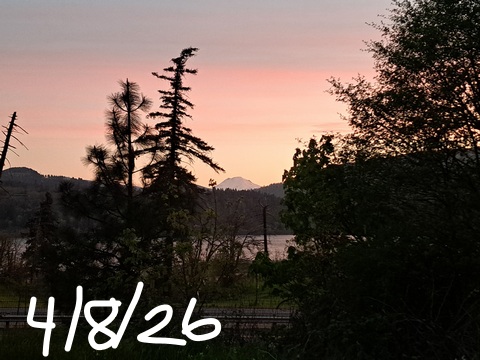
Good morning, neighbors! Beautiful sunrise this morning! Actually, every morning the sun comes up is a good morning – it could potentially go supernova at any time (NOBODY IS SUGGESTING THIS IS IMMINENT!), so it’s good to be grateful the sun is still here. Know what else is awesome? The fact that no nukes were deployed last night and no civilization was obliterated.
Today’s Gorge weather forecast
While this is something to cheer along with today’s 68-70F, sunny, west wind 10-15mph weather, the no-obliteration outcome shouldn’t bring a sense of relief. That build-up can be considered a test of our system, and our system failed. Nobody stepped in when threats of genocide were made. There was not a clear statement by the masses of elected officials about the wrongness of such threats. Some of the failure lies with government, and some with us, The People – we (and that includes ME) did not take to the streets by the millions to say “NO” loudly and clearly. Checks and balances have failed, and the world is worried. You should be too. See you on the streets.
Glenwood this morning
(PS Glenwood was 28F this morning, and nobody’s see any ice or !CE)
Thursday’s Gorge weather forecast
Tomorrow’s weather starts out with low 40s. While Glenwood could see 30-33F for the low, everyone else should be at least a couple degrees above 32F. Highs will be 72-73F. Wind will be calm all day except near Stevenson where it’ll rise to E 10mph midday before turning clam again.
Friday’s Gorge weather forecast
Friday adds some clouds thanks to a system moving up the coast. It’s unlikely to add rain. After a 48F start in the lowlands (no frost anywhere), temps rise to 72-75F, warmest in the desert. Calm wind early rises to 15-20mph from Stevenson to The Dalles in the afternoon with 15-20mph near Rufus in the evening.
Extended Gorge weather forecast
The weekend and next Monday look cloudy and cooler (low 60s max from The Dalles westward) with stronger westerlies. A few sprinkles or a little drizzle cant’ be ruled out on Saturday. Next week looks cooler with some rain possible. Okie dokie. I have a hard out this morning with a 7:30am appointment, so I gotta run. Safe travels. -TATAS
HEY! DON’T STOP READING! Is this community-focused forecast helpful to you? It sure is! It takes me a couple hours a day to write. Please join your friends and neighbors in contributing to keep it going. Venmo: @thegorgeismygym PayPal: twomirrors@gmail.com USPS: Temira / PO Box 841 / Hood River, Oregon 97031 You can test out the forecast subscription for a few days for free by signing up below. Easy! Do it!
JONES BEACH, SAUVIE ISLAND, & COAST FORECAST
ON WINTER VACATION UNLESS DESPERATELY NEEDED.

Leave a Reply