

GORGE WIND FORECAST
If you’re still seeing yesterday’s and it’s after 9am, try opening this in an incognito window
today’s gorge wind forecast
Hi friends! All sorts of weather systems are planned for the Gorge for the next five days, and that’ll lead to a few periods of gusty west wind. Best chance for stronger wind remains Saturday night, but models still have that wind blowing through after dark. Other things to do in lieu of wind sports: the dirt is perfect for mountain biking right now. There’s an HRATS trailwork party on Sunday: meet at Family Man at 9am. Maybe, just maybe we’ll have some earn-your-turns on Sunday or Monday up in the mountains…
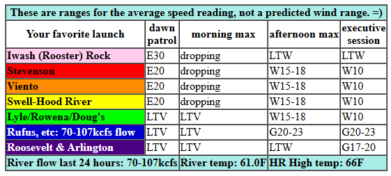
It’s Wednesday morning, and I think I’ll take tomorrow off. Not much to see here! Today kicks off with pre-dawn easterlies blowing 30mph at Iwash (Rooster) Rock, 15mph at Stevenson, and 23mph at Viento. Easterlies hang in for a few hours before shutting off midday. Ahead of an approaching cold front, westerlies return this afternoon. We’ll have gusty 15-18mph from Stevenson to Hood River by early afternoon. Mid-afternoon brings gusty 15-18mph from Stevenson to Doug’s with gusty 20-23mph from Avery to Rufus. Arlington eventually picks up to gusty 17-20mph after 5pm, and in that same time period, areas west of The Dalles drop below 10mph. River flow over the last 24 hours was 70-107kcfs, river temp is 61.0F, and high temp forecast is 66F for Hood River.
RIVER FLOW FOR SITES BETWEEN AVERY (EAST OF THE DALLES) AND RUFUS: CLICK HERE FOR JOHN DAY DAM FLOW.
RIVER FLOW FOR SITES BETWEEN STEVENSON AND DOUG’S BEACH (WEST OF THE DALLES): CLICK HERE FOR THE DALLES DAM FLOW

tomorrow’s gorge wind forecast
Thursday starts with light west wind, under 10mph, and probably just near Hood River. The wind quickly turns calm and stays that way. High temp: 65F with clouds all day long and a little morning drizzle.
extended Gorge wind forecast
Friday’s going to be a very wet day. You might catch a brief period of 17-20mph from The Dalles to Arlington ahead of the incoming rain. Other than that, the models have light wind in the morning and light wind in the afternoon all through the Gorge. High temp: 62F in Hood River and 65F east of The Dalles.
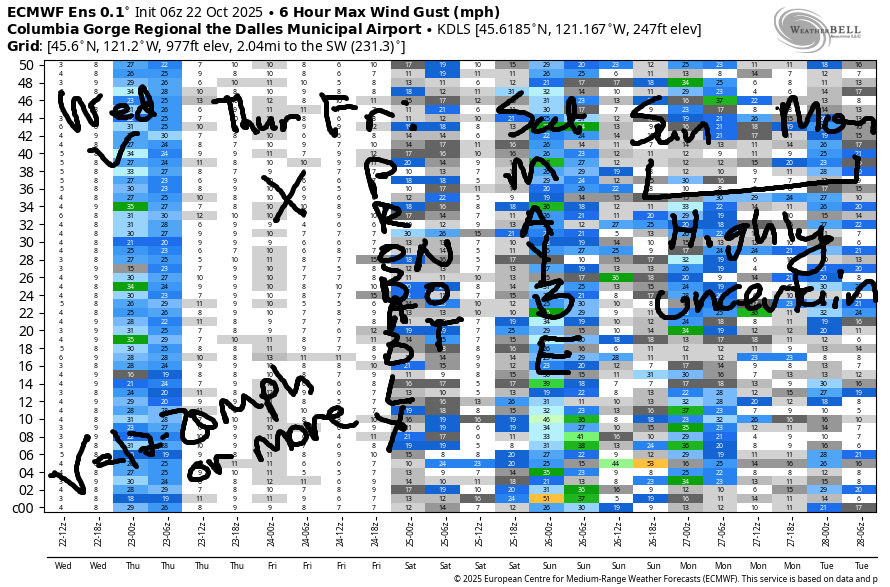
A strong low pressure system spins offshore on Saturday and keeps the wind from doing much. Some ensemble members swing that low or an associated cold front inland Saturday night and accompany it with very strong west wind. Key part of that: overnight. Models currently have all the wind in the dark. Lingering westerlies are possible Sunday morning, but they’ll die off quickly. In that Saturday-Sunday period, a LOT of rain is forecast as well along with high temps in the low to mid 50s. It’s definitely not an ideal setup for the Gorge, and it’s unlikely to play out in our favor. However… lots of snow will be falling in the mountains, and lots of rain will be swelling the rivers, so maybe you can make some fun out of one of those two things! Have an awesome day today!
Was that helpful? I knew it was! Guess what? All of this crucial work – from your personal wind and snow reports to the invaluable TATAS updates – is made possible by my relentless efforts. Maintaining this labor of love isn’t easy. Each daily forecast takes hours. Website hosting, weather model access, and back-end admin work takes time and money. That’s where you come in.
YOUR CONTRIBUTION MAKES A DIFFERENCE
- SUPPORT ACCURATE, HYPER-LOCAL WEATHER FORECASTING
- ENABLE ACCESS FOR ALL, EVEN THOSE WITH LESS MEANS
- SUPPORT A COOL HUMAN WHO WORKS HARD SO YOU CAN PLAY
Take a moment to click one of the buttons below. Donate $19.99 or more (how much does this forecast enhance your life?) and get the email in your inbox. Whether it’s a renewing subscription (auto-renew) or a one-time donation, every contribution makes a real difference. Help me keep this labor of love alive, so we can all continue playing, commuting, and living in the Gorge with peace of mind and the best weather forecasts possible. Thank you!


Hood River, Oregon 97031


BARE BONES HOOD RIVER WEATHER FORECAST
Increasing clouds today. Temps start in the upper 30s and rise to the mid 60s. Light easterlies early. Moderate westerlies later. No rainbows. Thursday will be cloudy with a little drizzle possible early. Temps start in the mid 40s and rise to the mid 60s. Light westerlies then calm. 21% chance of rainbows. Friday will be rainy from mid-morning on. Temps start in the mid 40s and rise to the low 60s. Light westerlies. 84% chance of rainbows.
TEMIRA’S AWESOME TRAVEL ADVISORY SERVICE
HYPERLOCAL WEATHER FORECAST FOR THE COLUMBIA GORGE
THE DALLES, HOOD RIVER, WHITE SALMON, TROUT LAKE, STEVENSON, CASCADE LOCKS, PARKDALE, ODELL, HUSUM, BZ, MILL A, WILLARD, GOLDENDALE, RUFUS, ARLINGTON, boardman
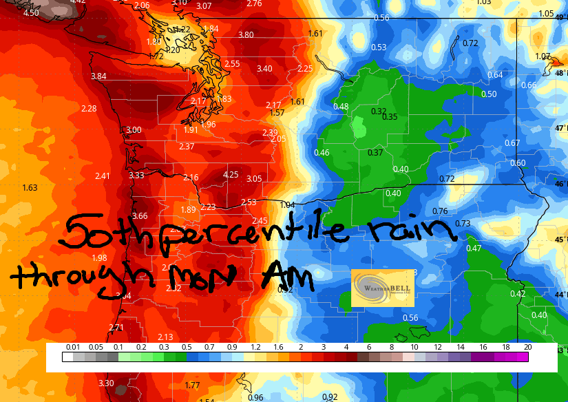
Good morning, neighbors! Not much going on here weather-wise today and tomorrow. Seems like a good opportunity for me to take a day off on Thursday! Mostly dry weather is forecast Wednesday and Thursday, and then all hell breaks loose with the arrival of an atmospheric river and a series of weather systems. All the details aren’t clear yet, but we’ll definitely get a good soaking Friday through Monday morning; even in the desert, models have 0.4” rain at the 50th percentile. Up in the mountains: inches of moisture with LOTS of snow above 7000′ and bunches of snow above 4000. How much? Let’s wait for a little more clarity and agreement in the models, but things are looking good up there for a solid early-season snowfall!
Glenwood this morning…
Before we dive in to all that, let’s check in with Glenwood. Once again, it’s cold: 27 degrees. In response to the cold this morning, all the residents of Glenwood are unpacking their puffy coats and dusting them off. Everyone in Glenwood has at least ten puffy coats in all colors of the rainbow. They want to be like my friend Megan! Sometimes Glenwood people have trouble deciding which puffy to wear, but they’re never lacking a warm jacket!
Today’s Gorge weather forecast
Elsewhere in the Gorge, most locations started in the upper 50s. Windy spots (Cascade Locks, Iwash Rock) were near 50F, and some of the higher elevation locations were in the mid 40s. We’ll have increasing clouds today, but temps still make it to 66F (Hood River), 68F (The Dalles), and 62F (The Desert). A little drizzle is possible west of Home Valley between 5pm and 11pm. Today’s wind will be E 30mph near Iwash (pecker) Rock early with E 20mph near Cascade Locks. Afternoon wind flip-flops like a taco and turns westerly at 15-20mph from Stevenson to Arlington.
Thursday’s Gorge weather forecast
Models bring another round of drizzle early Thursday. This one moistens the zone between Wyeth and Rowena, also known as the taint of the Gorge. It ain’t Cascade Locks, and it ain’t The Dalles. Therefore, it taint. For the rest of Thursday: mostly cloudy, nearly-calm, and 65 degrees all across the lowlands. Clouds stick around Thursday night, which annoys Glenwood because everyone there wants to drop below freezing every night, and they won’t on Thursday night.
Friday’s Gorge weather forecast
Friday kicks off clouds with temps in the mid 40s. By 8am, it’ll be raining in Cascade Locks. By 11am, Rowena. By 2pm, pouring rain enters the western Gorge. Heavy rain spreads eastward into the evening and eventually makes it all the way to Arlington before most of us go to bed and stop watching the radar. If nobody’s watching the radar, does rain fall? Up in the mountains, the snow level plummets from 10,000′ Friday morning to 6000′ overnight with a LOT of accumulation above 7000′.
Extended Gorge weather forecast
Cool, wet weather is forecast for the Gorge Saturday and Sunday. A period of very strong wind is possible Saturday night, but that’s far from certain at this point. Pass conditions deteriorate (if you’re just trying to get somewhere) or improve (if you are seeking your first ski turns of the season) over the weekend as the snow level falls from 6000′ Saturday morning to 5000′ Saturday afternoon and 3500′ Saturday night. In that period, 2.0-2.5” moisture is possible along with strong wind. This results in sloppy, slushy, snowy conditions on the roads. Saturday night will be a terrible time to drive the passes. Skip it if you can.
Other terrible times and locations to be driving locally: a good portion of the period between Friday night and Sunday morning, when periods of very heavy rain are possible for much of the 84/14 gauntlet. We’ll dive in a little deeper on the timing of the heaviest rain as we get closer. Still too much uncertainty to predict accurately. Stay dry out there. Safe travels. -TATAS
HEY! DON’T STOP READING! Is this community-focused forecast helpful to you? It sure is! It takes me a couple hours a day to write. Please join your friends and neighbors in contributing to keep it going. Venmo: @thegorgeismygym PayPal: twomirrors@gmail.com USPS: Temira / PO Box 841 / Hood River, Oregon 97031 You can test out the forecast subscription for a few days for free by signing up below. Easy! Do it!
MT HOOD SNOW FORECAST

CURRENTLY ON VACATION. WILL RETURN SOMETIME BEFORE THE START OF SKI SEASON AT MEADOWS, TIMBERLINE AND SKIBOWL. SAME GOES FOR THE NORDIC SKIING SEASON AT MEADOWS AND TEACUP!
JONES BEACH, SAUVIE ISLAND, & COAST FORECAST
Wind northerly unless otherwise indicated. For coast, it’s North/Central/South with the “central” at approximately Florence. Swell forecast from NWS for central coast. Sunday: 20-25/25/35+, W swell 7′ at 11 seconds. Monday: 20/20-25/25-30, W 4′ @ 10. Tuesday: 10-15/10-15/25, W 6′ @ 12. Jones Sunday: 16-19. Monday: LTW. Tuesday: 10-13. Sauvie Island Sunday: 16-19. Monday: 10-13. Tuesday light/variable.
