

MT HOOD SNOW FORECAST

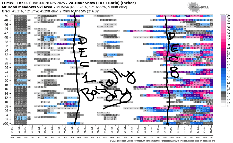
Hey skiers and snowboarders! Welcome to another edition of “waiting for snow”! And welcome to the new folks joining us thanks to the Axios article. Hopefully y’all will stick around for the “heck yeah it’s ski season” editions of this forecast! Not much happens in the next 10 days or so. There’s some indication of upwards movement in the snowpack starting the weekend of December 6th, when naturally I’ll be on a five day meditation retreat. That’s how these things roll sometimes!
Today’s Mt Hood snow forecast
Let’s take a look at Wednesday: light rain on the slopes. The snow level starts at 6500′ and rises to a rather unseasonable 9000′ by midnight. About 0.2” rain is forecast this morning with clearing sky tonight. Wind: W 20 this morning, SW 10 midday, SW 10-20 from late afternoon on into the night.
Thanksgiving Mt Hood snow forecast
Thursday starts clear but quickly adds rain. While some sources are calling for up to half a foot of snow in the Cascades at 5000′, I’m not seeing it. Temps at 850mb (5000′) remain at +2C until the tail end of the moisture. Thursday starts with the snow level around 9000′. It falls to 5500′ by mid-morning and eventually drops to 4500′ after midnight. During the daylight hours, we’ll pick up 0.2” rain or snain (very wet snow). Overnight, another 0.4” water equivalent (WE) is forecast. We could see an inch of snow at 5000′ at the tail end, but temps look too warm for more than that. Wind: SW 10-20 early with a quick build to SW 30-45. That holds into the evening and switches to W 40 after midnight. That could increase the precip total thanks to orographic assistance. So, I guess it’s possible we’ll see a couple inches of snow at 5000′, but that’s about it.
Extended Mt Hood snow forecast
Friday starts with light snowfall, quickly turns clear, then high cloudy. The snow level will be 5000′ early and will fall to 3000′ in the afternoon. Overnight, air masses of varying temps compete for dominance; we’re left with a fluctuating freezing level for Saturday morning. Definitely a cooling trend, tho! Friday morning could see an inch of snow before precip ends around 10am. Wind: NW 30-35 early, NW 15-20 mid-morning, NE 10 in the afternoon, and S 5-10 after midnight.
Cooler air arrives for the weekend, but this will also be dry air. Next chance for snow is Tuesday into Wednesday, but ensembles aren’t calling for much, if any. Beyond that, we have dry weather most of next week. Ensembles hint at precip returning for the weekend of the 6th of December, but they’re uncertain about the temps; as of right now the ensembles of the Euro have 850mb (5000′) temps running between -4C and +3C, which means snow is not guaranteed. We’ll keep an eye on it. Until then, keep up that dryland training routine. See you on the snow soon!
Was that helpful? I knew it was! Guess what? All of this crucial work – from your personal wind and snow reports to the invaluable TATAS updates – is made possible by my relentless efforts. Maintaining this labor of love isn’t easy. Each daily forecast takes hours. Website hosting, weather model access, and back-end admin work takes time and money. That’s where you come in.
YOUR CONTRIBUTION MAKES A DIFFERENCE
- SUPPORT ACCURATE, HYPER-LOCAL WEATHER FORECASTING
- ENABLE ACCESS FOR ALL, EVEN THOSE WITH LESS MEANS
- SUPPORT A COOL HUMAN WHO WORKS HARD SO YOU CAN PLAY
Take a moment to click one of the buttons below. Donate $19.99 or more (how much does this forecast enhance your life?) and get the email in your inbox. Whether it’s a renewing subscription (auto-renew) or a one-time donation, every contribution makes a real difference. Help me keep this labor of love alive, so we can all continue playing, commuting, and living in the Gorge with peace of mind and the best weather forecasts possible. Thank you!


Hood River, Oregon 97031


GORGE WIND FORECAST
If you’re still seeing yesterday’s and it’s after 9am, try opening this in an incognito window
today’s gorge wind forecast
Hi friends! Not much to report this morning, but you know I’ll still report it! Out of the next five days, four of them will have easterlies, but wind strength will be marginal. Or maybe I’m extra picky with easterlies and personally want 30+ at Stevenson before I’ll consider it!
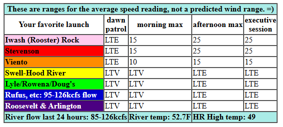
Wednesday kicks off light and variable. Easterlies slowly build through the day and finish up at 25mph at both Iwash (Rooster) Rock and Stevenson with 15-20mph at Viento. River flow over the last 24 hours was 85-133kcfs, river temp is 52.7F, and high temp forecast is 48F.
RIVER FLOW FOR SITES BETWEEN AVERY (EAST OF THE DALLES) AND RUFUS: CLICK HERE FOR JOHN DAY DAM FLOW.
RIVER FLOW FOR SITES BETWEEN STEVENSON AND DOUG’S BEACH (WEST OF THE DALLES): CLICK HERE FOR THE DALLES DAM FLOW

tomorrow’s gorge wind forecast
Thursday stats with 25 at Stevenson and 30-35 at Iwash. The wind holds for a few hours in the morning (with rain) and drops in the afternoon. At 4pm, Stevenson will be down to 15-20mph and Iwash 10-15mph. Overnight, the wind turns westerly, probably strong enough, but definitely too dark. High temp: 47F with pie. Lots of pie!
extended Gorge wind forecast
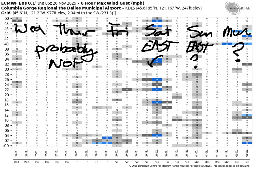
Friday starts with lingering westerlies, but probably under 15mph. In the afternoon, the wind turns calm. High temp: 50F with clouds early and sun later. Saturday and Sunday both look like east wind days (for now – it’s complicated), but strength is uncertain. See you out there someday! Oh PS, don’t forget the Turkey Trot at the Twin Tunnels on Thanksgiving morning!
BARE BONES HOOD RIVER WEATHER FORECAST
Rain this morning, then a break, then rain again this afternoon. Break: 10am-1pm or so. Temps start in the low 40s and rise to the upper 40s. Light easterlies. 14% chance of rainbows. Thursday will be rainy then dry then rainy. Temps start near 40 and rise to the mid-upper 40s. Light easterlies. 18% chance of rainbows. Friday will be dry after sunrise. Cloudy to start, high clouds with filtered sun later. Temps start in the low 40s and rise to 50. Light westerlies. 76% chance of an early morning rainbows.
TEMIRA’S AWESOME TRAVEL ADVISORY SERVICE
HYPERLOCAL WEATHER FORECAST FOR THE COLUMBIA GORGE
THE DALLES, HOOD RIVER, WHITE SALMON, TROUT LAKE, STEVENSON, CASCADE LOCKS, PARKDALE, ODELL, HUSUM, BZ, MILL A, WILLARD, GOLDENDALE, RUFUS, ARLINGTON, boardman

Good morning, neighbors! Wow. It is 100% Pacific Northwest winter out there right now. Low clouds, fog, rain on Underwood, no wind. Dark, gloomy, and gray, just how we like it! We’ll have quite a bit of this over the next few days, and then we have at least some chance of blue sky and sun as cooler, drier air infiltrates the region.
Glenwood, WA, this morning
Looking around our region this morning, we start with the nether region. Mine’s about 10% white. How about yours? The nether region of Glenwood is 37 degrees. Coincidentally, the gray percentage of the nether regions in Glenwood is 37%. It’s worth noting that pubic hair does thin as we age. I plan to compensate for this by applying minoxidil to my nether region so I have the capacity for Full Bush In A Bikini well into my 90s.
Wednesday’s Gorge weather forecast
For the rest of us today… drizzle early, a break midday at least east of Corbett, and rain again after 1pm. That later band of rain moves through quickly. Starting time: 1pm west of Hood River. Finishing time: 10pm east of the Arlington Triangle. Between 4pm and 7pm, rain will be moderate in strength and annoying to drive in west of Biggs. Today’s high temp rises to 50 in The Dalles and slight less to the east and west. Most places see very little wind, but Iwash (RELEASE THE ENTIRETY OF THE FILES) Rock and Stevenson slowly build to east 25mph.
Thanksgiving Gorge weather forecast
Yet another round of rain is forecast for Thanksgiving, thank the stars and the pardoned turkey. Speaking of pardons… no, never mind, I’m not going there. Rain extends to Celilo Village by 5am and makes it all the way to the Tri-Cities shortly after. Rain intensity backs off midday and increases again late afternoon into the evening. Overnight, we’re looking at moderate to heavy rain for much of the Gorge, first to the north, then to the south. Low temp Thursday morning will be around 40F. Highs: 46F, 47F, and 48F for the lowlands. Wind starts at E 30mph near Iwash (pen!s) Rock and Stevenson and fades to 15mph in the afternoon before turning westerly overnight. All this rain will make for a fun Turkey Trot at the west end of the Twin Tunnels in the morning. You should do this run! It benefits the Mosier School!
Extended Gorge weather forecast
Early morning drizzle on Friday gives way to dry weather and some sunshine. Sun! Yay! Dry! Yay! Temps start near 40 thanks to light west wind. Temps rise to 50 thanks to sun. Cooler air starts to filter in over the weekend, but nothing extreme is forecast. Let me double-check the Extreme Forecast Index. Nope. Nothing interesting other than some 0.78 high-low temps for the Valley of Willies to finish off this week. Looking at next week, we see mostly dry weather. That’s followed by a probable return to damp weather for the following weekend, which is fine by me because I’ll be on retreat. Ah, blessed silence. Safe travels. -TATAS
HEY! DON’T STOP READING! Is this community-focused forecast helpful to you? It sure is! It takes me a couple hours a day to write. Please join your friends and neighbors in contributing to keep it going. Venmo: @thegorgeismygym PayPal: twomirrors@gmail.com USPS: Temira / PO Box 841 / Hood River, Oregon 97031 You can test out the forecast subscription for a few days for free by signing up below. Easy! Do it!
JONES BEACH, SAUVIE ISLAND, & COAST FORECAST
ON WINTER VACATION UNLESS DESPERATELY NEEDED.
