

GORGE WIND FORECAST
today’s gorge wind forecast
Hi friends! After a couple of light wind days, you’re probably ready to get back on the river. Ma Nature (and the Gorge wind forecast, of course) is ready to fulfill your desires today. Tomorrow looks like a rest day, but that’s followed by three more days of west wind of varying strength. Let’s take a look at what’s on tap today:
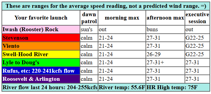
A weak cold front heads for the region today (it’s Wednesday), and high pressure is set to build behind. Ideal this isn’t, but it’s definitely going to be good enough. Pressures at 6am were 29.99/29.94/29.92, onshore but not doing much. By 11am, we should have 21-24 from Stevenson to Mosier with 12-15 from Lyle to Avery. Wind speeds ramp up from there. Early afternoon brings 23-26 from Stevenson to Rufus. Mid afternoon sees the wind climb to 27-31 most places between Stevenson and Arlington with 22-25 at Threemile. Clouds push in from the west to Hood River (maybe Mosier) around 4pm (if models are correct). Just prior to that, we should see a burst of stronger wind near the Hatch. Once those clouds arrive, wind speeds drop below them and rise east of them as the offshore high pressure exerts its influence. Windiest spots today will be between Mosier (or Lyle) and Avery, but everywhere will be plenty windy to get you on the river. River flow over the last 24 hours was 204-255kcfs (220-241kcfs at Rufus), river temp is 55.6F, and high temp forecast is 75F. Gosh, that’s a nearly perfect day on the river, isn’t it?

tomorrow’s gorge wind forecast
Thursday starts with lingering west wind at 13-16 from Viento to Hood River with 10-13 from Mosier to The Dalles and light wind out east. The wind drops below 10mph midday and holds through the afternoon. Evening westerlies return at 10-13mph from Stevenson to Mosier. High temp: 72F with mostly clear sky and a few high clouds.
extended Gorge wind forecast
A calm start on Friday belies a windy day on tap. A slow and steady build gets you on the river early afternoon with 18-21 from Stevenson to The Dalles. After a few hours of that, areas west of Mosier drop to 16-19, the Mosier to Avery stretch rises to 21-24, and Celilo to Rufus climbs to 19-22. High temp: 79F with just a few high clouds.
Looking to the weekend, we see wind. Moderate westerlies in the teens are forecast for Saturday. Sunday looks windier, perhaps mid-20s and gusty as a weather system approaches. Beyond that, models generally keep some sort of west wind in the picture, but there’s a lack of clarity on strength. Best consensus for a stronger wind day is next Wednesday. We are also expecting more clouds and some light rain early next week with high temps through the week in the upper 50s to low 60s, on the cool side for this time of year. See you on the Nch’i Wana!
Was that helpful? I knew it was! Guess what? All of this crucial work – from your personal wind and snow reports to the invaluable TATAS updates – is made possible by my relentless efforts. Maintaining this labor of love isn’t easy. Each daily forecast takes hours. Website hosting, weather model access, and back-end admin work takes time and money. That’s where you come in.
YOUR CONTRIBUTION MAKES A DIFFERENCE
- SUPPORT ACCURATE, HYPER-LOCAL WEATHER FORECASTING
- ENABLE ACCESS FOR ALL, EVEN THOSE WITH LESS MEANS
- SUPPORT A COOL HUMAN WHO WORKS HARD SO YOU CAN PLAY
Take a moment to click one of the buttons below. Donate $19.99 or more (how much does this forecast enhance your life?) and get the email in your inbox. Whether it’s a renewing subscription (auto-renew) or a one-time donation, every contribution makes a real difference. Help me keep this labor of love alive, so we can all continue playing, commuting, and living in the Gorge with peace of mind and the best weather forecasts possible. Thank you!


Hood River, Oregon 97031


JONES BEACH, SAUVIE ISLAND, & COAST FORECAST
Wind northerly unless otherwise indicated. For coast, it’s North/Central/South with the “central” at approximately Florence. Swell forecast from NWS for central coast. Wednesday: 10-15/15/25-20, W swell 7′ at 12 seconds. Thursday: 20-25/20/20-25, W 6′ @ 11. Friday: LTW/LTW/N15-20, W 5′ @ 11. Jones Wednesday: 12-15. Thursday: 13-16. Friday: 20-23. Sauvie Island Wednesday: 15-18. Thursday: 11-14. Friday: 10-13.
BARE BONES HOOD RIVER WEATHER FORECAST
Partly high overcast today with increasing low/mid clouds late. Temps start in the low 40s and rise to the mid 70s. Light west wind early. Strong west wind late. No rainbows. Thursday will be mostly clear. Temps start in the low 40s and rise to the low 70s. Light westerlies. No rainbows. Friday will be partly high overcast. Temps start in the mid 40s and rise to the upper 70s. Calm wind early. Moderate westerlies later. No rainbows.
TEMIRA’S AWESOME TRAVEL ADVISORY SERVICE
HYPERLOCAL WEATHER FORECAST FOR THE COLUMBIA GORGE
THE DALLES, HOOD RIVER, WHITE SALMON, TROUT LAKE, STEVENSON, CASCADE LOCKS, PARKDALE, ODELL, HUSUM, BZ, MILL A, WILLARD, GOLDENDALE, RUFUS, ARLINGTON, boardman
Good morning, neighbors! Fun Sun continues into Saturday, and then we have a (slight) chance of rain for the next few days. Temps fall from 70-80 this week to 60ish for much of next week. Beyond next next Thursday, uncertainty increases with 10+ degrees of spread in the temp forecasts. But given that next Thursday is 8 days away, there’s no need to plan that far out. ANYTHING could happen between now and then! Want to make that stretch of time better? Practice kindness. Towards yourself. If you can cool the fires of cruelty internally, you will naturally be kinder to the world around you. And if you allow the internal cruelty to continue, you’ll expend a lot of energy controlling your external behavior. TATAS recommends exquisite kindness and friendliness towards all internal processes for the best results in life.
glenwood and other cold spots
Moving on (but not forgetting that advice because it’s good advice if I do say so myself)… let’s say good morning to Glenwood. Glenwood, I’m waving to you friendly-style as I type this. It’s 33 degrees there this morning with a dewpoint of 30 and a few high clouds. I couldn’t find any locations at 32 or below this morning, and nor could I find any dirty place names on the very detailed NWS map I use to find the cold spots. People, it’s time to submit some place name changes to whoever manages that stuff.
today’s gorge weather forecast
Since it’s no longer winter, us starting the day (it’s Wednesday) above freezing means we’ll (thankfully) stay above freezing all day. Hooray! By the way, that was not the case when I was in Massachusetts: one day we started at 37F and finished at 27F. That was EXCITING! Temps here today max out around 75F in the lowlands. 75 is PERFECT. I support this result. While there wasn’t really any wind to start, there will be lots of wind to finish off your Wednesday: westerlies rise to 25-30 mph all along the Nch’i Wana (“Big River”) by this afternoon. Low clouds move in from the west and make it to, oh, Hood River or Mosier or Lyle this afternoon. Please, please be careful with fire and sparks today. If you start a fire, it’s likely to spread quickly. Let’s make an attempt at zero human-caused fires this year.
thursday’s gorge weather forecast
This system moving in is a chilly one – temps at 5000′ will drop to -2C tonight under mostly clear sky. Light west wind lingers, thankfully, which will protect many of us from frost on Thursday morning. Locations to watch for sub-freezing temps: Glenwood (duh), lower Parkdale, and that’s about it with the westerlies in the forecast. Obviously areas above 4000′ are likely to be sub-freezing Thursday morning (setting up a great day for corn snow on the mountain), but none of you live above 4000′. After that chilly start, temps rise to 72F or so in the lowlands under mostly clear sky. West wind falls from 10-15mph early to less than 10mph midday and returns at 10-15mph west of Mosier, and only west of Mosier, late in the day.
friday’s gorge weather forecast
High clouds Friday morning set us up for a colorful sunrise. Note: it’s not a “good” sunrise. All sunrises are equally good because all sunrises mean that we aren’t going to end the day as blocks of ice. Speaking of… excuse me while I go do my morning gratitude to the sun for rising… Okay. I’m back. Me and the sun just had a nice moment together. It’s a very friendly ball of fire! Back to Friday’s forecast… a few high clouds all day let temps climb to nearly 80F. Wind will be calm to start (spray, baby, spray!) with a slow build to 20-25mph out of the west between Stevenson and Avery in the afternoon. At Amayah’s (the location formerly known as Biggs) and Bob’s Texas T-Bone (the location formerly known as Rufus), westerlies rise to 20mph. East of there: 10-15mph or less. Another “nice” day is forecast for Saturday, but remember, every day is “nice” because the sun didn’t die or go supernova and we still exist as a species.
extended gorge weather forecast
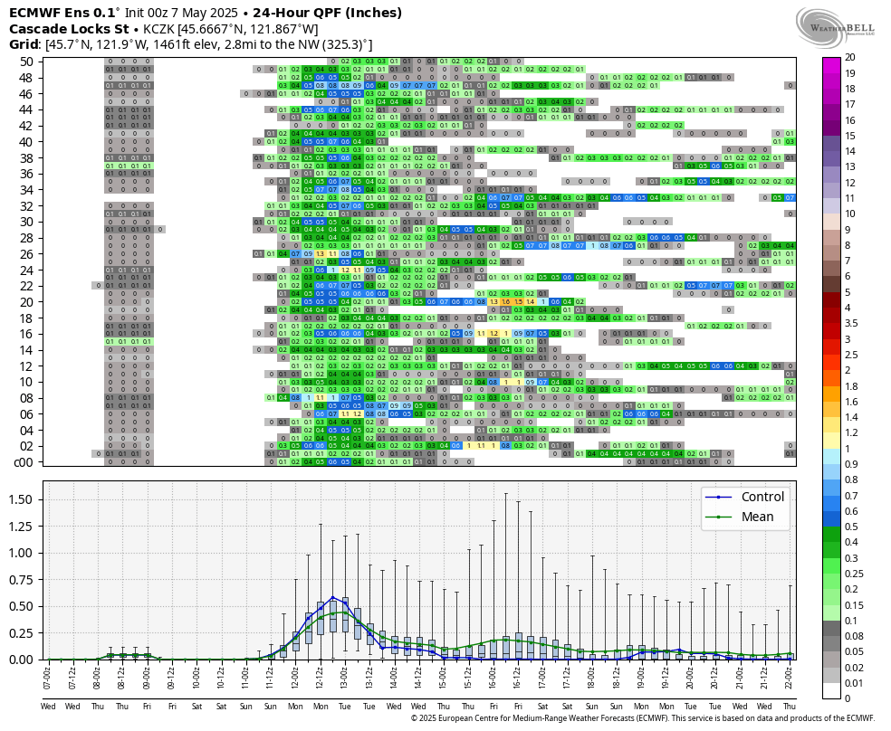
Starting Sunday, cooler, cloudier, potentially showery weather, is forecast for the west side of the Cascade Crest. There are even some days where a little drizzle could fall as far east as The Dalles and maybe even beyond! There’s not enough rain to make a real dent in the April rain deficit, but some rain is better than none. Take a look at the Euro 24 hour QPF graphic for potential rainfall along the Cascade Crest. Valuable Advice for Gardeners Inhabiting Neighboring Areas: this upcoming period of cooler, damper weather is going to be excellent for getting seeds in the ground and germinating them. It will also be great for weeding, one of my favorite activities. There are few things more satisfying than clearing the weeds from an entire bed and exposing the beautiful soil. Best done with your buttocks out: sun’s out buns out! Happy gardening. Safe travels. -TATAS
HEY! DON’T STOP READING! Is this community-focused forecast helpful to you? It sure is! It takes me a couple hours a day to write. Please join your friends and neighbors in contributing to keep it going. Venmo: @thegorgeismygym PayPal: twomirrors@gmail.com USPS: Temira / PO Box 841 / Hood River, Oregon 97031 You can test out the forecast subscription for a few days for free by signing up below. Easy! Do it!
