

MT HOOD SNOW FORECAST

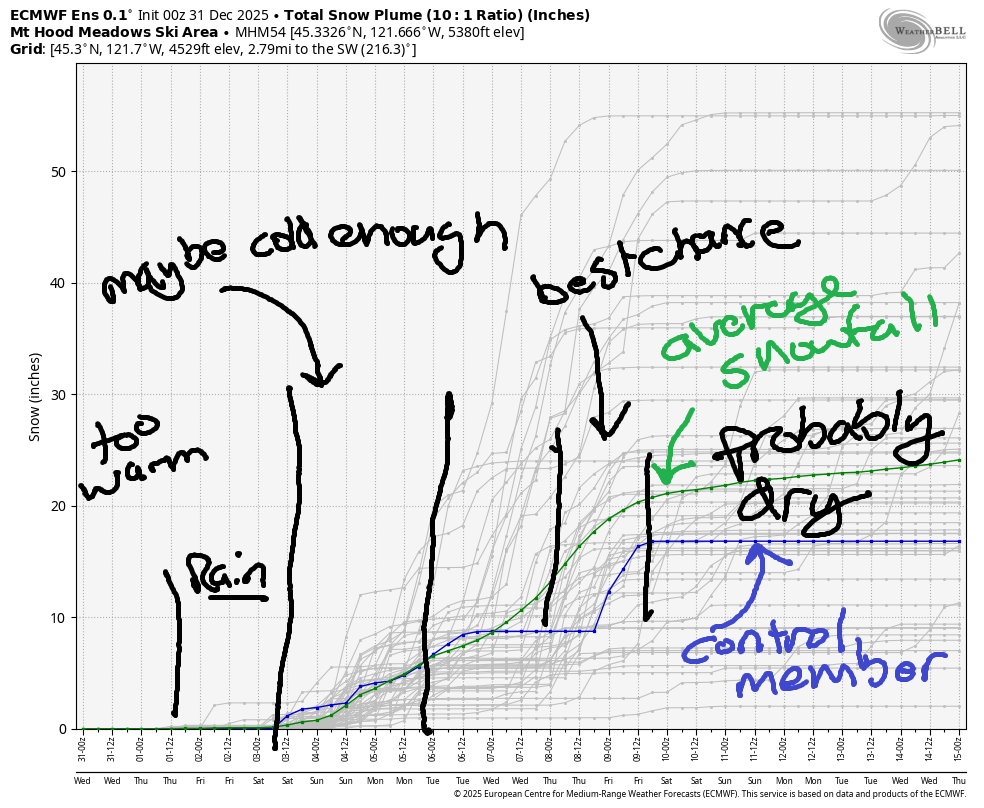
Hey skiers and snowboarders! It’s definitely not a powder day on Mt Hood, but we have the next best thing: sunshine most of the day and fireworks tonight! You can also expect warm weather on the mountain today – temps were in the mid 40s above 6000′ this morning with 30ish degrees at the lower elevations. Looking ahead for the next several days, we have, unfortunately, periods of light rain. Models suggest temps will drop enough for snow sometime between Sunday and next Tuesday, but there’s quite a bit of uncertainty. Intraquartile range for total snowfall over the next two weeks is 15-30”.
Short term Mt Hood snow forecast
Wednesday starts out clear and eventually adds some high clouds. The free air freezing level will be around 12,000′ with max temps in the mid to upper 40s on the slopes, cooler the lower in elevation you go. Snow conditions are hardpack down low, but will be warming transitional snow higher up, or at least that’s what grooming crew told me! Wind will be light SW all day.
Thursday starts cloudy and adds some light rain mid-morning, although the timing isn’t certain. The snow level will be 10,000′ early, 8500′ in the afternoon, and 2000′ overnight. It’s worth mentioning that lower elevations are likely to be below freezing and would thus see freezing rain, making for a potentially very slick drive to the mountain. Just a trace of rain is forecast during the day. Overnight: 0.2” to 0.4” rain. Wind will be SW 10-15 early, SW 15-20 in the afternoon, and SW 25-40 overnight.
Extended Mt Hood Snow Forecast
Light rain starts the day on Friday. It should finish up mid-morning and leave the mountain partly cloudy. Another round of very light rain or mixed precip is forecast overnight. The snow level will be 7000′ in the morning and will fall to 5500-6000′ overnight. About 0.2” to 0.4” rain is forecast in the morning. A trace is forecast overnight. Wind: SW 25-45 in the morning, SW 10-20 in the afternoon, and SW 15-25 overnight.
A trace of mixed precip is forecast next Saturday. Starting Sunday, there’s more uncertainty in the forecast regarding the snow level and the amount of precipitation. There will be some precipitation, but it’s unclear what type. As I mentioned in the first paragraph, total snowfall over the next couple of weeks is forecast to be 15-30”. While that would be a lot if it came over a couple days, it’s not all that much for a couple of weeks. But it’s certainly better than nothing. Fingers crossed for the upper end! Fingers crossed also for no big rainstorms – as of right now, I also don’t see the Pineapple Express in the next couple of weeks, yay! Have a great day on the slopes today. Enjoy your New Year’s Eve celebrations!
Was that helpful? I knew it was! Guess what? All of this crucial work – from your personal wind and snow reports to the invaluable TATAS updates – is made possible by my relentless efforts. Maintaining this labor of love isn’t easy. Each daily forecast takes hours. Website hosting, weather model access, and back-end admin work takes time and money. That’s where you come in.
YOUR CONTRIBUTION MAKES A DIFFERENCE
- SUPPORT ACCURATE, HYPER-LOCAL WEATHER FORECASTING
- ENABLE ACCESS FOR ALL, EVEN THOSE WITH LESS MEANS
- SUPPORT A COOL HUMAN WHO WORKS HARD SO YOU CAN PLAY
Take a moment to click one of the buttons below. Donate $19.99 or more (how much does this forecast enhance your life?) and get the email in your inbox. Whether it’s a renewing subscription (auto-renew) or a one-time donation, every contribution makes a real difference. Help me keep this labor of love alive, so we can all continue playing, commuting, and living in the Gorge with peace of mind and the best weather forecasts possible. Thank you!


Hood River, Oregon 97031


GORGE WIND FORECAST
If you’re still seeing yesterday’s and it’s after 9am, try opening this in an incognito window

SHORT-TERM gorge wind forecast
Hi friends! Hopefully some of you have been getting out for some east wind playtime. Not me. Too cold for me! You’ll have two more days of easterlies before the wind shuts down for a bit. Wednesday started with clear sky (yay) and pressures of 30.18/30.35/30.35. East wind around 6:30am was 40mph at Iwash (Rooster) Rock, 25mph at Stevenson and and 23mph at Viento (thanks, iWind/iKite). We’ll see easterlies peak at 45mph at Iwash and 35mph at Stevenson today with 25mph at Viento. The wind fades about 5mph after1pm. River flow over the last 24 hours was 153-216kcfs, river temp is 45.3F, and high temp forecast is 39F.
RIVER FLOW FOR SITES BETWEEN AVERY (EAST OF THE DALLES) AND RUFUS: CLICK HERE FOR JOHN DAY DAM FLOW.
RIVER FLOW FOR SITES BETWEEN STEVENSON AND DOUG’S BEACH (WEST OF THE DALLES): CLICK HERE FOR THE DALLES DAM FLOW

LONGER-TERM gorge wind forecast
On Thursday, easterlies continue, but they may be joined by drizzle and/or freezing drizzle. Wind will be around 30mph at Stevenson and 40mph at Iwash all day long. High temp: 37F with clouds and drizzle.
Friday starts with light easterlies, perhaps 15mph at both Stevenson and Iwash. By 10am, the wind drops below 10mph. For most locations in the Gorge, the wind will be calm all day. Easterlies of some sort are likely Saturday and Sunday as low pressure systems slide up the coast and keep the pressure gradient offshore. No sign of westerlies any time soon. If you’re going out, dress for an emergency, have an emergency plan, and keep an eye on your buddies. It’s cold out there!
BARE BONES HOOD RIVER WEATHER FORECAST
Clear sky today. Temps start in the mid 20s and rise to the upper 30s. Light easterlies. No rainbows. Thursday will be cloudy with light rain or freezing rain depending on timing. Temps start in the upper 20s and rise to the upper 30s. Light easterlies. No rainbows. Friday will be rainy to start then dry and cloudy. Temps start in the low-mid 30s and rise to the low 40s. Calm wind. 2% chance of rainbows.
TEMIRA’S AWESOME TRAVEL ADVISORY SERVICE
HYPERLOCAL WEATHER FORECAST FOR THE COLUMBIA GORGE
THE DALLES, HOOD RIVER, WHITE SALMON, TROUT LAKE, STEVENSON, CASCADE LOCKS, PARKDALE, ODELL, HUSUM, BZ, MILL A, WILLARD, GOLDENDALE, RUFUS, ARLINGTON, boardman
Good morning, neighbors! I tried really hard to not write a forecast yesterday, and I succeeded in that. Unfortunately, I ended up online a lot due ¡cy roads in The Dalles. So far, roads appear clear of that kind of slipperiness this morning, but they’re definitely covered in frost and/or slick spots many areas. Be careful out there!
Glenwood this morning
Not only do we have slippery roads, we have chilly chilly temps. It’s a good day for a pot of chili, and dang it, it would have been an okay day to cool your vast pot of chicken stock off outside. Hurry up and make chicken stock – you can cool it off outdoors tonight. Now, let’s say hi to Glenwood. It’s 19 degrees there this morning. Other impressive temps: 18F and 19F in Trout Lake, lots of 21Fs in Parkdale, and 19F near Booth Hill road. In a fun twist, it’s MUCH warmer aloft – at the top of Mt. Hood Express (6300′), it’s 45 degrees!
Today’s Gorge weather forecast
We are expecting a sunny morning with scattered Nothing to the east. By afternoon, we’ll have some high clouds. Out near the Tri-Cities, folks may be trapped in the Nothing and freezing fog all day. If that’s you, I’m sorry. Temps max out in the upper 30s to low 40s today. If you head to Iwash (big d*ldo) Rock, you’ll find east wind at 40-45mph. Stevenson: 30-35mph. Elsewhere: 5-10mph.
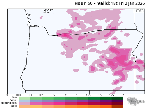
Clouds move in overnight. Depending on the timing of those clouds and Thursday’s precipitation, things could get interesting. Temps are forecast to start in the 20s on Thursday morning, and models currently have precip arriving around 10am. With temps aloft near 40F and the snow level well above 6000′, we’re looking at a strong possibility of light freezing rain for at least outlying areas of the Gorge on Thursday.
This system arrives from the SSW, which means we’ll see light freezing rain pretty much everywhere starting in our southern zones: Parkdale, south Wasco, Sherman county, Gilliam county. Now, total precip by the afternoon is just a trace. Heavier rain is forecast overnight, which could add to the ice totals. Temps are forecast to rise to the upper 30s near the river by afternoon, which would end the threat of freezing rain at our lowest elevations.
Check out the freezing rain map for the model idea of what will happen.
Let’s dive in a little deeper: for freezing rain to happen Thursday, we’ll need clear-enough sky tonight (Wednesday, NYE) for temps to fall below freezing. We’ll need rain to arrive early enough on Thursday for temps to still be below freezing and also for surfaces to not be warmed by solar heating. Now we talk about the escape from this pattern: given the lack of incoming west wind, cold air will need to dissipate via solar heating and scouring from aloft – there is no maritime air coming to save us. It’s possible some areas could see icing into Friday when somewhat heavier precipitation is forecast, but mostly west of The Dalles.
I guess we’ll be looking more closely tomorrow morning, won’t we?
Extended Gorge weather forecast
Extended forecast: so, like I said, some rain/freezing rain Friday (mostly) west of The Dalles. Light wind. High temps in the low 40s. Light rain is likely Saturday morning, and most of Sunday looks dry. Looking at the next couple of weeks, there’s pretty much zero sign of any widespread winter weather event for the Gorge. That’s all I’ve got for you today. Have a joyous new year’s eve! Safe travels. -TATAS
HEY! DON’T STOP READING! Is this community-focused forecast helpful to you? It sure is! It takes me a couple hours a day to write. Please join your friends and neighbors in contributing to keep it going. Venmo: @thegorgeismygym PayPal: twomirrors@gmail.com USPS: Temira / PO Box 841 / Hood River, Oregon 97031 You can test out the forecast subscription for a few days for free by signing up below. Easy! Do it!
JONES BEACH, SAUVIE ISLAND, & COAST FORECAST
ON WINTER VACATION UNLESS DESPERATELY NEEDED.
