

MT HOOD WEATHER FORECAST
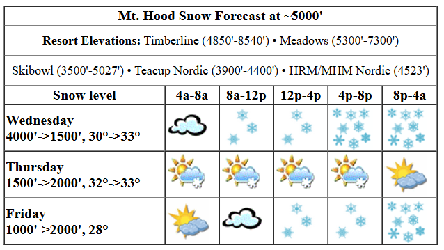
Hey skiers and snowboarders! The forecast is full of good news through the weekend despite the possibility of a brief period of mixed precip. With 4.0”-5.5” water equivalent (WE) in the forecast between now and Monday, we’re going to see Mt. Hood transform back into a winter wonderland! Heaviest snowfall will be today into tonight followed by Friday evening through Sunday midday. In other words, the least snowy days will be Thursday and Friday. Let’s dive in to the Mt Hood weather forecast, shall we?
About an inch of snow fell last night, but we’re set up for more snow today. Meadows is calling the current conditions “dust on crust appetizer” to the incoming powder. I got a laugh out of that, and hopefully you did too. The snow level today will be about 3500′ early, 4000′ in the afternoon, and down to 1000-1500′ overnight. About 0.4” WE is forecast daytime, for 3-5” new snow. Overnight, we have another 0.6” WE in the picture for 6-7” of increasingly dry powder. Add in strong wind this evening for deep wind loaded freshie buildup! Today’s wind: SW 10-15 in the morning, variable to 10 in the afternoon, and W 40 overnight.
Thursday kicks off with light snowfall. Thanks to atmospheric instability, Mt. Hood picks up on-and-off snow flurries into the evening. If past performance is indicative of Thursday’s weather, snow totals will under-perform, but here’s what the models say: 0.1” WE in the morning, 0.2” WE in the afternoon, and 0.1” WE overnight. The snow level will be around 1500′ early, 2000′ in the afternoon, and down near 0-1000′ overnight with partly cloudy sky. Temps will be in the low-mid 20s. With those temps, that 0.4” WE total gives us 4-5” new powder in the 24 hour period. Wind: W 40 early, WSW 25-30 in the afternoon, W 20 in the evening, and SW 5-10 after midnight.
Extended Mt Hood Weather Forecast
Cool, cloudy weather Friday morning gives way to light snow in the afternoon and very heavy snowfall overnight. Woohoo! The snow level will be 0-1000′ in the morning and 2000′ from mid-afternoon on. Temps start in the low-mid 20s and rise to the upper 20s. About 0.1” WE is forecast in the afternoon for an inch of new snow. Overnight, models are currently predicting 1.2” WE for 11-14” new snow. YES! Wind: S 5-10 in the morning, E 20 briefly in the afternoon, WSW 25-30 in the evening, and WSW 40-45 after midnight. Classic storm skiing is forecast on Saturday with at least half a foot of snow during the day and a foot or more overnight. It’s possible there will be a period of mixed precip in there; if not, the snow will be dense and heavy. Sunday brings another half a foot of snow and, by then, a complete transformation of the slopes. Sounds awesome. My fingers are crossed that the forecast holds. Hope to see you out there!
Was that helpful? I knew it was! Guess what? All of this crucial work – from your personal wind and snow reports to the invaluable TATAS updates – is made possible by my relentless efforts. Maintaining this labor of love isn’t easy. Each daily forecast takes hours. Website hosting, weather model access, and back-end admin work takes time and money. That’s where you come in.
YOUR CONTRIBUTION MAKES A DIFFERENCE
- SUPPORT ACCURATE, HYPER-LOCAL WEATHER FORECASTING
- ENABLE ACCESS FOR ALL, EVEN THOSE WITH LESS MEANS
- SUPPORT A COOL HUMAN WHO WORKS HARD SO YOU CAN PLAY
Take a moment to click one of the buttons below. Donate $19.99 or more (how much does this forecast enhance your life?) and get the email in your inbox. Whether it’s a renewing subscription (auto-renew) or a one-time donation, every contribution makes a real difference. Help me keep this labor of love alive, so we can all continue playing, commuting, and living in the Gorge with peace of mind and the best weather forecasts possible. Thank you!


Hood River, Oregon 97031


GORGE WIND FORECAST

Hi friends! Very active weather is in the cards for the next couple of weeks. This means we’re counting (mostly) on frontal passages and lows moving inland to drive the wind rather than offshore high pressure driving it. Not much happens today (Wednesday), at least not while it’s light outside. Easterlies peak at 15-20mph this morning at Iwash and turn calm by late morning. Strong west wind arrives after sunset. Both my river flow sites are down this morning, so … river temp is 42.6F. High temp forecast is 51F with rain from mid-morning on.
Thursday brings west wind thanks to a low moving inland and intensifying as it exits to the north. Dawn Patrol westerlies will be 12-15ish west of The Dalles and 25-28ish to the east. Westerlies briefly bump up to gusty 15-18 from Stevenson to Doug’s mid-morning. Best results will be out east, but it’s going to be right on the edge of “enough” – remember that those sensors read higher than the western Gorge sensors, and I’m forecasting for the sensor readings. Call it 25-28ish all day long from Avery to Boardman. High temp: 48F with clouds and showers and instability west of The Dalles all day with partly cloudy sky out east. Easterlies return on Friday at 20-25mph from mid-morning on at both Iwash (Rooster) and Stevenson. Next best chance for wind is probably Monday. Have fun out there!
BARE BONES HOOD RIVER WEATHER FORECAST
Clouds today with rain from mid-morning on. Temps start in the low 40s and rise to the low 50s. Calm wind. 11% chance of rainbows. Thursday will be showery all day. Temps start in the upper 30s and rise to the upper 40s. Moderate westerlies. 99.99% chance of rainbows. Friday will be High overcast and dry in the morning with rain in the afternoon. Temps start in the low-mid 30s and rise to the mid 40s. Light easterlies. 4% chance of rainbows.
TEMIRA’S AWESOME TRAVEL ADVISORY SERVICE
HYPERLOCAL WEATHER FORECAST FOR THE COLUMBIA GORGE
THE DALLES, HOOD RIVER, WHITE SALMON, TROUT LAKE, STEVENSON, CASCADE LOCKS, PARKDALE, ODELL, HUSUM, BZ, MILL A, WILLARD, GOLDENDALE, RUFUS, ARLINGTON, boardman
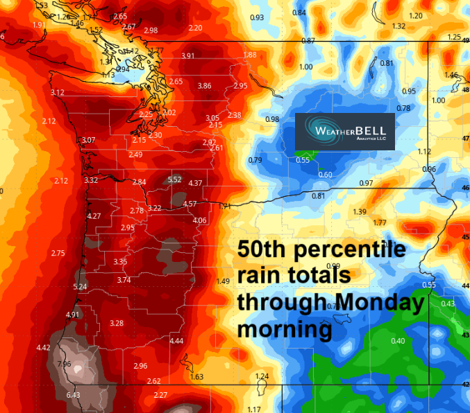
Good morning, neighbors! Sitting here in the Gorge this morning, you’d have no idea that the metro area is getting hammered with torrential rain and some thunderstorms. But it is, I swear! Models, including the NOAA HRRR (another reason we want NOAA staffed and funded) insist we’ll see a soaking today. There’s plenty more rain scheduled all the way through the weekend. How much? Well, the ECMWF (Euro) model has 100% chance of rain totals exceeding 0.5” all the way into the desert, even at the Arlington Triangle! Will we see snow? We can’t rule out a trace tonight above 1000′, and we’ll be keeping a close eye on Saturday night above 1000′ as precipitation intensity might overcome the too-warm temps.
glenwood and the tatas eootd
But first, let’s check in with Glenwood. The NOAA/NWS sensor is back online, thankfully. Glenwood started today cloudy with a temps of 38F. Dewpoint: 32F. TATAS Executive Order Of The Day: Individuals can earn refundable tax credits for planting trees. These credits will be on a sliding scale that emphasizes planting trees in the most treeless urban areas. Because, well, many reasons, but in part because health outcomes are linked to access to green spaces.
wednesday
Wednesday’s weather in the Gorge: cloudy to start with rain on the west side. From mid-morning on, we’ll have rain all the way out into the desert. With the rain arriving from the south, all areas get a soaking. That includes South Wasco and Sherman and Gilliam Counties. Rainfall becomes heavy enough to really F with your commute through the western Gorge around or just after sunset. Today’s wind will be E 15-20mph in the morning near Iwash (p*nis) Rock. It goes calm midday. Overnight, strong westerlies rip through the Gorge. Not super-strong, but strong enough that you’ll definitely know it’s windy, especially up in the hills. High temp today: 51F. Overnight, the snow level drops to 1000-1500′; A trace of snow is likely for BZ, Odell, White Salmon, elevated areas of Hood River, and elevated areas of Carson/Stevenson. 1-2” (likely the low end) is possible for Mill A, Willard, Trout Lake, Underwood, Snowden, Parkdale, Middle Mountain, York Hill, and other associated areas.
thursday
Thursday looks fun. We’ll have moisture and instability and west wind. All this combines for a 99.999999999% chance of rainbows as far east as The Dalles. As the day warms thanks to sunbreaks, instability increases. Thunderstorms, hail, graupel, and short periods of heavy rain are possible from The Dalles westward into the evening. West wind will be 15mph or so west of Lyle and 25-30mph from Lyle east to Boardman. Head east of The Dalles for sunshine. Stay to the west for more exiting weather. High temp will be in the upper 40s.
extended forecast
Calm, partly high overcast weather starts Friday. That should set all; of us up for a frost or freeze as 850mb (5000′) temps drop to -4C. Precip returns late morning or early afternoon. Overnight, very heavy precip is forecast. 850mb temps will be -3C. This is usually too warm for snow in our inhabited areas. However, the precip intensity might just be high enough to drop snow snow on some of us. High temp: mid 40s. Wind: easterlies at 20-25mph in the usual spots. We’ll watch the snow potential closely. Slightly warmer, but equally wet weather is forecast Saturday and Sunday. City plans Saturday and Sunday? Expect river-like conditions on 84/14, especially in the evenings. Ugh. I just realized I Have city plans Saturday! Models hint at the possibility of a brief less-wet period late Sunday into Tuesday. Safe travels. -TATAS
HEY! DON’T STOP READING! Is this community-focused forecast helpful to you? It sure is! It takes me a couple hours a day to write. Please join your friends and neighbors in contributing to keep it going. Venmo: @thegorgeismygym PayPal: twomirrors@gmail.com USPS: Temira / PO Box 841 / Hood River, Oregon 97031 You can test out the forecast subscription for a few days for free by signing up below. Easy! Do it!
