

MT HOOD WEATHER FORECAST
Hey skiers and snowboarders! Pow season continues all the way into Saturday, after which temps start to warm. Mt Hood weather next week: spring skiing, at least to start! We’ll have a couple of super-warm (50+ degrees) days to start next week before we fall right back into snowy weather. Headed up today? Power is still out on the north side at Meadows, which means no HRM and no Heather lift. At Teacup, Jason reports slow grooming and recommends showing up late. No problems reported elsewhere… yet! Snow surface: tracked powder and soft packed powder groom.
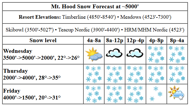
Today, Wednesday, starts high overcast. Snow returns tonight. The snow level will be 3500′ early, 5000′ this afternoon, and will quickly fall back to 1500-2000′ overnight. Temps at 5000′ start in the mid to upper 20s, rise to the low-mid 30s, and drop back to the low-mid 20s tonight. During the day, all we’ll have is clouds. Snow starts up around 5pm, and gives us 0.4” to 0.5” water equivalent (WE) tonight. Call it 5-6” dry, fluffy powder. Wind: SSW 10-20 this morning, S 15-25 this afternoon, and W 40 overnight. The wind will be light enough during the day to give the resorts a shot at the more exposed lifts, should they be able to dig them out!
Thursday looks snowy all day and snowier overnight. Storm skiing, for sure, with enough wind for continuous refills! The snow level will be 1500-2000′ in the morning, 2500′ in the afternoon, and 4000′ after midnight. About 0.5” WE is forecast during the day along with strong west wind. Call that 5-8” fluffy new snow. Overnight, about 0.7” WE is forecast. With a little more S to the wind, there will be a little less orographic support. Call it 7-8” new snow. Wind: W 40-45 in the morning, WSW 30-35 in the afternoon, and WSW 40-45 after midnight.
Heavy snow continues on Friday, but this snow will be a bit warmer and a bit less fluffy. The snow level will be around 4000′ in the morning, 3500′ in the afternoon, and 1500′ under clear sky overnight. About 0.6” WE is forecast during the day along with strong wind. Call that 6-8” new. Overnight, just an inch. Wind: WSW 40-45 in the morning, W 40 in the afternoon, and W 30 overnight.
extended mt hood weather forecast
A break in the snowfall is forecast Saturday morning followed by warming temps and light to moderate wet snow in the afternoon. Models are all over the place for Sunday. It will be above freezing, but it’s unclear if it’ll be misty, drizzly, or wet. Moving on to the first three days of next week, we have anomalously warm weather with sunshine. After Wednesday, we fall right back in to winter with lots of snow in the forecast. Have a great time in the powder this week!
Was that helpful? I knew it was! Guess what? All of this crucial work – from your personal wind and snow reports to the invaluable TATAS updates – is made possible by my relentless efforts. Maintaining this labor of love isn’t easy. Each daily forecast takes hours. Website hosting, weather model access, and back-end admin work takes time and money. That’s where you come in.
YOUR CONTRIBUTION MAKES A DIFFERENCE
- SUPPORT ACCURATE, HYPER-LOCAL WEATHER FORECASTING
- ENABLE ACCESS FOR ALL, EVEN THOSE WITH LESS MEANS
- SUPPORT A COOL HUMAN WHO WORKS HARD SO YOU CAN PLAY
Take a moment to click one of the buttons below. Donate $19.99 or more (how much does this forecast enhance your life?) and get the email in your inbox. Whether it’s a renewing subscription (auto-renew) or a one-time donation, every contribution makes a real difference. Help me keep this labor of love alive, so we can all continue playing, commuting, and living in the Gorge with peace of mind and the best weather forecasts possible. Thank you!


Hood River, Oregon 97031


GORGE WIND FORECAST

Hi friends! Active and unstable weather continues through the weekend with chances for wind today, Thursday, and Friday. None of these possibilities looks great; the overall setup has offshore low pressure systems, atmospheric instability, and lots of rain. But it’s not impossible!
Wednesday starts with east wind. Peak speed will be 25mph at Iwash (Rooster) Rock and Stevenson early afternoon, and then it’ll drop to 15-20mph. As the first in a series of systems brings in rain around 5pm, the wind turns westerly. It’s possible we’ll see a short period of very gusty westerlies at 20mph or so between Stevenson and Viento, with even gustier 15-20 at Swell for the Executive Session (after 5pm). No promises on this one. Out east: as a low pressure system moves inland, there will be some wind on the west side of it, but again… very gusty, short-lived, and not worth chasing unless you’re pretending to chase wind so you can have dinner at Amayah’s. River flow over the last 24 hours was 92-168kcfs, river temp is 43.90F, and high temp forecast is 50F with clouds in the morning and rain in the evening.
Thursday sees frontal wind combine with support from moderately strong wind aloft. Areas west of The Dalles see 13-16ish mph into the afternoon with intermittent rain. Between Avery and Boardman, westerlies rise to gusty 21-25 on the sensors, which might be just barely enough for some winging out at Rufus. It’s going to be very marginal. After 2pm, the wind drops to 7-10mph west of The Dalles and 17-20 east of The Dalles. High temp: 50F and cloudy with rain.
Friday looks somewhat like Thursday. Ensembles give a slightly better chance of slightly-less-marginal wind, but there’s a lot of range in those ensembles. For now, let’s say similar speed to Friday with a lot more atmospheric instability. That’s not going to help the wind. Both weekend days look light/variable. Next week’s warmer weather will likely be accompanied by east wind. That’s all for now. Have a great day out there!
BARE BONES HOOD RIVER WEATHER FORECAST
Clouds this morning. Rain after 5pm. Temps start in the upper 30s and rise to 50 or so. Light easterlies until 5pm, then moderate westerlies. 35% chance of rainbows. Thursday will be cloudy with intermittent rain all day and night. Temps star in the upper 30s and rise to 50. Moderate westerlies. 99.9% chance of rainbows. Friday will be showery. Temps start in the low 40s and rise to the low 50s. Moderate westerlies. 99% chance of rainbows.
TEMIRA’S AWESOME TRAVEL ADVISORY SERVICE
HYPERLOCAL WEATHER FORECAST FOR THE COLUMBIA GORGE
THE DALLES, HOOD RIVER, WHITE SALMON, TROUT LAKE, STEVENSON, CASCADE LOCKS, PARKDALE, ODELL, HUSUM, BZ, MILL A, WILLARD, GOLDENDALE, RUFUS, ARLINGTON, boardman
Good morning, neighbors! I’m still considering refusing to discuss any weather other than next Monday, Tuesday, and Wednesday, when temps will make a push for 65-70 degrees. While I think about that and my willingness to discuss any other days and any other weather, let’s check in with Glenwood…
glenwood
The Little Hamlet That Could is 28 degrees and high overcast this morning. Let’s move on to next Monday, Tuesday, and Wednesday: did I mention the potential for 65-70 degree weather?
today (it’s wednesday)
That won’t happen today. In case you haven’t heard, It’s hump day. If you haven’t got your hump on, go ahead and do it. Unless you identify as Ace, in which case, you’re completely exempt from the humping requirement. I recommend you save today’s humping for after 5pm. Before that, we’ll have dry weather and high clouds, which will give you a chance to get outside shit done. Don’t waste that window humping, and don’t hump in front of a window. Rain arrives around 5pm, messes with the commute home from the city (it’ll be heavy near Cascade Locks), and extends all the way to Amayah’s Indian Curry and Kababs, the location formerly known as Biggs. Temps today max out near 50, making things feel decidedly middle-aged. Wind will be E 25mph at Stevenson and Iwash (dick) Rock most of the day before turning westerly this evening as rain arrives.
thursday
Rain sticks around west of Mosier all day Thursday. In the morning and in the afternoon, rain also extends farther east, maybe to the untrimmed Arlington Triangle and also in SW/Sherm areas. With temps aloft at -4C in the morning, morning snow is totally 100% possible near Parkdale, Mill A, Trout Lake, Snowden, and other elevated areas away from the warming influence of the river westerlies. Snow totals: 1-3” (higher totals to the north). Temps max out around 50, and westerlies stick around at 15mph west of The Dalles and 20-25 east of The Dalles. Wind plus rain equals rainbows. If you like rainbows, you’d better buck the fuck up and like queer people (like me) too, because we’re inseparable from your beloved rainbows. Oh, and we’re fun.
friday
On to Friday: showers and sprinkles hang out all day as far east as Hood River with periods of rain east of The Dalles in the afternoon. The whole damned region – all of you, including those of you denying the possibility – have a chance of thunder and small hail in the afternoon. Wind will be W 15-25 all day all through the Gorge. Rainbows: definitely. Queer folks: yes, us too, and we’ve been here forever and ever and ever back into the time before record keeping – we just have more visibility these days.
extended gorge weather forecast
Saturday: cloudy and dry until early afternoon when rain arrives. Sunday: not quite sure. Models are trending down on precip amounts for Sunday, but they’re taking the dewpoint and available moisture up. It’ll be muggy and cloudy, at the very least. Now, back to the only weather I care about right now: next Monday, Tuesday, and Wednesday. Did I mention it’s going to be 65-70 degrees? Better make the most of it – after that fabulous stretch of fabulousness, we’ll be right back into cool, wet weather. And then I’m hopping on a plane and heading off to a month-long silent retreat for the whole month of April. Let me give you a forecast for April now: April showers bring May flowers. Safe travels. -TATAS
HEY! DON’T STOP READING! Is this community-focused forecast helpful to you? It sure is! It takes me a couple hours a day to write. Please join your friends and neighbors in contributing to keep it going. Venmo: @thegorgeismygym PayPal: twomirrors@gmail.com USPS: Temira / PO Box 841 / Hood River, Oregon 97031 You can test out the forecast subscription for a few days for free by signing up below. Easy! Do it!
