

MT HOOD SNOW FORECAST

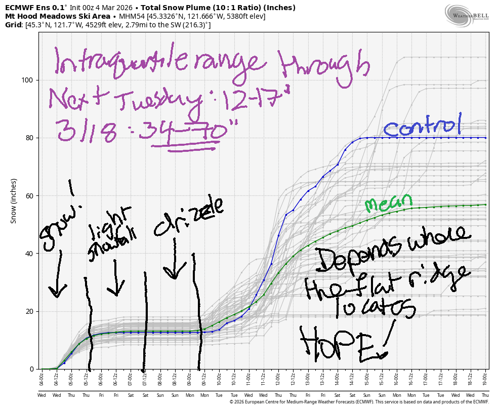
Hey skiers and snowboarders! Once again, “hope is in the forecast”. I put that in quotes, because the hope has repeatedly fizzled this year with the passage of time. If nothing else, we should get decent snowfall today (Wednesday) into Thursday before the weather warms into the weekend. Starting sometime in the first half of next week, colder air drops down from Canada and encounters progressive flow over the Pacific. Everything depends on how far south that cooler air progresses. If it drops far enough south to cool off Mt Hood, we get tons of snow. Fingers crossed for that. The intraquartile range through march 18th currently stands at 34-70”.
Short term Mt Hood snow forecast
Wednesday brings decent snowfall as a cold front arrives with northwest wind. That’s the right direction for Mt Hood orographics (terrain enhancement of snowfall). While forecasts are all over the place, we could get lucky… The snow level starts around 5000′ and quickly drops to 4000′. With the passage of the cold front tonight, the snow level drops to 1500′. During the day, we’ll see around 0.8” water equivalent (WE) for 6-8” dense snow. Overnight, another 0.4” to 0.5” WE is expected for 5-6” increasingly fluffy power. Wind will be W 30 early, WNW 35 in the afternoon, and NW 30 overnight; that speed and direction could increase snowfall by 20-30%. Vote for that, please!
Thursday brings storm skiing. The snow level will be 1500′ in the morning and will rise to 2500′ in the afternoon. It holds overnight. During the day, models give us 0.2” to 0.3” WE for 3-4” powder. Overnight, another 0.2” WE is forecast for a couple more increasing of snow. Wind will be NW 25-30 all day and will fade to W 15-20 overnight. NW wind at 30mph is right on the edge to impact lift ops. Do check the websites before heading up. Also, the NW wind during the day could enhance snowfall by 20-30%. Again, we request you vote for orographic enhancement!
Extended Mt Hood Snow Forecast
Friday brings light snow to start along with warming temps. We may see a switch to mixed precip overnight, and the snowfall may also hold until Saturday morning. Either way, not much precip is anticipated: just 0.1” WE during the day for an inch or so of snow and a trace overnight. Wind will be W 15-20 pretty much all day and all night.
As of right now, Saturday looks cloudy, warmer (mid 30s) with intermittent light orographic drizzle possible thanks to W or NW wind. Temps drop sometime Sunday and leave us with light snowfall, yet again. By Tuesday, models agreement falls apart. As I said at the start of this forecast, we’re waiting to see how far south this trough progresses. Farther south: lots of snow. In the meantime… enjoy the fresh snow that’s arriving today! I’ll see you on the slopes!
Was that helpful? I knew it was! Guess what? All of this crucial work – from your personal wind and snow reports to the invaluable TATAS updates – is made possible by my relentless efforts. Maintaining this labor of love isn’t easy. Each daily forecast takes hours. Website hosting, weather model access, and back-end admin work takes time and money. That’s where you come in.
YOUR CONTRIBUTION MAKES A DIFFERENCE
- SUPPORT ACCURATE, HYPER-LOCAL WEATHER FORECASTING
- ENABLE ACCESS FOR ALL, EVEN THOSE WITH LESS MEANS
- SUPPORT A COOL HUMAN WHO WORKS HARD SO YOU CAN PLAY
Take a moment to click one of the buttons below. Donate $19.99 or more (how much does this forecast enhance your life?) and get the email in your inbox. Whether it’s a renewing subscription (auto-renew) or a one-time donation, every contribution makes a real difference. Help me keep this labor of love alive, so we can all continue playing, commuting, and living in the Gorge with peace of mind and the best weather forecasts possible. Thank you!


Hood River, Oregon 97031


GORGE WIND FORECAST
If you’re still seeing yesterday’s and it’s after 9am, try opening this in an incognito window
SHORT-TERM gorge wind forecast
Hi friends! Thanks to offshore high pressure, we’ve got a streak of westerlies on the way.
Starting midday today or early afternoon, that high pressure (1032+ mb) sets up and starts the westerlies. This is the sort of setup where the wind can easily exceed the forecasts. It also tends to be a good setup for Rufus. Once this setup gets going, some sort of west wind should be here through the latter part of next week unless there’s a dramatic change in the forecast!
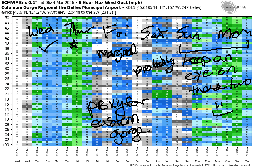
Looking at Wednesday morning, you wouldn’t expect this. Gradients were nearly flat to start the day. This system pushes through mid-afternoon (hopefully – it’d be a bummer if it waited until after dark). We’ll see areas west of The Dalles climb to 13-16mph with drizzle possible. Out east, we’ll have a slow build to 28-32mph between Avery and Threemile, strongest between 2pm and 5pm. It’s worth noting that areas west of The Dalles could climb to 20-23 late afternoon into the evening as the eastern Gorge drops off to 26-29. All that said, we could see all sites over-perform late afternoon into the evening as very strong offshore high pressure exerts its influence. River flow over the last 24 hours was 156-196kcfs (161-196kcfs at Rufus), river temp is 42.3F, and high temp forecast is 52F with drizzle to the west and partly cloudy sky east of The Dalles.
RIVER FLOW FOR SITES BETWEEN AVERY (EAST OF THE DALLES) AND RUFUS: CLICK HERE FOR JOHN DAY DAM FLOW.
RIVER FLOW FOR SITES BETWEEN STEVENSON AND DOUG’S BEACH (WEST OF THE DALLES): CLICK HERE FOR THE DALLES DAM FLOW

LONGER-TERM gorge wind forecast
Another weather system approaches on Thursday with another shot at decent wind out east. Early morning westerlies will be 13-16mph from Stevenson to The Dalles with 27-30mph from Avery to Rufus and 20-23mph to the east. We’ll see the wind drop a little midday before rebuilding to gusty 28-32mph from Avery to Arlington in the afternoon. West of The Dalles, the wind is likely to stay below the 17-20mph threshold all day. High temp: 49F with clouds to the west and decreasing clouds becoming mostly clear out east, where temps will climb to the mid 50s.
Somewhat lesser wind is forecast on Friday. Models call for anything from less than 10mph to upper teens. There’s too much uncertainty to really call it go or no-go. High temp: 52F for Hood River and 57F out in the desert with drizzle as far east as Avery until late morning or early afternoon.
Saturday looks like 20-23mph probably near both the Hatch and Rufus. Models are all over the place on Sunday, but the ensembles are hinting at the possibility of another big day. Progressive weather sets up for next week with straight westerly flow or perhaps northwesterly flow aloft. This is a decent setup for westerlies. The Euro ensemble is very excited about a possible cold front and associated strong westerlies in the Sunday-Monday time frame, and the ensembles hold on to some sort of west flow through next Thursday, although certainty is much lower. You can tell I’m excited by how many words I just typed. Hope to see some of you on the river!
BARE BONES HOOD RIVER WEATHER FORECAST
Rain today decreasing after 4pm but still intermittently drizzly. Temps start in the mid 40s and rise to the low 50s. Light westerlies early. Moderate later. 99% chance of rainbows. Thursday will be cloudy with drizzle early and dry weather after sunrise. Temps start near 40 and rise to the upper 40s. Moderate westerlies. 79% chance of rainbows. Friday will be drizzly. Temps start near 40 and rise to the low 50s. Light westerlies. 98% chance of rainbows.
TEMIRA’S AWESOME TRAVEL ADVISORY SERVICE
HYPERLOCAL WEATHER FORECAST FOR THE COLUMBIA GORGE
THE DALLES, HOOD RIVER, WHITE SALMON, TROUT LAKE, STEVENSON, CASCADE LOCKS, PARKDALE, ODELL, HUSUM, BZ, MILL A, WILLARD, GOLDENDALE, RUFUS, ARLINGTON, boardman
Good morning, neighbors! Thanks for giving me two days off so I could go to Seattle and hang out with my meditation community. I had a super-fun time connecting with friends and teaching. I hope you enjoyed the beautiful, sunny, warm weather on Monday! It won’t be warm and sunny the next few days, but we will pick up some much-needed rain, Wind Johnnies will get their beloved westerlies, and all of us will be treated to rainbows!
Glenwood this morning
Looking at Wednesday morning, Glenwood started out at 42 degrees, the answer to life, the universe, and everything. Note, the question to this answer could be… “What’s SIX times SEVEN?” SIX-SEVEN!!!! Other local news… roads appear clear of both ice and !CE this morning. Stay safe, everyone!
Today’s Gorge weather forecast
For the rest of us today… drizzle on and off to The Dalles (and south Wasco) until late afternoon with drizzle to Hood River overnight. West wind picks up after 10am and eventually builds to 20mph west of The Dalles and 30mph east of The Dalles all the way to Hermiston. Combine west wind and rain and you get… RAINBOWS! FUCK YEAH! Temps max out in the low 50s in Hood River, near 55F in The Dalles, and in the upper 50s out in the desert.
Thursday’s Gorge weather forecast
Overnight into Thursday, a cold front swings through and drives the snow level down to 1500-2000′. Most of the moisture will be done by daybreak, so little to no accumulation is expected. Another, weaker system during the day could cause a few flurries in Willard, Mill A, Underwood, Trout Lake, and Snowden, but warming temps in the afternoon turn the snow to rain. Drizzle (mostly) stays west of Hood River. Temps on Thursday rise to the upper 40s (west), low 50s (The Dalles), and upper 50s (The Desert). West wind will be 15mph west of The Dalles early with 25-30mph form Avery to Rufus and 20mph to the east. Afternoon wind holds at 15-20mph west of The Dalles and bounces around +/- 5mph of 30mph east of The Dalles to the Arlington Triangle. Expect sunshine out east and clouds to the west.
Extended Gorge weather forecast
Friday will be a cloudy. Drizzle extends east to Celilo Village through noon and tapers off after that. For areas west of Wyeth, drizzle continues. Highs will be in the low 50s (west) with temps steadily increasing towards Pasco, where the forecast high is 58F. Wind will be west 15mph or so, but there’s lot of uncertainty about the details of the pesky westerlies.
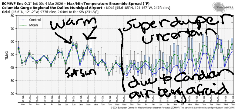
Our weekend forecast looks relatively warm – 55+ degrees – with widespread drizzle Saturday morning and dry weather east of Cascade Locks Saturday afternoon. Sunday brings another round of warm drizzle – temps in Pasco will rise to the mid 60’s!!! Gorge: upper 50s. West wind of some sort is on the schedule both days.
Uncertainty rises late Sunday into early next week as a trough of Canadian air contemplates how far south it will travel. Canadians are a bit tentative about traveling deep into the United States right now due to the possibility of being detained by !CE, and this cold air is also afraid. If it chooses to risk a southerly excursion, we’ll end up cold and damp with snow in the mountains. Let’s just vote for that as we desperately need snow in the mountains.
You can support the cold air’s sense of safety by undermining the pillars of authoritarianism. Start by marking your calendar for the next Big Protest on March 28th, and continue with your economic boycotts of companies that support the deployment of military and/or quasi-military troops against us. Also, DON’T COMPLY IN ADVANCE – DON’T LET FEAR SILENCE YOU! Your voice is your power. Together we shall undermine this tsunami of hatred and violence and replace it with care for each other and a deep understanding of each person’s humanity. Safe travels. -TATAS
HEY! DON’T STOP READING! Is this community-focused forecast helpful to you? It sure is! It takes me a couple hours a day to write. Please join your friends and neighbors in contributing to keep it going. Venmo: @thegorgeismygym PayPal: twomirrors@gmail.com USPS: Temira / PO Box 841 / Hood River, Oregon 97031 You can test out the forecast subscription for a few days for free by signing up below. Easy! Do it!
JONES BEACH, SAUVIE ISLAND, & COAST FORECAST
ON WINTER VACATION UNLESS DESPERATELY NEEDED.

Leave a Reply