

MT HOOD SNOW FORECAST

Hey skiers and snowboarders! We’re finally getting some snow today! While it’s not quite stormy enough to really call it storm skiing, it’ll at least be snowing on you if you head to the mountain today! Flurries linger into Thursday morning, and then we’re set for another round of intense warming for the weekend, when temps on the slopes will far exceed 50 degrees!
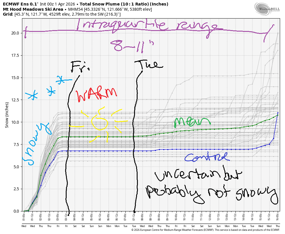
Short term Mt Hood snow forecast
Wednesday starts snowy with the snow level around 3500′. A warm front takes the snow level to 4500′ this afternoon, but a cold front quickly follows. In the evening, the snow level starts dropping. It bottoms out around 2000′ after midnight. We’re expecting 7-11” of new snow by tomorrow morning according to the ECMWF. The GFS is a bit more optimistic with 11-13”. Given the wind direction, I’m leaning towards the lower end of the range. Wind will be SW 20-25 this morning, SW 20-30 this afternoon, and NW 30 after midnight. High temp at 5000′ will be 30F or so.
Thursday starts off breezy with lingering orographic (terrain-enhanced) clouds and flurries. Clouds linger below 5000′ into the afternoon before the sky clears overnight. The snow level will be 2000′-2500′ all day, and the free air freezing level will be around 4000′ overnight. We’re expecting just an inch or so of additional snow before the sky clears. Wind will be NW 30 all day. This will take the highest lifts out of commission and could affect some other lifts. NW 30 is right on the edge for lift impacts. Temps max out around 31F.
Extended Mt Hood Snow Forecast
Friday will be sunny all day. The free air freezing level rises from somewhere in the 0-4000′ range (isothermal situation) in the morning to 7000′ in the afternoon and 8000′ overnight. Wind will be W 10 in the morning, SW 5-10 in the afternoon, and light/variable overnight. Temps at 5000′ max out around 40F.
Saturday and Sunday both look warm and sunny with light wind. High temps climb to the low 50s on Saturday and into the upper 50s on Sunday. Given the high sun angle, the snow will turn sticky quickly. Wax with yellow for the best results. Beyond this weekend, models aren’t clear on the details, but they’re clear on the general picture: too warm for snow, and not much moisture around anyway. Get out there and get some turns before it’s gone!
Was that helpful? I knew it was! Guess what? All of this crucial work – from your personal wind and snow reports to the invaluable TATAS updates – is made possible by my relentless efforts. Maintaining this labor of love isn’t easy. Each daily forecast takes hours. Website hosting, weather model access, and back-end admin work takes time and money. That’s where you come in.
YOUR CONTRIBUTION MAKES A DIFFERENCE
- SUPPORT ACCURATE, HYPER-LOCAL WEATHER FORECASTING
- ENABLE ACCESS FOR ALL, EVEN THOSE WITH LESS MEANS
- SUPPORT A COOL HUMAN WHO WORKS HARD SO YOU CAN PLAY
Take a moment to click one of the buttons below. Donate $19.99 or more (how much does this forecast enhance your life?) and get the email in your inbox. Whether it’s a renewing subscription (auto-renew) or a one-time donation, every contribution makes a real difference. Help me keep this labor of love alive, so we can all continue playing, commuting, and living in the Gorge with peace of mind and the best weather forecasts possible. Thank you!


Hood River, Oregon 97031


GORGE WIND FORECAST
If you’re still seeing yesterday’s and it’s after 9am, try opening this in an incognito window
SHORT-TERM gorge wind forecast
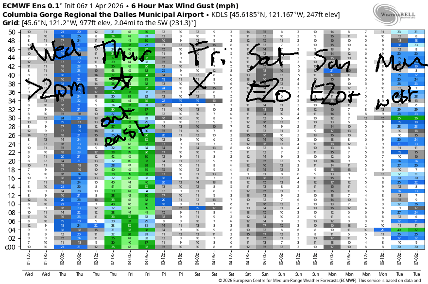
Hi friends! I’m doing an online retreat this week, but I still got your back with the forecast! Best chances for wind in the next five days are late today (marginal and gusty), Thursday (very good), and Sunday (maybe strong enough easterly). There’s some hint of westerlies next Monday or Tuesday, but model agreement is poor for now.
Looking at Wednesday, we started with basically flat gradients (29.68-29.69) and light/variable wind. Easterlies rise to 15mph at the usual spots (Iwash, Stevenson, Viento, Home Valley) midday. As a cold front swings through mid to late afternoon, westerlies return. We’ll have gusty 14-17mph from Stevenson to Doug’s (perhaps more, briefly, at the Hatch and Viento) with gusty 18-22mph from Avery to Arlington. After 5pm, the wind picks up more east of The Dalles, with gusty 20-25mph likely. River flow over the last 24 hours was 209-242kcfs, river temp is 47.1F, and high temp forecast is 52F and rainy in Hood River.
RIVER FLOW FOR SITES BETWEEN AVERY (EAST OF THE DALLES) AND RUFUS: CLICK HERE FOR JOHN DAY DAM FLOW.
RIVER FLOW FOR SITES BETWEEN STEVENSON AND DOUG’S BEACH (WEST OF THE DALLES): CLICK HERE FOR THE DALLES DAM FLOW

LONGER-TERM gorge wind forecast
Thursday’s your day if you’re seeking strong wind. A weak low moves inland, high pressure builds offshore, upper-level air turns northwesterly, and a cross-Cascade temp gradient develops. The day starts with 15-18mph from Viento to Hood River with 23-26mph from Mosier to Boardman. By mid-morning, westerlies rise to 28-32mph from Lyle to Arlington and 20-23mph east of Arlington to Hermiston. Models keep the western Gorge cloudy all day and drive the wind down to 10-15mph or less. After 5pm, the eastern Gorge drops to 22-25mph. High temp: 52F in Hood River, 58F way out in the desert with mid-level clouds persisting for much of the day and contributing to gusty conditions.
Friday sees high pressure build inland. This pretty much shuts the wind down – we’ll see westerlies under 10mph all day. High temp: 62F and sunny. Easterlies return on Saturday thanks to a heat low in SW Oregon. You’ll find E 20mph or so at the usual spots. Sunday brings stronger easterlies, perhaps 30-35mph at Iwash (Rooster) Rock. The high pressure (maybe) breaks down early next week. If you believe the GFS deterministic, we’ll have a couple solid westerly days to start next week. ECMWF: not as optimistic, but still westerly. Enjoy Thursday’s wind – I’ll be rooting for all of you as I’m sitting/walking/sitting/listening to dharma talks!

BARE BONES HOOD RIVER WEATHER FORECAST
Rainy today. Temps start in the low 40s and rise to the low 50s. Calm wind this morning. Moderate westerlies later. 99% chance of rainbows. Thursday will be showery early then partly cloudy. Temps start in the upper 30s and rise to the low 50s. Moderate westerlies. 99% chance of rainbows. Friday will be mostly clear. Temps start in the mid 30s and rise to the low 60s. Light westerlies. No rainbows.
TEMIRA’S AWESOME TRAVEL ADVISORY SERVICE
HYPERLOCAL WEATHER FORECAST FOR THE COLUMBIA GORGE
THE DALLES, HOOD RIVER, WHITE SALMON, TROUT LAKE, STEVENSON, CASCADE LOCKS, PARKDALE, ODELL, HUSUM, BZ, MILL A, WILLARD, GOLDENDALE, RUFUS, ARLINGTON, boardman
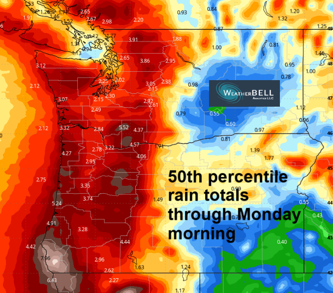
Good morning, neighbors! Finally – a rainy day! Perfect for me to be doing an online meditation retreat…I plan to sit in my pumpkin greenhouse and do weeding/walking meditation in the rain! After today, it’ll be a while before we see more rain, so you better get your ass (BUTTOCKS) out there and enjoy it! Weather highlights for this week: today’s rain, wind on Thursday, a chance of frost Friday, and 70+ degrees (!!!) on Sunday. The record high for that day is 78, so we won’t be setting that record, but we will be wearing short shorts!
Glenwood this morning
It’s not short-shorts weather today. Nope. It’s 37F in Glenwood this morning, where it never did get very cold this winter. Down lower in the low-elevation lowlands, we started at 42F, the answer to Life, The Universe, And Everything. I’m sure if that book were written today (RIP, Douglas Adams), the answer would be “six-seven”.
Today’s Gorge weather forecast
Today, Wednesday, started showery. Rain increases after 8am. Commuters: you’ll find heavy rain west of Viento from 8am to 2pm or so. The heavy rain moves east and extends to the Arlington Triangle (and even to parts of south Wasco, Sherman, and Gilliam Counties) between 2pm and 5pm. From early afternoon on, instability ups the shower intensity and could result in random bursts of hail, snain/wet snowflakes, and wind gusts. After 5pm, the desert dries out (and gets windy: gusty 20-30mph). Areas west of The Dalles see intermittent showers linger overnight. By Thursday morning, the snow level will be down around 2000′. Some of you (Underwood, Trout Lake, Willard, Snowden, maybe Parkdale) could pick up a trace.
Thursday’s Gorge weather forecast
Showers stick around, on and off, as far east as Hood River through 11am Thursday. This results in numerous rainbows, which angers people who don’t like or understand us LGBTQ+ folks. Ma Nature loves us queers. Model yourself after her and love us too! Morning temps on Thursday will be in the upper 30s. Given the presence of west wind down low and NW wind up high, frost is unlikely. Sub-freezing temps are possible in Glenwood and locations above 2000′. By afternoon, we’ll have partly cloudy sky and 52F (west), 54F (The Dalles) and 58F (The Desert). Early wind will be 15-20mph west of Mosier and 20-25mph to the east. Afternoon: 10-15mph west of Mosier and 25-35mph from Mosier to Arlington’s Triangle. East of the Triangle, you’ll find 25mph wind.
Friday’s Gorge weather forecast
On Friday morning, we’ll have mostly clear sky, light wind, and 850mb temps around 0C. Dewpoints will be 28-33F near the Nch’i Wana (Big River) and in the lower 20s away from it. This puts us at risk for frost. Glenwood: 22-26F. Parkdale, Mosier, The Dalles, and Odell: 29-33F.
NOTE: snow is accumulating on Mt. Defiance RIGHT FUCKING NOW. Do not plant your tomatoes.
Rest of Friday: sunny, 62-63F, and light wind. PERFECT!
Extended Gorge weather forecast
We’ll have another calm, clear morning on Saturday with similar dewpoints. The main difference is that temps will be warmer aloft. We’ll revisit the chance of frost as we get closer – Saturday is a long time from now, and at the rate the planet is warming, we could gain another degree Celsius by then and not have to worry about frost. Highs on Saturday will be in the upper 60s. Wind: light to moderate easterly. Sunday: EVEN WARMER!!! We’ll have sunshine, east wind, and temps in the low 70s.
Beyond Sunday, models are less certain, but they do indicate some degree of cooling and a likely return to west wind, higher dewpoints, and happier boardheads. Safe travels in the rain today. -TATAS
HEY! DON’T STOP READING! Is this community-focused forecast helpful to you? It sure is! It takes me a couple hours a day to write. Please join your friends and neighbors in contributing to keep it going. Venmo: @thegorgeismygym PayPal: twomirrors@gmail.com USPS: Temira / PO Box 841 / Hood River, Oregon 97031 You can test out the forecast subscription for a few days for free by signing up below. Easy! Do it!
JONES BEACH, SAUVIE ISLAND, & COAST FORECAST
ON WINTER VACATION UNLESS DESPERATELY NEEDED.

Leave a Reply